
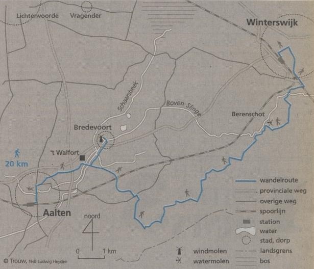
From Aalten to Winterswijk
The section of the Scholtenpad from Aalten to Winterswijk is about 20 kilometres long and follows mainly sandy tracks. Aalten and Winterswijk can both be reached by train, and at both stations the Scholtenpad is signposted immediately with red-and-white waymarks. The complete Scholtenpad is a long-distance footpath; a guide with good maps is available from bookshops specialising in walking routes.
At the Berenschot watermill, just south of Winterswijk, the ‘open-air museum’ picture is complete. The wheel turns in the churning water, the miller carries sacks, and upstairs, in a room open to the public, heavy millstones grind animal feed. Time seems to have stood still — perhaps a cliché, but at Berenschot the phrase immediately springs to mind.
In fact, the whole Scholtenpad is a journey through a world that has passed. Just beyond Aalten’s built-up area, the route to Winterswijk passes the fortified house Walfort. A few children race through the garden on mountain bikes; that is the only touch of the twentieth century here. Along the Keizersbeek we make a brief there-and-back detour to Bredevoort for a cup of coffee, in the little town that grew around a twelfth-century castle. Maarten van Rossum later turned the settlement into a fortress, complete with moats and real bastions. But in 1646 lightning struck the powder tower and the entire castle blew up, along with the drost.
Little of the actual fortifications can still be seen, yet Bredevoort remains picturesque. The town is a jumble of half-timbered houses set at all angles. According to the tourist office, this is the medieval street pattern. We walk past the statue of Rembrandt’s companion Hendrickje Stoffels to the windmill, which rises proudly above Bredevoort’s rooftops from an old section of the town rampart.
We return towards the main route, and in the woods we hear the midwinter-horn players giving an open-air concert today. Every kilometre or so there is another small group, sending notes from their traditional wooden horns out on the wind. The forest is weeping.
The Scholtenpad takes its name from the so-called scholte estates that developed around Winterswijk in the Middle Ages. At that time the nobility and monasteries were extremely powerful and owned large amounts of land. Farmers sought the protection of these powerful landowners and in return became serfs. By the end of the Middle Ages, the manorial estates in this region had grown so large that their management had to be entrusted to ‘branch managers’: leading farmers known as scholten, who acted as stewards.
After the Middle Ages, the power of the nobility declined while the scholten gained greater influence. They became owners themselves and developed into substantial farmers. Being a scholteboer became a mark of status. During the seventeenth and eighteenth centuries the scholten became increasingly powerful, particularly through lucrative trade with the west. Profits were used to buy further property, creating large, continuous areas of scholte estates.
Walkers regularly encounter these farmsteads on the route around Winterswijk. One of the attractions of the area is that small-scale farming still exists and there has been very little land consolidation. Farms and fields alternate with woods and streams. Together they form a single, coherent landscape.
The old sandy tracks were not straightened during later reorganisation. Instead they still wind awkwardly from farm to farm, bending around an old oak and crossing a small bridge that, for convenience, really ought to have been ten metres further to the left. The hedgerows and ash woods give the farming landscape an intimacy rarely found elsewhere in the Netherlands today.
We wind our way northwards. Some farms have been taken over by affluent newcomers; others are still occupied by working farmers. Beside the path stands an old henhouse, sheep graze nearby, and in the distance a young goat clambers over a wooden structure.
South of Winterswijk in particular, walkers practically stumble over lowland streams, many of which — unlike those elsewhere in the Netherlands — have been able to retain their natural course.
It is striking how deeply the streams have cut into the landscape. This is caused by the boulder-clay layer, which begins only a few metres beneath the sand and does not allow water to pass through. Excess water therefore cannot seep into the ground and instead enters the streams, gradually scouring them out. Coins lie in the water by the little bridges: throw one into the stream over your shoulder and, so the saying goes, you will have good luck. Unfortunately, we have only paper money and a few guilders with us.
HANS MARIJNISSEN