The Ringkampsbulten is a small nature reserve in the Aalten hamlet of Haart, situated between Kriegerdijk and Huiskermatedijk. The area consists of mixed woodland on partly hilly terrain. The cover-sand ridge within the forest sits at 41 metres above NAP (Normal Amsterdam Peil), making it the highest point in the municipality of Aalten.
In 1932 werd gedacht dat het een grafheuvel was, maar uit een kleine testopgraving bleek het om een natuurlijke heuvel te gaan. Buiten de heuvel werd echter wel een urn uit de IJzertijd (tot Vroeg-Romeins) gevonden, waardoor de naamgeving niet geheel onterecht is.
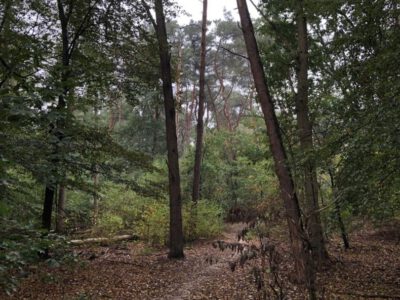
The cover-sand ridge consists of mixed forest with a high percentage of conifers. The lower, damper section to the south of the ridge primarily contains deciduous trees, including many alders. Along the walking path on the southern side, there is avenue planting in the form of pedunculate oaks.
The Ringkampsbulten is part of the Gelders Natuurnetwerk (Nature Network of Gelderland). The area is surrounded by agricultural land, making it a unique oasis for both flora and fauna. Measures have been taken to develop the woodland into a ‘natural stepping stone’, with the aim of promoting high biodiversity. This involves pursuing a varied forest structure with edges rich in texture and open clearings. Species that benefit from such a stepping stone include the White Admiral and the Purple Emperor butterflies.
The site has developed into a valuable piece of nature where rare plants and animals can flourish. For walkers and nature enthusiasts, De Ringkampsbulten offers a peaceful spot to enjoy the landscape, featuring beautiful views and varied vegetation. It is a lesser-known but cherished piece of nature among local residents, partly due to its tranquillity and small scale.