A 19-kilometre journey past eleven historical locations
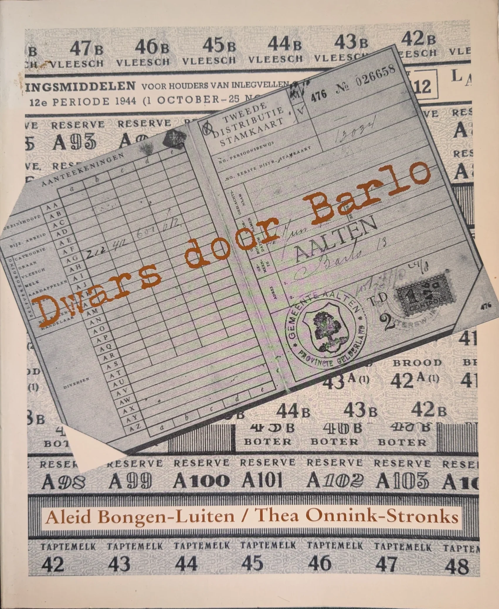
Book cover ‘Dwars door Barlo’, 1995
What was daily life like in Barlo during the war years? To keep the memories of this poignant time alive, the ‘Dwars door Barlo’ (National Museum of Hiding and Resistance) committee has launched a special interactive route. Using QR codes, walkers, cyclists, and motorists can listen to and watch stories from World War II at various locations via their smartphones.
The foundations of this project were laid back in 1994. To safeguard the memories of the war years in Barlo for the future, the former ‘Dwars Door Barlo’ (National Museum of Hiding and Resistance) foundation interviewed numerous local residents. These conversations, recorded on over seventy cassette tapes, provided the source material for the book ‘Dwars door Barlo’ (1995) at the time.
More than thirty years later, these stories have been brought to life once again. Not just on paper, but in the heart of the landscape where these events actually took place.
The route
The foundation has compiled a unique route that leads past the locations described so extensively in the book. The route is 19 kilometres long in total and passes eleven historical sites in Barlo. The journey can be completed on foot, by bicycle, or by car. The start and end points are located at pancake restaurant De Neeth (Neethweg 6).
How does it work?
Green posts with a number and a name are situated along the route. Each post features a QR code. By scanning this code with a smartphone, the story of that specific location appears instantly on the screen. There is also an audio button to have the story read aloud, allowing everyone to listen to the events of the past on-site.
Navigation is straightforward: a link to Google Maps is provided below each story to guide the visitor to the next point.
View from home
Those who prefer to view the route at home first or wish to listen to the stories beforehand can visit the website:
On July 19, 1963, the Tubantia newspaper reported:
Brown rat, photo for illustrative purposes
“Today, Mr. S. Douma officially retires from the public works department in Aalten. Thus far, Mr. Douma has been unwilling to be ‘persuaded’ to appear at the customary farewell gathering of the staff association. Out of modesty. With Mr. Douma, one of the most striking figures of the street scene is disappearing. He is particularly well-liked by the farming community. It was he, after all, who served the municipality of Aalten in the profession of rat-catcher.
However, this departure does not mean that the Aalten rats now have free rein. On the contrary, Mr. Douma is leaving everything behind except for the rats. For the time being, he will continue to handle this part of his duties at the request of the municipality. The hunt will likely become even more intensive, as the time is now available for it. The ‘rat-catcher’, who was in municipal service for over 30 years, has handled 1,172 pest control cases since the rat hunt began. How many rats he has killed is difficult to estimate, but it is certain that there are thousands. Mr. Douma hopes to add many more to that number.”
On Thursday, October 22, 1964, Douma, ‘the retired rat-catcher from Aalten’, was a guest on the NCRV radio program ‘Samen uit samen thuis’.
If you have more information or photos to supplement this article, please respond below or send us a message.
Legionnaire from Aalten in the French Foreign Legion
Aaltensche Courant, 5 August 1927
Willem Johan Marinus Anton Massen, known as Willem, was born on 2 March 1908 at Köstersbulte in Aalten, the son of Marinus Massen and Johanna Heinen. Before Willem’s first birthday, the family moved to Prinsenstraat 25.
He had a difficult childhood; his parents had been stripped of their parental rights. Willem’s father passed away on 4 March 1926. In August 1927, Willem was selected by ballot to carry out his military service in the Dutch army (the National Militia) in 1928.
Legionnaires of the French Foreign Legion in North Africa, 1930-1935 (Coll. NLL. Conv. HAASE, Willy), photo for illustrative purposes.
French Foreign Legion
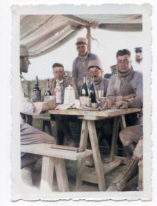
Willem Massen evidently had adventurous blood, and he allowed an acquaintance to persuade him to sign up for the French Foreign Legion—an elite branch of the French Army consisting of military mercenaries from all over the world. At that time, when a Dutchman enlisted in the Foreign Legion, he lost his Dutch nationality and became stateless.
Willem served in the Legion from 1930 to 1935, a period during which the unit was primarily deployed for ‘pacification’ and border patrols in the French colonies of North Africa, specifically Morocco and Algeria. The Legion was a melting pot of international volunteers, often seeking to escape their pasts, who led a harsh, disciplined existence under new identities in the rugged desert and mountain landscapes.
Return to the Netherlands
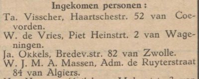
Aaltensche Courant, 10 January 1936
It is likely that Willem Massen completed his five-year contract, as he returned to the Netherlands in 1935. On 10 January 1936, the Aaltensche Courant reported in the ‘Arrivals’ column that Willem Massen had arrived from Algiers. He settled at Admiraal De Ruyterstraat 84, his mother’s address.
On 22 March 1943, the Twentsch Nieuwsblad reported that Willem had to appear in court for purchasing textiles without the legally required rationing coupons—a criminal offence under the rationing system controlled by the German occupier.
AALTEN
Without coupons. — On Friday, the Aalten tuckpointer W. J. M. A. Massen was summoned before the economic judge in Zutphen because he had purchased 1 tablecloth, 3 bedsheets, 3 pillowcases, and 47 towels without points. The Public Prosecutor demanded 4 months’ imprisonment, in addition to a fine of ƒ 200. The judge sentenced Massen in absentia to 1 month’s detention plus a ƒ 200 fine or 40 days’ detention, and forfeiture of the seized items, with acquittal of intent.
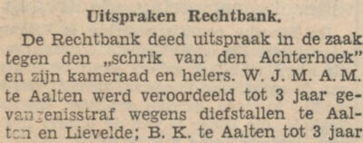
„The Terror of the Achterhoek”
Under this headline, the following report of a session at the Zutphen District Court appeared on 1 April 1947 in the Zutphensch dagblad voor Achterhoek en Veluwezoom:
In the summer of 1946, the Achterhoek was repeatedly unsettled by burglaries and thefts. This changed when a pair of Aalten residents, known as “heavy boys” (hardened criminals), were caught and, in October, remanded in custody at the Zutphen House of Detention. On Friday, this duo had to answer to the Zutphen District Court, presided over by Mr A. H. van der Giesen. The summons charged them with acting together and in concert to steal a quantity of fabric—totalling some 600 metres in length—approximately 700 rolls of peppermint, 20 packets of fat, a quantity of yarn, and two coupons of corduroy (manchester), respectively belonging to N.V. Bontweverij in Bredevoort, F. J. W, J. D. Meijnen, and N.V. Confectiefabriek v/h D. Kamphuis and J. H. Platter.
M. had confessed to the thefts immediately and continued to maintain before the court that he had acted alone. His comrade, B. K., likewise insisted that he had not taken part in these thefts. However, there were many indications that K. had also played a role.
Firstly, there was the statement from Sergeant Klein Geltink that one man could not possibly have transported 600 m of fabric alone. Furthermore, the buyer of this fabric, J. S. from Aalten, stated that M. had been accompanied by B. K. And the man who had concealed the goods, J. A. K. from Aalten, stood by the statement he gave to the police: that M. and K. had brought the 600 m of fabric to him together, and that one or the other would subsequently come to collect portions of the stock. He had received 50 guilders for his trouble. The Public Prosecutor, Baron Mr Van der Feltz, demanded a prison sentence of 3 years for M. and K.; 1/2 year (with credit for time served) for J. S.; and 1 year for J. A. K., taking into account as an aggravating circumstance that the goods were intended for the black market. Jhr. Mr W. H. de Jonge appeared as defence counsel in the first two cases.
In his [the counsel’s] view, legal proof of theft by K. had not been established. Undoubtedly the man had played a role in the matter, but in his view, he could be accused of nothing more than receiving stolen goods. For him, the defence requested an acquittal.
The defendant M., who made a frank confession (ruiterlijke bekentenis), does not, in his [the counsel’s] view, deserve the heavy sentence demanded by the Prosecutor. The advocate outlined the man’s life story. His youth had been very difficult; his parents had been stripped of their parental rights. He had attended a weaving school, but evidently possessed adventurous blood and had been persuaded by an acquaintance to sign up for the Foreign Legion. The man had served in Morocco for five years and consequently lost his Dutch citizenship. He had found it very difficult to secure work in this country. The counsel understood that the court would impose a heavy sentence, but he requested, firstly, that the time spent in pre-trial detention be deducted and, furthermore, that a milder sentence be imposed than the one demanded by the Prosecutor.
The Public Prosecutor felt that the defence should not present the case more favourably than it was. This man was known as “the terror of the Achterhoek”. He has 12 convictions on his criminal record. The Prosecutor was, however, willing to consider the request made by Mr De Jonge to allow the court-imposed sentence to be served in a State Labour Institution (rijkswerkinrichting). Verdict in 14 days.
Earlier, on 27 March 1947, the Algemeen Handelsblad had published a shorter report of this session under the headline “The Terror of the Achterhoek before the court”. It mentioned that M. was 39 years old and came from Aalten. Based on his traceable year of birth and place of origin, M. was therefore indeed Willem Massen.
This was confirmed by the court’s verdict published 14 days later, which this time included all the initials of Willem Massen’s forenames.
Zutphensch Dagblad, 14 April 1947
Naturalisation
In 1965, Willem Massen submitted a request for naturalisation. His explanatory memorandum stated:
17 Massen, Willem Johan Marinus Anton, born in Aalten (Gelderland) 2 March 1908, jointer, residing in Aalten, province of Gelderland:
Willem Johan Marinus Anton Massen, nominated under 17, was born a Dutch citizen in Aalten in 1908. He lost his nationality by enlisting in the French Foreign Legion in 1930 without Royal consent. He has lived in the Netherlands again since 1935. His wife and children hold Dutch citizenship. As a jointer, he provides for himself and his family.
In 1967, he lived at Haartsestraat 56 in Aalten. No further information is currently available regarding his family or the date of his death. If you have more information, please let us know!
Ale Douma
Willem Massen was not the only resident of Aalten to serve in the French Foreign Legion. In 1950, Ale Douma, then living in Aalten, submitted a request for naturalisation. Douma was born on 10 August 1908 in Dronrijp (Friesland), the son of Sjerp Douma and Elisabeth Schuurmans. He served in the Legion during the same period as Willem Massen (1930–1935).
During World War II, Douma stayed in Germany, where he was imprisoned in concentration camps twice due to his assistance to French prisoners of war. In 1967, he lived with his wife Else on the ground floor of a duplex house on Huygensstraat, at number 49.
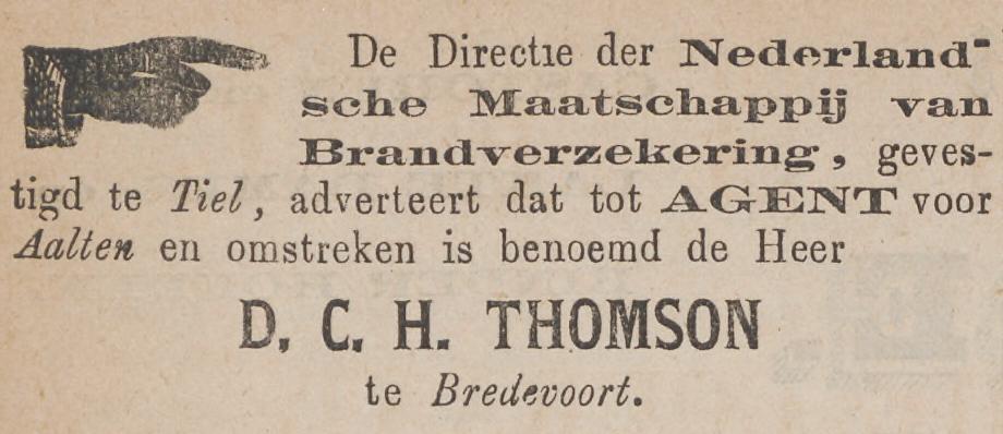
A military family with Scottish roots in Bredevoort
The family grave of the Thomson-van Hopbergen family is located at the General Cemetery on the Prins Mauritsstraat in Bredevoort. Although the tombstone has been marked by erosion, the monument is a reminder of a family that played a prominent role in Dutch military history, national politics and literature.
The legacy of the Scottish Brigade
The family’s roots lie in the Scottish Brigade, a unit of British soldiers hired by the United Provinces in the 17th and 18th centuries. After their military service, many of them settled permanently in the Netherlands, including James Thomson. He was married to Mary Rinck; their children were baptized in Tournai and Breda at the beginning of the 18th century. The military tradition in the family continued into the 20th century.
Location in Bredevoort
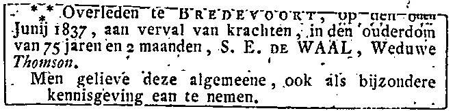
The bond with Bredevoort arose in the early nineteenth century through a grandson of the ancestor, also named James . This retired captain, born in 1759 in Nijmegen, lived there on the Prinsenstraat with his wife Susanna Elisabeth de Waal. James died in 1828 and Susanna in 1837. The house with its contents was valued at ƒ 3,805,-.
Their son, Jan Jacob Thomson (1784–1858), born in Maastricht and living with his family in Fort Crèvecoeur near ‘s-Hertogenbosch, was the sole heir. Jan Jacob was a lieutenant colonel and had made a career during the Napoleonic Wars. For his efforts during the Battle of Waterloo in 1815, in which he was wounded, he was made a knight in the Military Order of William.
In 1837 Jan Jacob entered into a second marriage with the 26 years younger Louiza Wilhelmina van Hopbergen (1810–1906) from Bredevoort. She was a daughter of the retired lieutenant Diederik Christoffel Hendricus van Hopbergen, also living on the Prinsenstraat. The family settled in Bredevoort.
Jan Jacob Thomson died on 11 October 1858 and was buried in the family grave in Bredevoort. Louise also found her final resting place there.
Several family members born in Bredevoort held social functions:
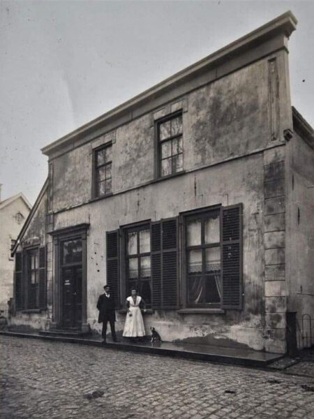
Diderik Christoffer Hendrikus Thomson (1840–1891) became a letter collector (holder of the local post office) in Bredevoort and will also have been buried in the family grave.
His son Jan Jacob Thomson (1882–1961) gained fame as a ‘poet-minister’. He was a pastor at the Dutch Protestant Union in Varsseveld and left behind an extensive oeuvre of poetry collections and literary-historical studies. After a turbulent and poetic life, he died in Baarn in 1961 and was buried there.
Jacque Willem Lodewijk Thomson (1846–1914) was mayor of the municipality of Appeltern from 1877 until his death.
Louis Thomson: Soldier and statesman
One of the most striking descendants of the family is Lodewijk Willem Johan Karel Thomson (1869–1914), a grandson of Lieutenant Colonel Jan Jacob. Lodewijk was a military cartographer, was sent to Batavia and Aceh, was a military attaché during the Boer War in South Africa and a member of the House of Representatives.
In 1914 he was sent to Albania, where he was killed in action in Durrës on 15 June 1914. Thomson was the first Dutch soldier to die during a peacekeeping mission. He was buried in Groningen.
Heritage in decline
Today, the funerary monument on the Prins Mauritsstraat is in a state of disrepair. Due to erosion and overdue maintenance, the inscriptions on the stone are becoming increasingly difficult to read. However, the grave is a monument to the connection of small Bredevoort with the great world history.
Family grave Thomson-van Hopbergen in Bredevoort (2020)Obituary Susanna Thomson-De Waal (1837)Jan Jacob Thomson (1784–1858)Zutphensche Courant, 10 October 1872Post office Bredevoort, 1918Louis William John Charles Thomson (1869–1914)
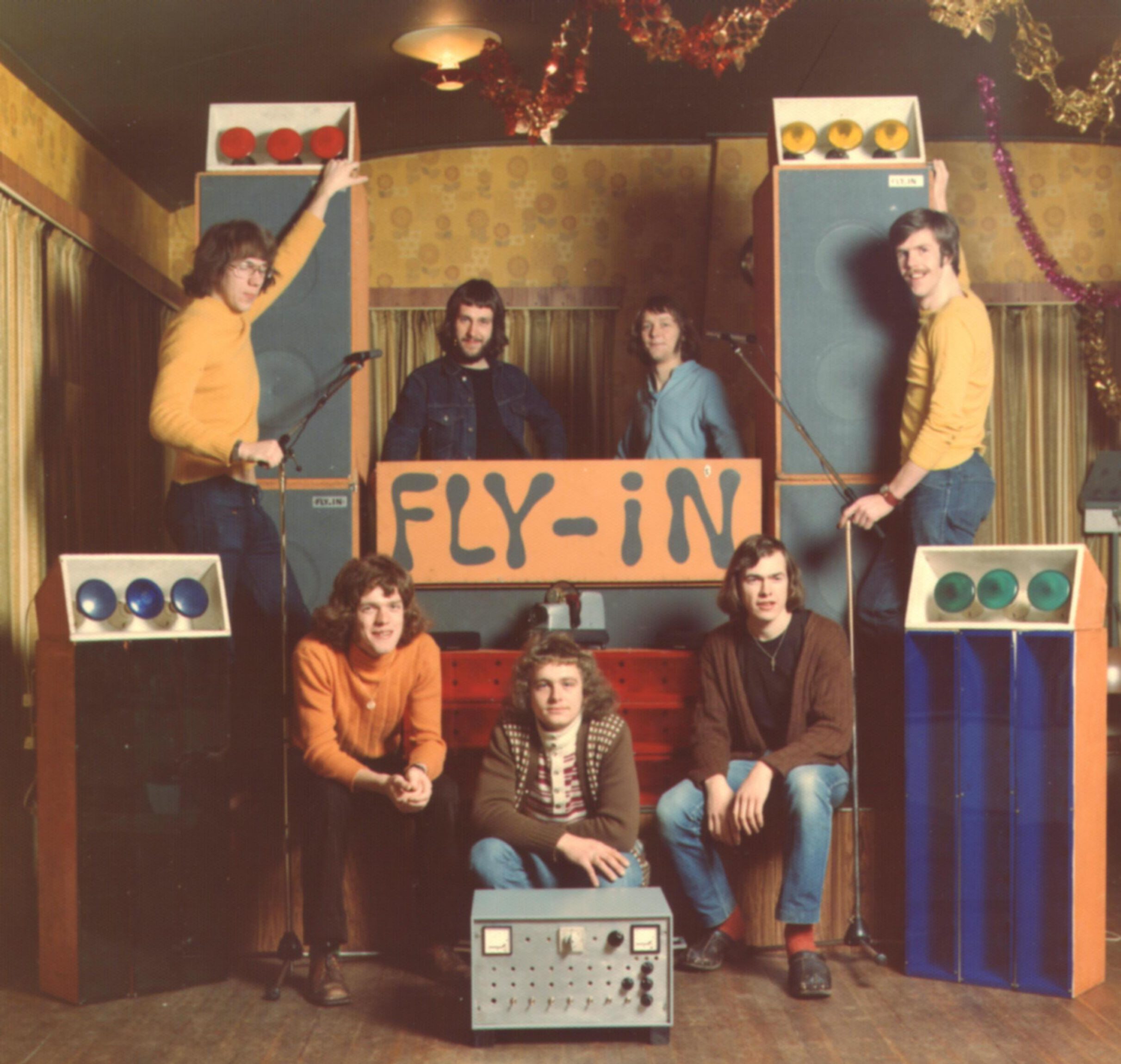
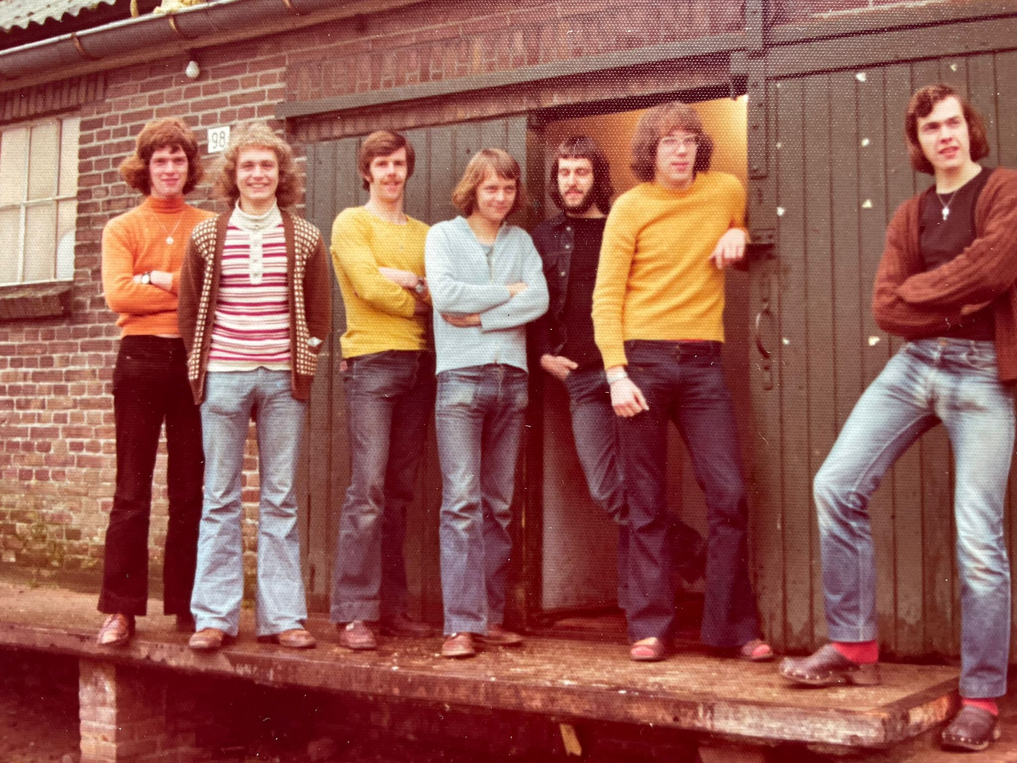
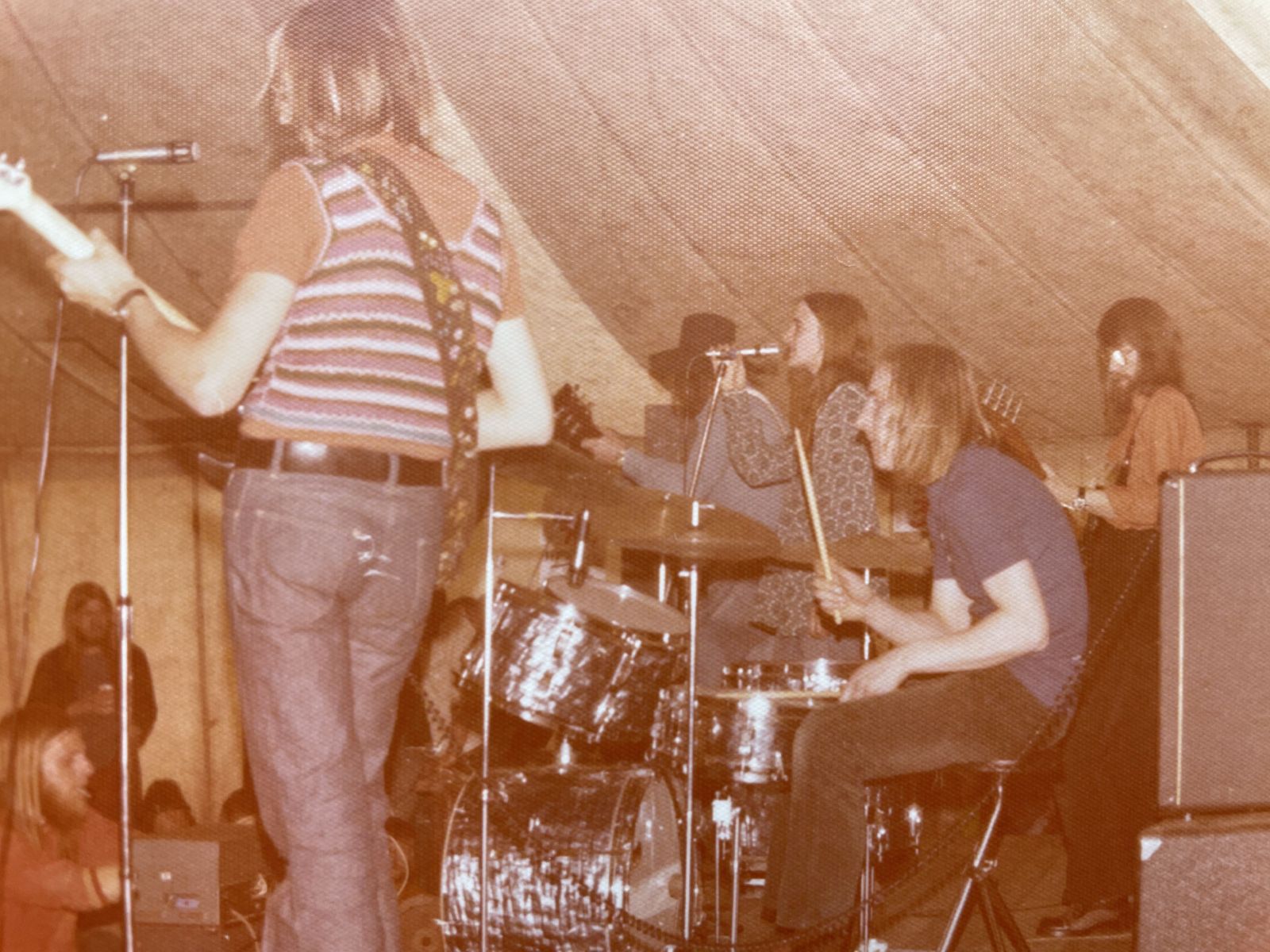
Discobar Fly-In in Barlo opened in 1969 in a vacant chicken coop on Barloseweg. The discobar was run by a group of young volunteers and quickly grew into a popular nightlife venue. In 1972, a new location was put into use. Many musicians and bands performed there, and music events were organized. At the end of 1974, Fly-In ceased to exist and continued as De Loods.
The origins of Fly-In lie in 1968, when various parties were held in Barlo. For these parties, part of a barn or farmhouse was partitioned off with black agricultural plastic and furnished with a record player, amplifier, and colored lights. Because this had to be reinstalled at a different location every time, a number of young people came up with the idea for a permanent venue.
Closing party, December 13, 1974
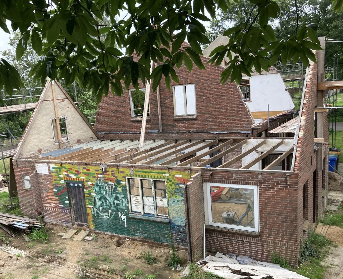
The former interior wall of Fly-In in 2024
First accommodation was a chicken coop
The first location of Fly-In was a vacant chicken coop behind Derk Ebbers’ grocery store on Barloseweg. After cleaning and pouring a concrete floor, discobar Fly-In opened on December 13, 1969. The words ‘Fly In’ were painted in large letters on an interior wall. During a renovation of the building in 2024, it turned out that these letters were still on the wall.
The original idea to use the space occasionally was quickly replaced by the plan to open every two weeks on Saturday. The evenings at Fly-In were concluded at 11:30 PM with a fixed closing tune — initially Comin’ Home Baby by Casey & the Pressure Group, later Time Is Tight by Booker T. & the MG’s.
Problems and drive-in shows
It soon became clear that the accommodation was not ideal: the space was too small (approximately 25 m²) and the furnishings were very simple; there was no cloakroom and no private toilet. Girls were allowed to use ‘Uncle Derk’s’ private toilet, while the boys could pick out a tree outside.
If a group of young people were still chatting on the road after the disco evening, Uncle Derk would come outside and shout: “staot neet op de weg te dralliën, maor gaot naor huus!” (don’t loiter on the road, go home!). After about a year, Fly-In stopped at this location and continued by providing drive-in shows in the wider area.
Fly-In with drive-in equipment
Fly-In board in front of the former warehouse
New location
After about a year, a new location was found in the vacant warehouse of the machinery association on Lichtenvoordsestraatweg in Barlo, directly opposite café Domme Aanleg. The former agricultural warehouse was renovated with a bar, a turntable, a cloakroom, and a toilet. Benches and tables were made from oak planks.
The official opening took place on Saturday, March 11, 1972. From that moment on, Fly-In was open on Wednesdays, Fridays, and Saturdays for members (membership card at ƒ 2.50).
Renovation and celebration
Due to the great interest, a renovation followed in the summer of 1972, during which the floor area was almost doubled. In 1974, the cloakroom was enlarged and extra toilets were installed.
On Saturday, December 15, 1972, the renovation was celebrated with over 800 guests in the Community Hall in Aalten with Earth & Fire, Mr. Albert Show, and Alquin. During the breaks, films were shown and records were played. The admission price was ƒ 6.50.
Jerney Kaagman (Earth & Fire) in the Community Hall in Aalten
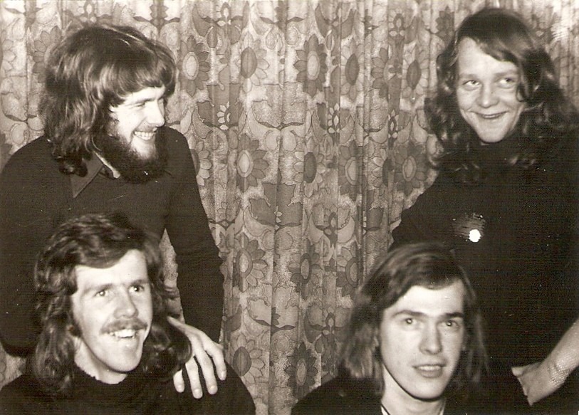
Board of the Fly-In Barlo Foundation, 1973
Fly-In Foundation
To prevent being held personally liable for any damages, the board decided in 1973 to establish a foundation.
After at least four board members had reached the age of majority (21 at the time), the ‘Fly-In Foundation’ was established at notary Obbink in Aalten. The foundation had a starting capital of one hundred guilders and aimed to organize and provide cultural and creative activities.
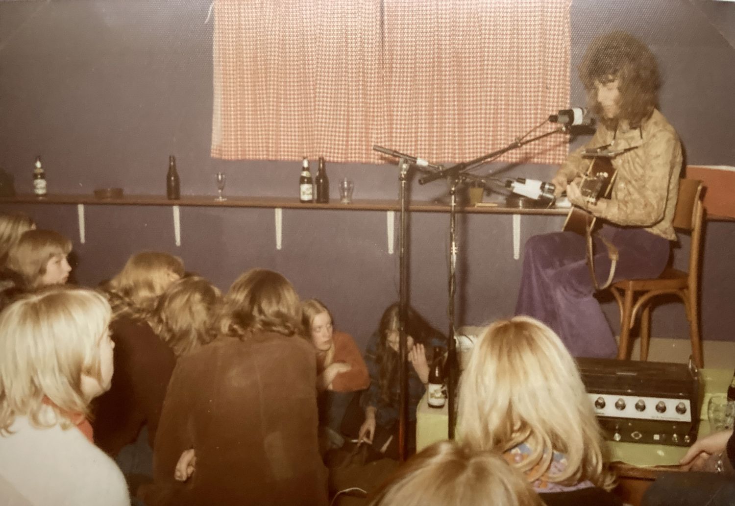
Performances and film screenings
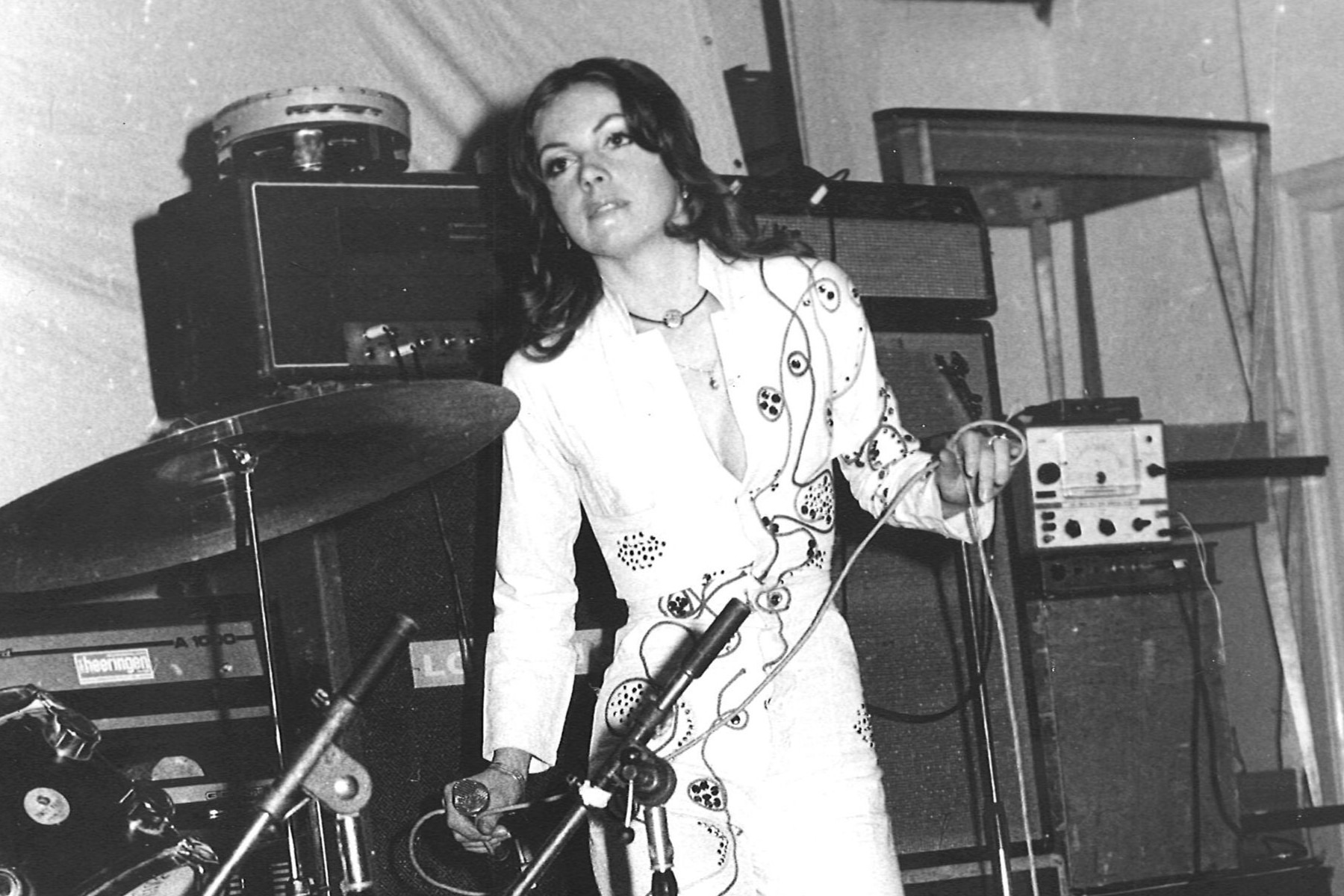
During Fly-In’s existence, many performances took place by bands and artists, including Kaz Lux, Kraayeveld, Tom Haket, Dimitri van Toren (Hé kom aan), Armand (Ben ik te min), and Shepstone & Dibbens.
Concerts were also regularly organized in the Community Hall, featuring performances by the Bintangs, Chicory Tip, Dizzy Man’s Band, Earth & Fire, Long Tall Ernie, Mayfly, Plastic Feet, Q65, and Solar Plexus, among others.
Armand at Fly-In, December 13, 1973
Puddingh at Paaspop in Aalten, 1974
Paaspop 1974
On April 15, 1974 (Easter Monday), Fly-In organized a festival under the name Paaspop. It took place in a festival tent on the grounds of AD’69 on Bocholtsestraatweg. The program included performances by Puddingh, Hobo String Band, Livin’ Blues, Kayak, Bronco, and Shakin’ Stevens & the Sunsets.
Two stages were built in the festival tent so that the bands could alternate, but due to trouble with Livin’ Blues’ van, this did not go entirely smoothly. Approximately 1,500 visitors attended the festival.
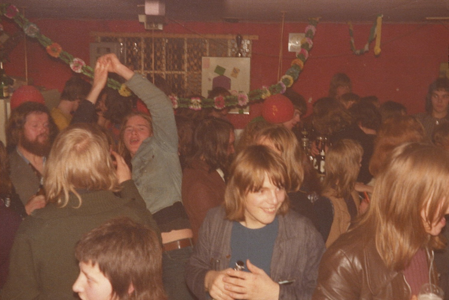
Closing party and poem
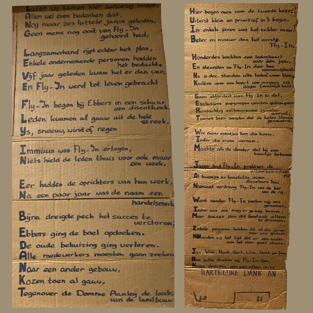
The closing party of Fly-In took place on December 13, 1974. The discobar would continue under the name De Loods.
At the closing party, the board was presented with a poem on a large piece of cardboard — an acrostic of 48 lines, of which the first letters together formed the following sentence:
“Long live Fly-In and thanks Huib, Henk, Gert, Wim, Jan, Wim and Jan.”
The poem is signed with the initials H.t.P. and B.H., but to date, it has not been possible to find out who these unknown poets were. If you happen to know, please respond at the bottom of this page!
Source
‘FLY-IN’ 1969-1974: The FLY-IN archive, Wim Simmelink
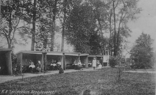
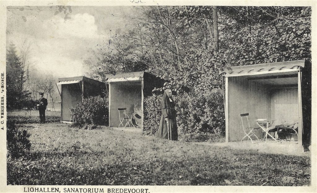
Located in the Vestingpark in Bredevoort are two so-called TB reclining pavilions (lighallen) dating from the early 20th century. They belonged to the former St Bernardus Roman Catholic Sanatorium, where tuberculosis patients were treated from 1907 to 1933.
Tuberculosis, commonly known at the time as “consumption”, was one of the leading causes of death in the Netherlands during the 19th and early 20th centuries. The disease was infectious, often fatal, and responsible for approximately a quarter of all deaths. Since no medication yet existed, treatment consisted primarily of rest, a healthy diet, fresh air, and sunlight.
Sanatoria—rest homes for long-term care—were established all over the Netherlands. A key component of the treatment was the use of reclining pavilions: wooden structures with one open side facing the sun, where patients spent hours or even the entire day in bed—often wrapped in blankets against the cold.
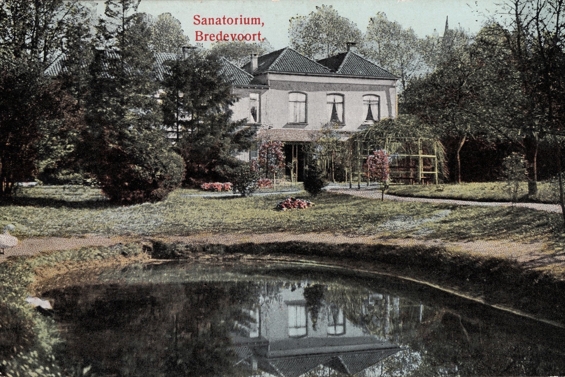
St Bernardus Sanatorium
the St Bernardus Roman Catholic Sanatorium was founded in 1897 on the initiative of Father Bernardus Mulders. Using his own capital, he purchased the former estate manager’s house of the Roelvink family and had it converted into a convent and care facility. The nursing care was entrusted to the Franciscan Sisters of Thuine.
From 1907 onwards, patients from across the country came to Bredevoort. In the large garden behind the building, now the Vestingpark, at least ten wooden reclining pavilions were erected, each with its open side facing south. Patients lay in these pavilions during the day, even in winter, as evidenced by the text on a postcard from 1909. Each pavilion contained two couches, a table, and a chair.
Sanatorium archives show that between 1907 and 1916, an average of about twenty patients were present annually. In some years, more than 7,000 nursing days per year were recorded.
Sanatorium St Bernardus, Bredevoort
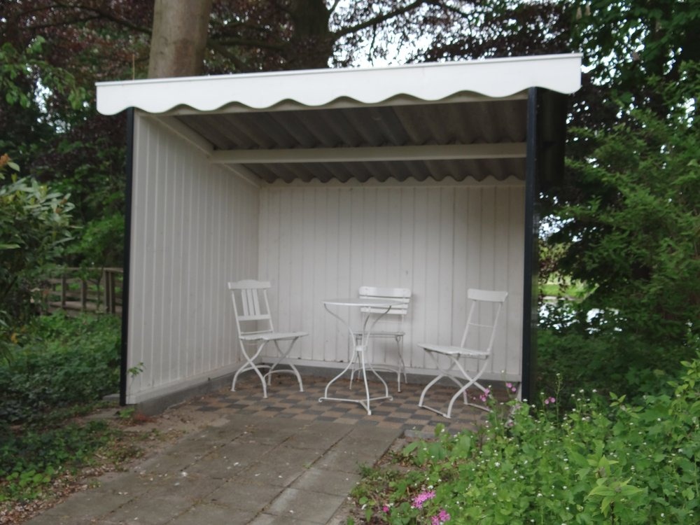
Two Pavilions Preserved
Of the original pavilions, only two have survived. Due to their historical significance as examples of a building type that has almost entirely vanished—owing to the fragility of the materials and the obsolescence of the sanatoria—they have been designated as a Rijksmonument (National Monument).
The structures are simple wooden buildings with a mono-pitched roof, three closed sides, and an open front. Both pavilions feature a tiled floor consisting of black and beige tiles in a random pattern with a geometric motif. Decorative bargeboards are fitted to the front: the eastern pavilion has an ornately carved trim, while the other features a simpler wave pattern.
Picture postcard from 1909
Restoration & Accessibility
The small halls were reconstructed in 2025. The original halls were in poor condition. The carpentry for the reconstruction was carried out by two students from the restoration carpentry program at the Gelderland Restoration Center in Velp. Volunteers and local businesses handled the rebuilding and finishing. The paintwork was executed in a historically accurate color scheme.
The pavilions can be viewed freely in the Vestingpark, directly behind the former St Bernardus sanatorium at ’t Zand in Bredevoort. The park is open to the public from sunrise to sunset.
For centuries, German merchants traveled through the Achterhoek with their heavy carts via the so-called Hessenwegen: ancient trade routes that connected the region with Germany and the Dutch trading cities. One of these roads ran from Bocholt via Aalten towards Zutphen and Doesburg. The Hessenwegen were of great importance for early modern trade in this region.
The term Hessenweg has been used since the 17th century. The traditional explanation refers to the merchants who came from the Landgraviate of Hesse-Kassel and the surrounding area. Within etymology, however, the name is explained differently: it is said to be a corruption of hers, meaning horse. These roads usually ran over high, dry sandy soils and along ridges.
Four major Hessenwegen ran through the Achterhoek. Three of them followed a northern route, from Vreden and Ammeloe via Groenlo, Rekken, and Neede, among others, to Deventer or Zutphen.
In the southern Achterhoek, a Hessenweg ran past Aalten. From Bocholt, this route crossed the current border at the Kesenbulte and continued via the Bodendijk, Dijkstraat, Landstraat, Berkenhovestraat, and the Romienendiek to De Radstake. From there, the road continued past Zutphen and Barneveld, with a branch between Halle and Zelhem towards Doesburg.
De Leste Stuver near Bredevoort
From the IJssel cities, the Hessenwegen crossed the Veluwe, converged in the Gooi, and continued to Amsterdam. The Hessenwegen had numerous branches. One of these ran near Aalten from the Romienendiek, via the Koningsweg, Hessenweg, past the Walfort, via Bredevoort and Winterswijk to Vreden.
For those living along a Hessenweg in the 19th century, the arrival of the Hessenkeerls was quite an event. On the windward side of the procession walked men with heavy clubs, dressed in their characteristic blue Hessenkiel: a shirt of fine linen, closed with copper hooks in the shape of lion heads and three small bone buttons. Decorated facings were applied to the chest and shoulders.
On the road, donkeys trudged through the loose sand, with a basket of woven willow twigs full of merchandise on either side. Once they arrived in a village, the men tied their donkeys near an inn or on the village square. The animals were fed and watered, while the men refreshed themselves at the village pump.
Afterward, the baskets were opened and the Hessians went from house to house peddling. Their merchandise included light glassware and soft straw hats. These hats were in high demand: as soon as the Hessians arrived, customers were already waiting for them to buy a new summer hat. The hats were elastic and therefore almost always fit. After a few hours, the Hessians moved on.
Pottenkeerls, musicians, and hannekemaaiers
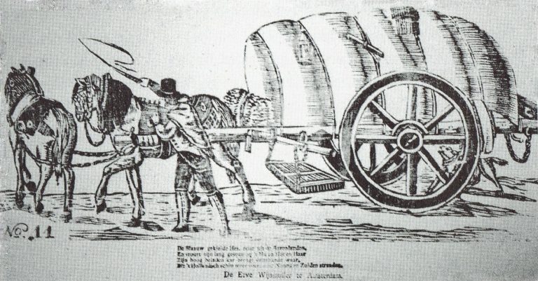
In addition to the Hessenkeerls, pottenkeerls also appeared on the Hessenwegen. They used heavy covered wagons that stood high on their wheels, the so-called Hessenkaoren, pulled by sturdy Holsteiner horses. The carts were full of Cologne pottery: gray or yellow-brown pots with blue decoration. The horses wore richly decorated harnesses, fitted and hung with copper decorations, so that their arrival could be heard from afar.
An image of a carter with his Hessenkar from around 1830, from the Popular Prints collection of Museum ‘t Oude Slot in Veldhoven, with the text:
The blue-smocked Hessian travels from the Uplands, And guides his long team with ‘Hu’ and ‘Hot’ and ‘Haar’. His high-laden cart brings many kinds of wares, Which the Dutch ship carries again to North and South shores.
In the spring, groups of German musicians traveled over the Hessenwegen to the Netherlands. Some bands were very well known in Amsterdam, Rotterdam, and The Hague. Although they presumably came from the same region, they were not called Hessians because they did not wear the Hessenkiel.
In addition, the hannekemaaiers came by in the summer: seasonal workers from Westphalia who helped in Holland with mowing grass and during the harvest. Women and children stayed behind at home to work on the land, while the men earned money elsewhere for the winter.
The end of the Hessenwegen
In the course of the 19th century, the significance of the Hessenwegen declined. In 1875, the last Hessians were seen near Zelhem, a meager group compared to former times. The Franco-Prussian War of 1870 and the subsequent industrial boom in the Ruhr area provided the Germans with a livelihood closer to home. Even many young people from the Achterhoek went that way to earn good money. With that, the Hessenwegen had had their day.
Older origins
Although the term Hessenweg was used from the 17th century, archaeological finds along these roads indicate that they had been in use for much longer. For example, in Aalten, at De Hoven near the Landstraat, traces of an 8th-century settlement have been found, including remains of sunken-floor huts, refuse pits, and spindle whorls. This is a strong indication that the later Hessenwegen built upon much older traffic routes, the so-called volkerenwegen (peoples’ roads).
It is therefore logical to assume that the village of Aalten partly owes its origin to this ancient peoples’ road. De Hoven was a favorable spot, because in the middle of the wild landscape of forest, heath, and marshes, there was a hill here, high and dry, directly on a through road. Moreover, a stream flowed at the bottom of the hill, providing fresh water.
Hessentocht
The memory of the Hessians still lives on. In 2011, a Hessentocht (Hessian Trek) was organized for the second time in the vicinity of Bredevoort and Aalten. During this trek, in which a historical caravan was simulated, an impressive ox cart took part: 2.60 meters wide, six meters long, and four meters high. In addition, three wagons participated, each pulled by three horses. Jan Oberink captured the trek on film and created the atmospheric impression below.
Acknowledgements
The content of this article is largely based on the article by G.J. Klokman (Zelhem, 1864), published in 1937. There are numerous other publications about Hessenwegen that present a different picture on some points. For this article, Klokman’s description was primarily chosen because his memories and observations specifically relate to the Hessenweg near Zelhem, the same route that also ran through Aalten.
Sources
G.J. Klokman, De Hessenwegen, in: Eigen Volk. Algemeen tijdschrift voor volkskunde (folklore) en dialect, 1937. National Library of the Netherlands
G.J. Klokman, De Achterhoekers, in: De Nederlandse volkskarakters, 1938. DBNL
The Driessen family is a lineage of textile entrepreneurs, originally from Bocholt, just across the border in Germany. Members of the family were active as textile manufacturers in Bocholt, Aalten, and Leiden. It is a Catholic family, which was included in the Nederland’s Patriciaat (Blue Book) in 1961.
The recorded lineage begins with Rutger Driessen, a weaver in Bocholt. In 1667, he paid taxes, but by 1672 he was considered too poor to be subject to taxation. Little is known about his son Johann Driessen (1663–after 1713) and grandson Gerard Driessen (1702–after 1738).
The family’s social ascent began with Gerard’s son Bernard Driessen (1731–1772). He traded in textiles, which he purchased from home-weaving farmers around Bocholt and sold in Holland. The family likely owes its rise to the fact that, due to their poverty, they could not become members of the Boomsidenambt, the guild of cotton weavers. Guild members were prohibited from trading fabrics that had not been woven by fellow members. As the Driessens were not part of the guild, they were not bound by this rule and could trade freely in cotton produced by home-weavers.
Thanks to this trade, Bernard became so prosperous that he was appointed schepen (alderman) of Bocholt, marking the family’s entry into the urban patriciate. However, he died at the age of 41 during a business trip to The Hague, before he could further strengthen his position.
Expansion of the Textile Trade
Two of Bernard’s sons continued the trade and expanded it significantly by employing hundreds of home-weavers: Peter Driessen (1756–1843) and Hermann Driessen (1765–1817). Initially, they worked together, but they later went their separate ways. Both brothers became very wealthy.
Both married daughters of Johann Jacob Hölscher, a member of the cotton weavers’ guild and also an alderman of Bocholt. Peter married Elisabeth Hölscher, and Hermann married her sister Gertrud. These marriages demonstrated that the Driessen family had by then integrated into the local elite. Consequently, Peter Driessen served as the second mayor of Bocholt for fourteen years (1797–1811) and, in 1813, he was a member of the council of the Rees district during the Napoleonic era. In 1841, in his advanced years, he received a Prussian distinction: the Ritter des Roten Adlerordens (Knight of the Order of the Red Eagle), 4th class.
From Trade to Manufacture
Peter Driessen had approximately 500 home-weavers working for him around Bocholt. These weavers were formally independent but reliant on the ‘reder’ (merchant-manufacturer) who supplied the yarn and financed the loom. The rise of centralised workshops—precursors to factories—made it possible to exercise greater supervision over production. Looms could henceforth be used continuously. In this way, the merchant became a manufacturer or ‘fabriqueur’.
Settling in Aalten
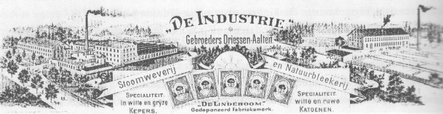
To protect Dutch industry from British imports, King William I introduced an import duty of 25% to 45% on cotton fabrics in 1823. This made exports from Bocholt to the Netherlands virtually impossible. To circumvent this levy, two Driessen cousins settled in Aalten, just across the border: Heinrich Driessen (1794–1879, son of Mayor Peter) and Anton Driessen (1797–1879, son of Hermann). In Aalten, they established various textile enterprises, including a steam weaving mill and a bleachery.
Over a period of more than 140 years (1826–1969), the Driessen manufacturers developed into the most significant employers in Aalten and the surrounding area. The factory buildings and private residences of the Driessens defined the village’s appearance. Until the second half of the 20th century, these manufacturers left a significant mark on the social and economic life of Aalten.
Sources
‘Geweven goed. De textielgeschiedenis van Aalten en Bredevoort’, H. de Beukelaer and J.G. ter Horst
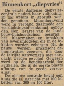
In the 1950s and 60s, so-called communal freezers emerged in the Netherlands, particularly in rural areas. These were facilities, often established on a cooperative basis, where residents of villages or rural districts could rent one or more lockers to freeze food.
The communal freezers provided a solution at a time when most households did not yet have their own freezer. Home-grown vegetables and fruit, or meat from home slaughtering, were primarily stored there.
In 1962, the Netherlands had approximately 700 of these communal freezers. However, their use declined rapidly in the 1970s, when the freezer became a common household appliance.
Locations
There were also communal freezers in the municipality of Aalten. Some well-known examples (provisional list, April 2025):
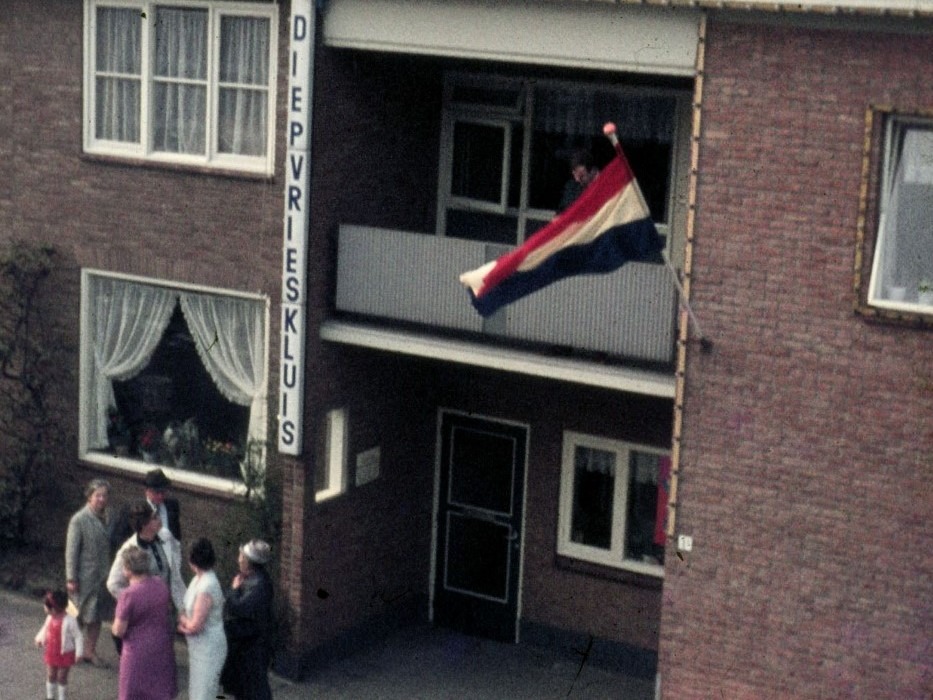
Aalten, Haartsestraat 1/1: A communal freezer was located beneath the premises of the Ten Have family. The building was demolished around 2003.
Ten Have’s freezer-locker plant, Haartsestraat, ca. 1969 (photo: L. Lievers)
Do you have any additions or corrections to this list, or photos of (vanished) communal freezers in Aalten? Do you know if anything has been preserved? Please let us know!
Newspaper reports
Dagblad Tubantia, 21 January 1958Zutphens Dagblad, 8 February 1958
Dagblad Tubantia, 9 December 1959Dagblad Tubantia, 19 April 1963
Dagblad Tubantia, 11 February 1966
Onnink’s communal freezer in Barlo, ca. 1969 (photo: willempie133)
Do you have family history in Aalten or Bredevoort? Are you curious about the address where your ancestors lived, were born or died? With the help of old archives and handy search methods, you can link historic house numbers to contemporary addresses. We’ve put together a step-by-step guide to help you get started!
In some old archives, the addresses of people were recorded. In the past, addresses consisted of the name of the core or rural district, followed by a house number. Partly because these house numbers have been changed several times over time, they cannot be directly compared with the current street name-house number combinations. 1
Below we explain step by step how you can trace an old address and how you can then trace it back to a contemporary location. Success not guaranteed!
Step 1: Find the old address
There are various (online) sources in which you can find out where a person lived, where he or she was born and where the death took place. Please note that some data is not yet public due to privacy laws. 2
WieWasWie.nl
The website WieWasWie.nl (‘Who Was Who’) contains information about births, marriages and deaths, among other things. But did you know that the search results often also contain a link to a scan of the original deed, including the address at the time?
Search by name and filter the results if necessary.
Click a relevant result, and then click Go to source on the right.
View the scan and note the house number.
Sometimes a series of scans will be displayed and you will have to look up the correct record in them. At the top of your screen is the Deed Number. Search the scans for the relevant deed and write down the house number.
Continue to Step 2.
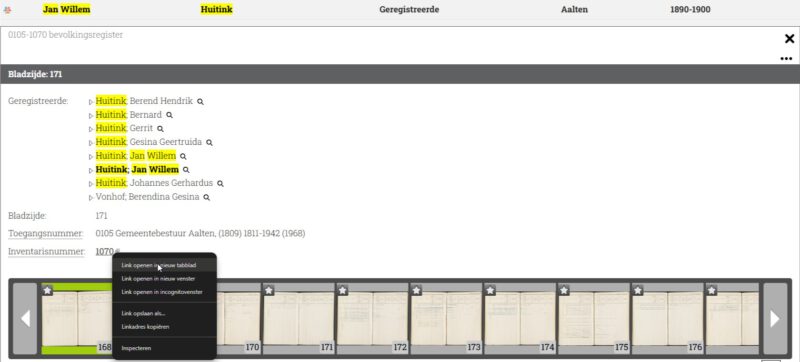
Heritage Centre Achterhoek and Liemers (ECAL)
On the ECAL website you can find scans of family cards from population registers in the Achterhoek. The public archive contains scans from the period from around 1823 to 1910.
Enter the Last Name and First Name . Tip: Use wildcards to find any spelling variants as well. 3
Enter the year of birth in both fields under Period and click on ‘Search’.
If necessary, filter by Plaats (note: Aalten, Bredevoort and rural districts fall under ‘Aalten’).
The right-hand column shows the period to which the family card relates. This is important because house numbers can vary from period to period.
Also check which core or hamlet the map relates to: Click on the relevant line and then on the Inventarisnummer (right mouse button, new tab). Remember the place and close the tab.
Open the family card scan.
Write down the house number and proceed to Step 2.
Régistre Civique (1811–1813)
During the French period, the Régistre Civique was introduced as a precursor to the population register. 4 Many persons included in this register also had their address (house number) mentioned.
Download the index of the Régistre Civique Aalten 1811-1813 (pdf).
Look in the PDF file to see if your ancestor is listed and if there is a house number.
If so, make a note of the house number and proceed to Step 2.
Older archives
Older sources, such as the Verpondingskohier from 1650 and the Liberale Gifte from 1748, often mention not only the names of the residents, but – if they lived on a farm – also the name of the farm. Many of these farms still exist today and can be found at oldaalten.nl/boerderijen.
Search the table for the correct house number. To make it easier to search, you can sort the table by the relevant year/period.
If the house number appears, you will find the current address there. If not, the house probably no longer exists. Surrounding house numbers may give you an idea of the approximate location.
Example
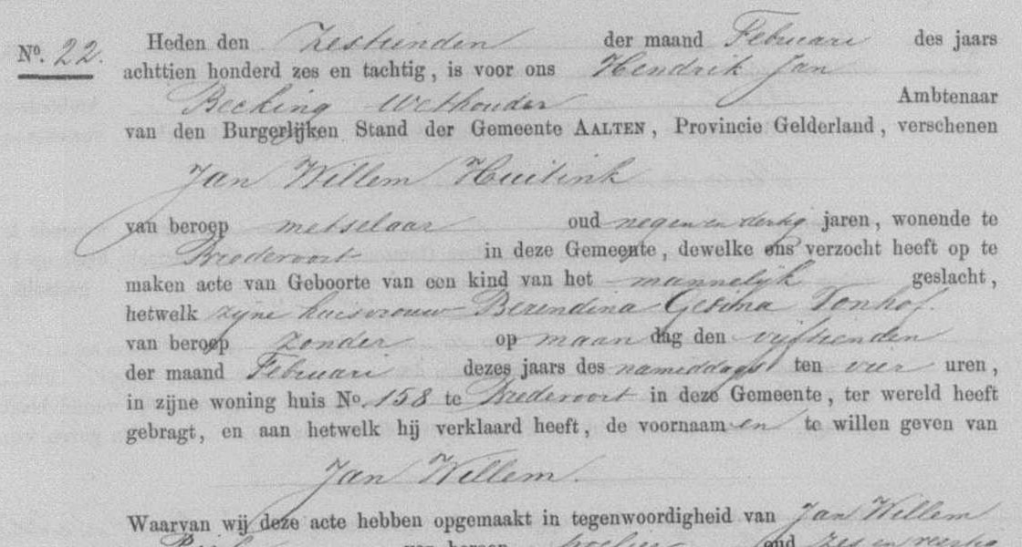
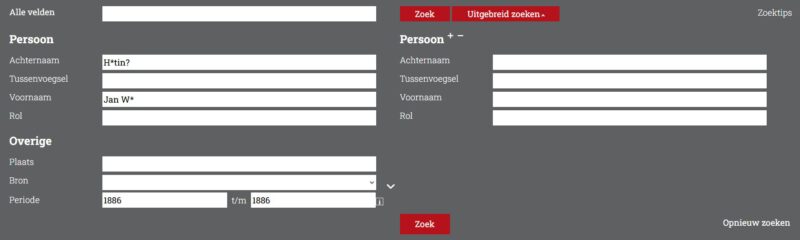
Suppose we want to know where Jan Willem Huitink was born in 1886 .
Search by ECAL
To search we use wildcards and enter the last name : “H*tin?“. We also find possible spelling variants such as Huiting, Huytink, Hoiting and Hoijtink.
Right click on Go to source and a new tab will open.
At the top is a Deed number (in this example: 22). You then have to look up the deed with that number in the scans that are shown below (in this example that is page 11; at the bottom right you will find deed number 22).
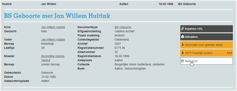
Here you will find the scan of the original birth registration, which shows that Jan Willem was born in house No. 158 in Bredevoort.
Here we find that Bredevoort 158 is now Koppelstraat 5 : View address.
The above methods are not exhaustive, because in the archive world several roads lead to Old Aalten. For the overview, we have outlined the most important steps and done our best to explain everything as clearly as possible. We hope this helps you further. Good luck with your search!
In 1937, G.H. Rots described in a series of articles how things were done in Aalten in former times. Among other things, he wrote about the customs when a farmer moved:
“On the rare occasion that a farmer moved, this took place on ‘Saint Peter’s Day,’ February 22nd. All belongings were loaded onto the neighbors’ wagons, and the entire procession moved from the old house to the new or different farmstead. The neighbor women had already gone ahead to the new home, had cleaned it, and had lit the fire. In the local dialect, this was called ‘vuur beün’ (preparing the fire).”
When the new residents arrived, the coffee had already been brewed, and the newcomers could immediately refresh themselves with a nice cup of coffee. The neighbors helped that day; one person would put something here, another there—it was a scene of immense activity. To top it all off, the ‘housewarming meal’ followed later, where there was certainly no shortage of spirited drinks.”
A moving procession
Source
‘From Aalten’s verleden’, by G.H. Rots, Aaltensche Courant, 12 & 19 November 1937 (via Delpher: part IV)
Several theories circulate regarding the origin of the name Aalten. But what are they based on and how credible are they? Old Aalten delved into history to discover more about this.
We begin with the oldest historical mentions of Aalten, as these may contain clues about the origin of the name. Next, we examine what toponomy (the study of place names) can teach us about this. We then discuss several theories regarding the origin and meaning of the name Aalten and conclude with our findings.
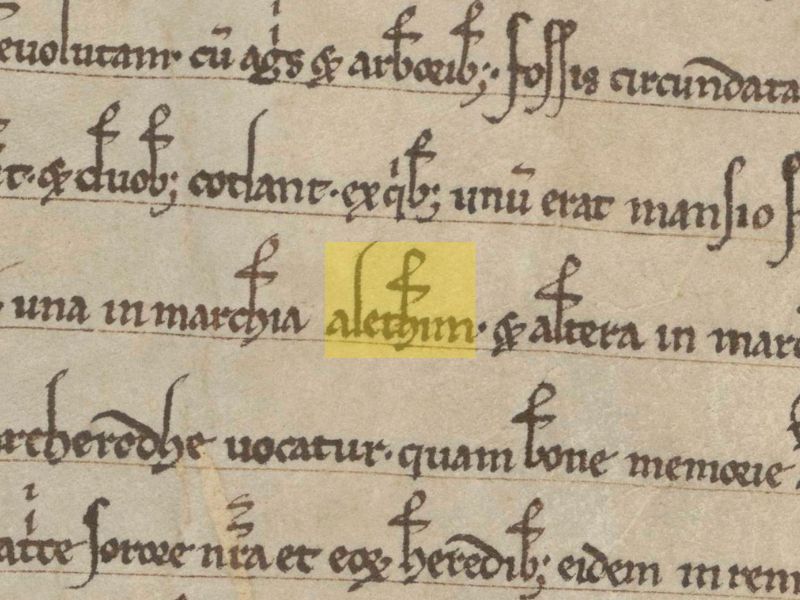
Deed from 1234, in which Aalten is mentioned twice as ‘Alethim’
Earliest mentions
There are several medieval documents containing a reference to Aalten, with varying spellings. The best-known mentions are Aladna and Aladon, after which the Aladnaweg and a school are named. Below is an overview of historical mentions, including a reference to the oldest known source.
828
A charter from 828 describes how a certain Geroward donated all his possessions, including those in Aladna, to the St. Martin’s Church in Utrecht on February 7 of that year. Little is known about Geroward’s identity, but he was presumably a Frankish nobleman in the service of the Carolingian Emperor Louis the Pious, son of Charlemagne.1
1138/ 1139
In 1138 or 1139, Godschalk of Versnevelde (Varsseveld), with the consent of his brother Count Gerhard (II) of Lohn, enters into an exchange agreement with the canons of the St. Mary’s Church in Rees. He transfers an estate in Megchelen near Gendringen, including associated hunting rights, two fields, a meadow, and nine serfsof both sexes. In exchange, he receives a property in Alethnin, with all yields and seven serfs.2
1152
In 1152, Count Godschalk (II) of Lohn, son of Gerhard II, reached a settlement with Bishop Frederick II of Münster. Godschalk claimed authority over the parishes of Lon, Winethereswik, Aladon, Versnevelde, Selehem, and Hengelo on the basis of his comital title. The bishop held a different view, after which it was formally established that Godschalk did not hold these territories in his own right, but was to administer them as a liegeman of the bishop.3
1188
In 1188, during the reign of the Holy Roman Emperor Frederick I, priest Everhardus, chaplain to Count Henry of Dalen and Diepenheim, compiled an inventory of Henry’s feudal (vassal) and allodial (free) possessions. The feudal properties were recorded under the parishes to which they belonged, including Ecberghe, Gronlo, Winterswic, Nehde, Ghesterne, Lochem, Almen, Dotinchem, Zelhem, and Althen.4
1234
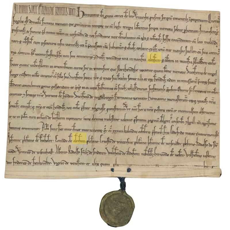
In 1234, Count Herman (I) of Lohn, Lord of Bredevoort, together with his brothers Henry, provost of Zutphen, and Otto, canon of St. Gereon in Cologne, as well as his brothers-in-law Werner van Herden, Sweder van Ringelberg, Herman Werecen, Herman van Munster and their spouses, and all their further heirs, entered into an exchange with the Bethlehem Monastery. In this agreement, the monastery receives from the count, among other things: duabus warandiis, una in marchia Alethim et altera in marchia Silvolden (two hunting grounds; one in the mark of Aalten and the other in the mark of Silvolde). Witnesses include the parish priests Johannes from Bocholte, Conradus from Alethim, Ernestus from Winterswic, and Johannes from Versevelde.5
1254
In 1254, mention is made of the “curtis Grevinkhof sita in parochia Alethe“ (the estate Grevinkhof, situated in the parish of Aalten): Gotscalco de Reme receives from Otto van Loon in castle-fief the curtis Grevinkhof in Aalten, with the mill and further appurtenances, with the exception of the timber court. Present here Gerardus Canoninicus “frater domini G. de Reme”.6
1313
In a register of churches belonging to the Diocese of Münster from the year 1313, the following parishes, currently located in the Netherlands, are mentioned: Alten, Dinxperle, Eiberghe, Gheesteren, Grolle, Hengelo, Neede, Seelfwalde, Selehem, Versevelde and Wynterswik.7
1386
Derich Willemssoen van Lyntloe has been granted Varenvelde in parish Alten, sabbato na Briccii ep. (17 November) 1386.7
1409
Derk van Linteloe and his children Derk and Herman, declare to have sold to Johan Rensynck the estate ten Nygenhues, located in the hamlet of Lynteloe under Aelten and held in fief from the Lordship of Borculo, 1409 July 24 (in vigilia beati Jacobi apostoli maioris).8
Toponymy and sound development
Toponymy, or the study of place names, is a branch of linguistics that studies place names and seeks to explain their origins.9 A generally accepted principle within toponymy is that the sound development of a name is more reliable than its spelling, as written mentions in pre-modern times were inconsistent and influenced by scribes, dialects, and time-bound conventions. The sound of a name, by contrast, usually remains more consistent and therefore offers better insight into the original pronunciation and meaning.
Now, we are not toponymists, but when we view the sound development of the earliest mentions of Aalten chronologically, we believe we recognize a pattern:
For a period of four centuries (9th-13th century), these mentions consist of three syllables, starting with ‘ala’ or ‘ale’, followed by a d or t, and in most cases ending with an n. Although the spelling varies, the sound structure remains largely consistent. From the 13th/14th century onwards, we see that the second syllable gradually disappears and that the name corrupts into Althen/Alten/Aelten/Aalten.
Theories on origin and meaning
Below we discuss the best-known theories regarding the origin and meaning of the name Aalten.
Place on a hill
A frequently cited theory states that the name Aalten is derived from the Latin altus, meaning ‘height’. This explanation seems primarily based on the fact that Aalten originated on a hill and the phonetic similarity between altus and Aalten. However, there is no historical or linguistic evidence for this theory. Furthermore, this explanation does not take into account the sound development in the oldest known mentions of the name.
Homestead by the altar
Another theory suggests that Aalten was inhabited around 150 BC by Angles from the area that is now Berkelland. According to this explanation, the name is derived from the Anglian ael (altar, place of sacrifice) and thun (garden, enclosed yard). This would lead to Aelthun, or ‘homestead by the altar.’10 This explanation is also speculative and does not fit the sound pattern of the medieval mentions of the name.
Plant or tree name
In Gelderse plaatsnamen verklaard, Gerald van Berkel states that the name Aalten may be related to a plant or tree name and refers to the Old Norse alað (nourishment, food), aldin (edible tree fruit), or alda (fruit-bearing oak).11 Although there is no direct evidence for this explanation, it does fit the sound pattern of the medieval mentions.
Place by the water
In Prehistorische waternamen Maurits Gysseling suggests that the name Aalten is derived from the Indo-EuropeanAlatanā, meaning “situated in a bend of a stream”.12 In the case of Aalten, this would refer to the Slingebeek. Van Berkel, however, calls this theory far-fetched in Gelderse plaatsnamen verklaard.
Place name researcher Bas Kloens disagrees. In his study on place names and their origins, Valkuilen in de Plaatsnaamkunde, he states that it is actually “abundantly clear” that Aalten, like many other similar place names, owes its name to its location on a watercourse or stream.13
Conclusion
No single theory regarding the origin of the place name Aalten can be supported with hard evidence or completely ruled out. It remains, therefore, largely a matter of speculation. Nevertheless, we lean towards the theories of Gysseling and Kloens, who state that Aalten owes its name to its location on a watercourse, namely the Slingebeek.
Furthermore, despite Van Berkel’s skepticism, a connection with the Indo-European Alatanâ, which bears a strong resemblance to Aladna, seems plausible to us.
In short, although not scientifically proven, our nomination for the most plausible explanation for the origin and meaning of the name Aalten goes to Place by the water / situated in a bend of a stream.
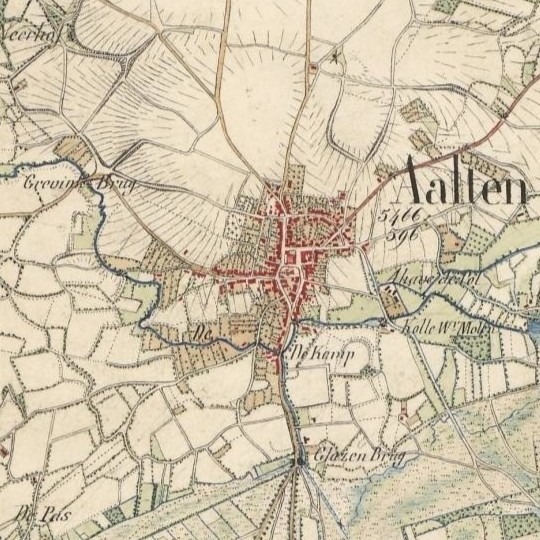
The village of Aalten, situated on a hill by the Slingebeek (fragment of a topographical map from 1845)
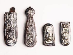
Archaeological finds indicate that the early inhabitants of Aalten were already burying their dead around 800 AD in a burial field on the current Damstraat. During excavation work in the late 19th and early 20th centuries, traces of a Merovingian-Frankish burial field were discovered there. Notable finds, such as spearheads, stirrups, a shield boss, and silver belt links, suggest that a warrior may have been buried here.
On De Hoven, traces of habitation from the same period have been found, consisting of various so-called sunken huts – rectangular pits that served as work or storage spaces. Pottery fragments found here correspond with the finds from the burial field on the Damstraat.
The Christianization of Aalten
Following the subjugation of the Saxons by Charlemagne around 785, the Christianization of Aalten and the surrounding area began. Missionary Liudger, later Bishop of Münster, played a significant role in the founding of churches in the region, presumably including the first church in Aalten.
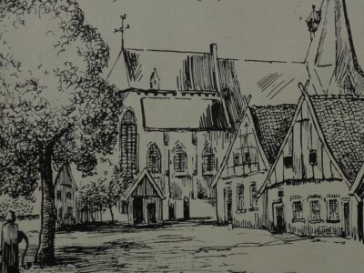
This church, originally likely a simple wooden chapel, was founded on a strategic and symbolic site: the elevated location where the current Old St Helen’s Church stands today. This site became the religious and social center of the community.
Archaeological research has shown that the residents of De Hoven abandoned that site around the year 1000. It is possible that, after converting to Christianity, they decided to live closer to the recently founded church to enjoy the protection of the faith. From that time on, the deceased were also presumably buried in and around the church.
Churchyard
A churchyard developed around the church, which played an important role in the life of the community during the Middle Ages. The churchyard in Aalten was originally much larger than the current plot surrounding the Old St Helen’s Church. It served not only as a burial ground but also as a place for social and religious gatherings. In those days, people even lived around or on the churchyard, often officials such as sextons or clergy who were directly involved with the church.
In recent centuries, skeletal remains have been frequently encountered during excavation work in the ground around the church, such as on the Köstersbulte, the path along Elim, and also on the Kerkstraat, where buildings now stand. The original burial ground around the church was therefore much larger than the current site on which the church stands.
Until the 19th century, the deceased were primarily buried in and around the church. Burial inside the church itself was reserved for people of status, such as clergy, nobles, and benefactors. It was believed that a grave within the church guaranteed a better position in the afterlife. However, most people were buried in the churchyard surrounding the church. Individual tombstones were rare in the Middle Ages; many people were buried in unmarked graves.
Health Risks
However, burial inside the church brought significant problems. A lack of space and the decomposition of bodies led to health risks; churchyards became overcrowded, and the situation became untenable.
Subsidence in the floor occurred regularly within the church, and the owners of the respective graves often failed to carry out the necessary repairs. The odor of decay in the pews near the hole in question was sometimes unbearable for weeks, especially during the summer months.
Aalten Market with church and ‘bone hall’, ca. 1740 – drawn by Piet te Lintum
Epidemics such as the plague exacerbated this problem. Consequently, a regulation was established stating that churchwardens, in cases of negligence, were permitted to contract out the necessary repairs, whereby the respective plot would revert to the church.
The condition of the burial ground around the church was also often poor. Because burials had not been conducted at a sufficient depth for a long time, bones frequently came to the surface. A bone collector would gather these remains from time to time, for two bushels of rye per year, and cast them into the bone hall (also known as a charnel house), a small building in the churchyard on the Market side. When the supply became too large, it was cleared away.
Royal Decree of 1827
In 1827, King William I decreed by law that, from 1829, cemeteries had to be established outside built-up areas. For many people, this was a major step—to break with all traditions and leave the dead outside the village “just anywhere in the ground.”
The practice of burial in and around the church symbolized an era in which religion, death, and community were closely intertwined. The ban on this practice was a turning point that not only benefited public health but also marked a shift in how death was handled: individual graves were given more space, more funerary monuments appeared, and cemeteries were landscaped.
Christiaan Caspar Stumph, Mayor of Aalten since 1811, was annoyed by burials within the village. In 1818, he therefore had an ‘outside cemetery’ created for himself and his family on his estate, Het Smees. His son Abraham Anthony was the first to be buried here, followed by Stumph himself in 1820. In total, seven people rest on this unusual burial mound, which is still visible on the Nannielaantje in Aalten.
Following the royal decree of 1827, a site on the Varsseveldsestraatweg in Aalten was designated as a cemetery. Due to the growth of the village, this cemetery became increasingly enclosed by the early 20th century. In 1923, the Berkenhove cemetery was put into use. Although the Old Cemetery has since taken on the function of a memorial park, it is still sporadically used for the interment of the deceased in existing graves.
When the cemetery on the Varsseveldsestraatweg was established, the Catholic community was given its own section across the street, on the corner with the Molenstraat. This cemetery became full after only thirty years, after which a new Roman Catholic cemetery on the Piet Heinstraat was put into use in 1868. The small old cemetery later took on the function of a public green space.
On the Haartsestraat in Aalten, just outside the village, lies the Jewish cemetery of Aalten. Although the site officially became the property of the Jewish community in 1852, there are indications that the cemetery had been in use since approximately 1820. There are about seventy tombstones on the site, varying in age and design. At the entrance on the Haartsestraat stands a metaheer house, a ritual building used for the cleansing of the deceased according to Jewish traditions.
When the Catholic cemetery on the Varsseveldsestraatweg became full, textile manufacturer Anton Driessen donated a piece of land on the current Piet Heinstraat in 1868 to be laid out as a cemetery. He also donated an iron Calvary cross and an iron gate. The bier house dates from 1888. A century later, this cemetery also became full. From 1960 onwards, Catholic deceased were therefore buried in the new Roman Catholic section of the Berkenhove cemetery.
After the Old Cemetery on the Varsseveldsestraatweg became full, the ‘Berkenhove’ cemetery on the Romienendiek was put into use in 1923. The original section is enclosed between the Romienendiek, the Barloseweg, and the Koningsweg. Over the years, the cemetery has been regularly expanded. In 1960, a Catholic section was added because the Roman Catholic cemetery on the Piet Heinstraat was full. A modern funeral center and crematorium are located at Berkenhove.
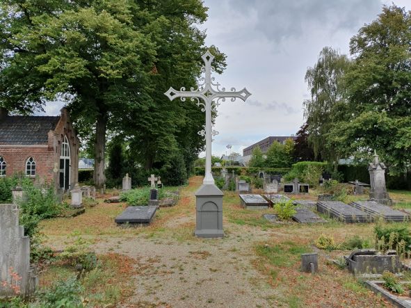
The Old Cemetery on the Prins Mauritsstraat was established around 1830, simultaneously with the adjacent Jewish Cemetery. The site became available after the dismantling of the fortifications on the eastern side of the town. In 1925, a new entrance gate was installed, and a bier house was built a few years later.
Bredevoort once had two Jewish cemeteries. The oldest was located on the former castle grounds behind Hozenstraat 5. In 1953, this site was sold to the municipality of Aalten for housing construction. The remains and tombstones were then transferred to the second cemetery on the Prins Mauritsstraat.
The Jewish Cemetery on the Prins Mauritsstraat was established around 1830, simultaneously with the adjacent general cemetery. The last Bredevoort Jews to be interred in this cemetery were brother and sister Levi and Sara Sander. Both died in 1938, shortly after one another. The cemetery is not accessible to the public.
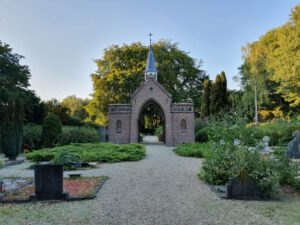
The Kloosterhof cemetery on the Kloosterdijk in Bredevoort was established in 1862-1863 and originally served as a Roman Catholic cemetery. The oldest, centrally located part has a symmetrical layout with a characteristic entrance gate, a bier house, and a Calvary cross. In the 1980s, the cemetery was expanded with a general section. A mortuary was also erected in 1989.
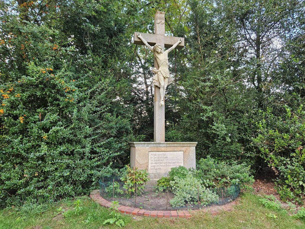
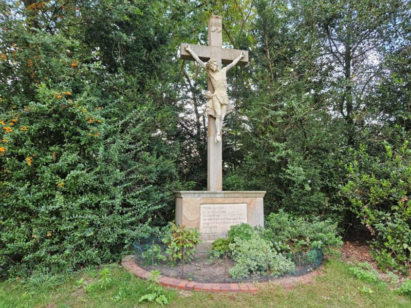
Cross on the ‘Kruisberg’ near the former Cross Chapel, Hemden (Photo: Remco Neerhof)
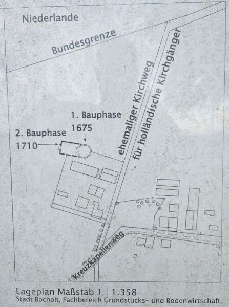
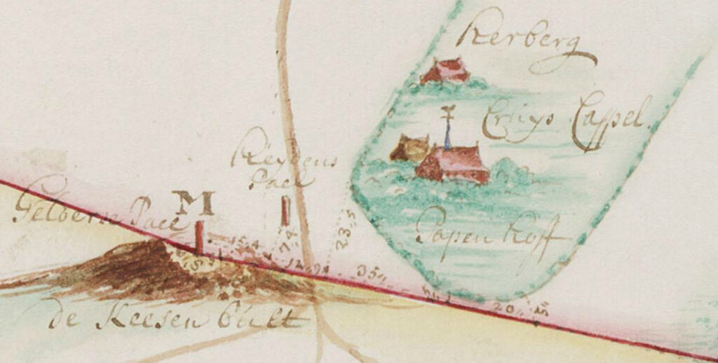
The ‘Kruiskapel’ (Cross Chapel, or German: ‘Kreuzkapelle’) in Hemden was a ‘refuge chapel’ for the Catholics of Aalten and Bredevoort. During the height of Calvinism (1675–1821), they were forbidden from practising their faith in their home region. The chapel stood in the German village of Hemden, two hundred metres beyond the current ‘green’ border near the Kesenbult, at the end of the Kiefteweg.
Missionary Outpost
From 1672 to 1674, Christoph Bernhard von Galen, the Prince-Bishop of Münster (1650–1678), waged war against the Dutch Republic, supported by King Louis XIV of France. Von Galen, nicknamed ‘Bommen Berend’ (‘Bombing Bernard’), was forced to withdraw from Dutch territories following the Peace of Cologne in April 1674. However, the Catholics remaining in the area were still prohibited from owning their own churches or holding religious services. To provide the Catholics of Aalten and Bredevoort with the opportunity to practise their faith, Von Galen ordered the construction of nine missionary outposts along the border, one of which was the Cross Chapel in Hemden.
Construction of the Cross Chapel
Initially, Catholic services in Hemden were held in a barn on the Leicking estate, which had been converted into a house of prayer. In 1675, by order of Von Galen, the Cross Chapel was built on the Reyerding estate. The chapel, dedicated to the Holy Cross, was constructed under the leadership of Jesuit Father Ernst Ignatius Busch, who served as the parish priest for the Aalten and Bredevoort congregations from 1672 to 1674.
The chapel was an octagonal, largely wooden structure and became the religious centre for the exiled Catholics of Aalten and Bredevoort. Between 1710 and 1714, the chapel was restored and enlarged into a rectangular shape.
The ‘Kruisberg’ (Cross Hill)
Around the same time, the ‘Kruisberg’—a small hill—was created near the chapel, upon which a cross was placed. This cross faced the chapel and stood on a pedestal bearing the following inscription (translated from the Middle Dutch):
What you see here is an image of Christ and not He Himself, therefore, worship neither wood nor stone, but direct your heart only to Christ.
This inscription was intended to refute the Protestant accusations of the Reformation era that Catholics were worshipping idols through their figurative representations of Christ and the saints.
Church Life
By 1751, the parish of the Cross Chapel numbered approximately 27 German and 451 Dutch Catholics. Every Sunday, on Catholic feast days, and for family events such as baptisms and weddings, the Catholics from Aalten and Bredevoort made the journey to the chapel, often via the present-day Bodendijk and Veenhuisweg. According to local tradition, the worshippers travelled in their work clothes and carried their tools with them so as not to draw attention as churchgoers.
Transcriptions of the baptismal and marriage registers of the Cross Chapel are available on the Genealogiedomein website and are valuable sources for genealogical research.
The Restoration of Catholicism in the Netherlands
From 1798, the people of Bredevoort, and from 1799 those of Aalten, were once again granted the right to practise the Catholic faith freely in their own country. They established their own churches in Bredevoort and Aalten, which led to a decline in the number of Dutch visitors to the Cross Chapel. By 1800, only a few German believers remained, mostly attending on Sundays and feast days.
In 1821, Pope Pius VII decreed that the parishes of Aalten, Bredevoort, and other surrounding areas were to be assigned to the ‘Dutch Mission’. As a result, only five German families remained as members of the Hemden parish. The Cross Chapel had thereby lost its original purpose.
The End of the Cross Chapel
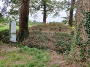
On 16 July 1821, Pope Pius VII formally declared the separation of the Dutch Catholics. Two years later, in 1823, the Cross Chapel was demolished. The parish was dissolved and relocated to the nearby Bocholt rural district of Barlo, a few kilometres south-east of Hemden. All that remains today to commemorate the chapel is the Kruisberg, with its Baroque cross and a stone memorial plaque.
In total, seven parish priests served at the Cross Chapel. Although the chapel itself has vanished, the Kruisberg and its cross remain as a reminder of the religious life of the Catholics from Aalten and Bredevoort during a time of oppression and persecution.
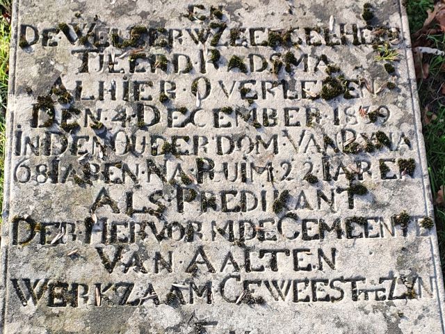
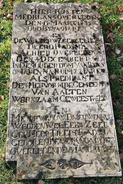
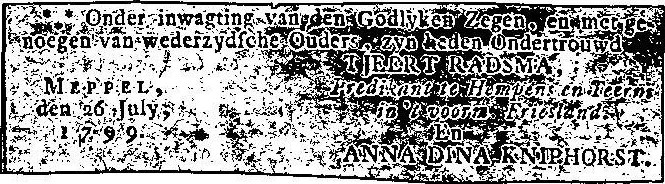
Tjeerd Radsma was born on 20 February 1772 in Harlingen, the son of Hermanus Radsma and Aafke Steffanij. He married Anna Dina Kniphorst on 11 August 1799 in Meppel. Following her death in 1805, Radsma remarried on 6 October 1808 in Leeuwarden to Doedtje Nieuwenhuis, who had previously been married to Heert Jans Kingma.
In 1812, Tjeerd Radsma was registered as a resident of Hempens, near Leeuwarden. He was the minister of Hempens and Teerns at the time. It is also noted that he had four children at that point. Three have been identified, all from his first marriage:
Johanna (Hempens, 1800 – Aalten, 1847)
Aafke (Hempens, 1801 – Aalten, 1824)
Anna Dina (Hempens, 1805 – Meppel, 1806)
To Aalten
In 1817, at the age of 45, Radsma moved to Aalten as a minister. Five years later, on 11 August 1822, he commemorated his 25th anniversary in the ministry. On this occasion, he delivered a sermon based on 2 Corinthians 5:9. The opening sentence of the sermon read: “Every individual’s life presents times and days that are more remarkable than others and to commemorate these – provided their multitude does not weaken the impression too much – can be very useful.”
Tjeerd Radsma passed away on 4 December 1839 in Aalten, at the age of 67. He was buried in the Old Cemetery on the Varsseveldsestraatweg. His gravestone is one of the oldest remaining funerary monuments there. Also interred in the same grave are his widow, Doedtje, who died in 1855, and her granddaughter, Maria Elizabeth Dodina Bianka Lans, who died in 1835 at the age of eight. Maria’s mother was Janke Kingma, a daughter of Doedtje from her first marriage.
Grave Tjeerd Radsma
Banns of marriage for Tjeerd Radsma & Anna Dina Kniphorst, 1799Death of Rev. Tjeerd Radsma, 4 December 1839
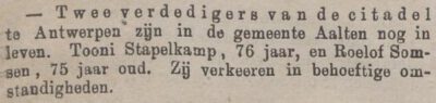
Toni Stapelkamp was a farmer’s son from the Heurne in Aalten. He served in the National Militia and was decorated for his participation in the Ten Days’ Campaign and the defence of the Citadel of Antwerp.
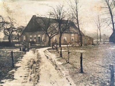
Stapelkamp Farm, 1920s (Photo courtesy of A. Stapelkamp)
Toni (also spelled Tonij and Antonij) Stapelkamp was born on 30 July 1807, during the French period. He was the third son of Hendrik Willem Stapelkamp and Johanna Elisabeth Slotboom, and the great-great-grandfather of our current mayor, Anton Stapelkamp. Toni was the last Stapelkamp born on the farm of the same name in the Aalten Heurne.
In 1814, when Toni was only seven years old, his father passed away. This likely caused the family’s financial circumstances to deteriorate significantly, especially during a time when people were already suffering under the negative consequences of French rule. Stadtholder William V, the Lord of Bredevoort, had lost his rights, and consequently, Drossaard Van Palland had lost his position. The Stapelkamp farm was sold during this period.
Profession
As the youngest son, Toni had to find employment elsewhere at a very early age. Without the breadwinner, the small-scale Stapelkamp farm could not have fed so many mouths.
According to the 1809–1823 population register, he lived and worked at that time as a farmhand for Derk Jan Haartman on the Haartman farm in the Haart. He was at most fifteen years old then and may have left home as early as age twelve or thirteen. His older sister, Engelina, also lived and worked there as a maid.
It is notable that this Haartman sold his farm to the Te Roele family and emigrated with his family to the US in 1846 on the SS Hector. The Te Roele family still lives on the farm in 2022.
In the 1823–1838 population register, Toni is listed, still as a farmhand, with Jan Hendrik Drenthel on the Drenthel farm, also in the Haart, but now without his sister Engelina. In the population registers of 1838–1861, Toni is first listed as a labourer and later as a farmer (1860–1890).
Military Service and Awards
According to the Decree of 15 February 1827 published in the Provinciaal Blad van Gelderland, Toni was summoned to appear as a reservist of the National Militia at the ‘Government Building’ in Arnhem on 27 February at 08:00. Together with 223 other men—including five other men from Aalten—he had to serve in the 7th Infantry Division.
He had to report to his corps on 1 March. Municipal authorities were required to ensure that they were provided with leave passes. In addition to this 7th Infantry Division, 373 other men from Gelderland were called up for a 13th Infantry Division, also including five men from Aalten, a 4th Artillery Battalion with 59 men, and a 1st Field Artillery Battalion with 28 men.
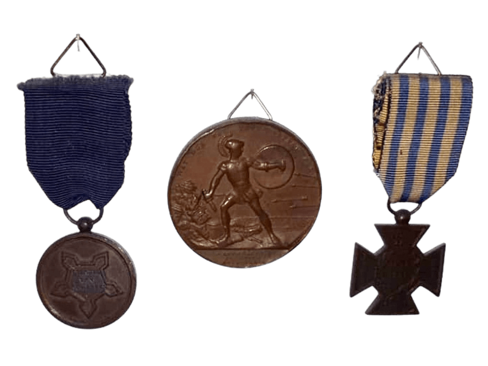
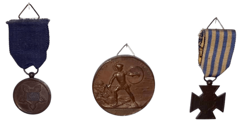
Toni received decorations for his service during the Belgian Revolution: specifically, his participation in the Ten Days’ Campaign in 1830 (the Bronze Cross) and the defence of the Citadel of Antwerp against French troops in 1832 (the Citadel Medal and the Medal of the Commission of Merit).
Toni Stapelkamp’s decorations: the Citadel Medal and the later issued (large) personalized medal for the Commission of Acknowledgement; on the right, the Bronze Cross of the Ten Days’ Campaign (photo submitted by A. Stapelkamp)
Marriage and Family Life
After his military career, Toni settled on the Lichterink farm in Barlo, where he worked as a farmhand. In 1839, he moved to the Wissink farm in Miste, also as a farmhand. He married the nearly 33-year-old Janna Geertruid Westerveld (1809–1887) from Dinxperlo on 7 May 1842, at the age of nearly 35. She was the widow of Derk Lammers.
The marriage certificate, drawn up by Mayor Roelvink, states that Toni and Janna were farmers. The certificate also notes that Toni, Janna, and three of the four witnesses—including his brother and Garrit Hendrik—could not read or write, “having never learned to do so”, as was the case for many in those days.
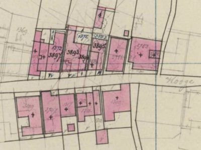
Fragment of the cadastral map, 1884 (top left plot 3897, formerly 1372)
Toni moved in with her in 1842 at the residence on the Hogestraat (currently number 26). In addition to Toni and Janna, two daughters and a son from Janna’s first marriage were registered at this address: Aleida, Rebekka Berendina, and Evert Hendrik Lammers. Furthermore, Janna’s former mother-in-law, Elisabeth Loos, and Aleida Klompenhouwer, a seamstress, were listed as residents.
Toni and Janna had three children: Dora Willemina (1843–1924), Gerrit Jan (1846–1848), and Gerrit Jan (1849–1935), the great-grandfather of our mayor. In 1855, a stillborn child was born. From 1875, his daughter-in-law Hendrika te Sligte lived with them, as did the first three children.
In 1853, Janna had a will drawn up. A private deed shows that in 1862, Toni purchased “a small house with grounds, standing and situated on the Hoogestraat within the village of Aalten and known there cadastrally in Section I number 1372, one rod and thirty ells in size” for 150 guilders. One of the sellers was Jan Hendrik Schepers, who was imprisoned in Leeuwarden at the time. The mentioned plot concerns Hogestraat 26.
Later Life and Death
Zutphensche Courant, 30 November 1882
In a report dated 30 November 1882, Toni was mentioned as one of the last two surviving defenders of the Antwerp citadel. It is noted that both were living in “needy circumstances.” This is remarkable, given that his thirty-three-year-old son, Gerrit Jan, was living with him with his wife, and he surely must have had an income.
Toni outlived all his brothers and passed away on 8 December 1889, at the age of 82. The death registration was carried out by his naobers (neighbours) Derk Jan Heusinkveld (Hogestraat 28) and Berend te Slaa (Hogestraat 24). His wife, Janna, had already died in 1887 at the age of 78. Despite their late marriage, they still celebrated their golden wedding anniversary. That was something not many were granted in the nineteenth century on the impoverished Achterhoek countryside.
Toni must have heard about the ecclesiastical developments surrounding the Secession and the first seceded congregation in 1843. In the 1838–1851 population register, he was listed as Reformed, but in all subsequent records until his death, as Dutch Reformed. Around 1850, several Stapelkamp family members left with other seceded Achterhoekers for Iowa, Wisconsin, and Michigan in the United States.
In August 2024, archaeological research was carried out on a site at De Hoven in Aalten, shortly before apartments are built. This research, carried out by members of the antiquities association ADW led by archaeologist Willem Doodeheefver, provided valuable insights into the early medieval history of Aalten.
The finds, which include remains of hut bowls, waste pits and metal objects, offer a unique insight into life around the year 900 AD. Previous excavations in this area, in 1982 and 1892, had already found traces of a so-called Frankish-Merovingian settlement.
Hut bowls
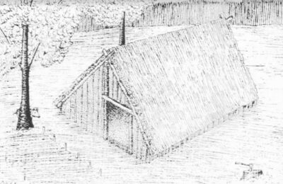
This is what the Aalten hut bowl could have looked like (sketch made by Willem Doodeheefver)
The most striking finds during the excavations in 2024 are the remains of some hut bowls, which became visible due to dark discolorations in the soil. A hut bowl was a half-buried, rectangular building, about three meters wide and four meters long. The pit was 0.5 to 1 meter deep and had no above-ground walls; The roof construction rested partly on ground level. This construction method provided shelter from the summer heat and provided relative warmth in winter.
Hut bowls served as craft rooms, usually on a farmyard. They were used for activities such as weaving, woodworking, metalworking or working bone. Slag was found at one of the hut bowls found at De Hoven, remnants of molten rock. This may indicate that the hut may have served as a blacksmith’s shop.
Waste pits
Several waste pits have been found scattered around the site. The waste left behind by the residents at the time provides valuable information about their daily lives, utensils and the dating of the hut bowls. Among other things, shards of pottery were found in the waste pits, dated around the year 900 AD.
1100 years of habitation
The finds give a picture of the landscape as it looked more than 1100 years ago. A favorable circumstance is that the soil of De Hoven has remained largely untouched during the past thousand years. The name ‘De Hoven’ refers to the gardens that were here for centuries, and the area has remained largely undeveloped to this day.
This and earlier archaeological finds on De Hoven, but also on the Damstraat, confirm that people were already living in Aalten 1100 years ago. This period coincides with a mention of a place that was mentioned in a document from 828 Aladna .
Why this place?
The choice of this place of residence in the early Middle Ages is easy to explain. Aalten is located on seven slopes that were formed in the ice age. De Hoven is located on one of the higher, dry and safe parts. For the residents, it was only a short walk to the Slingebeek, where they could get water and fish. De Hoven is also a stone’s throw from the Landstraat. It is possible that this was already an important traffic route in the Achterhoek at that time, an area that was still quite empty and largely unexplored at the time.
Ret. Lieutenant Colonel and former member of the Provincial Council of Gelderland
Jacobus Wilhelmus van Hopbergen was born on July 16, 1817, in Ravenstein (municipality of Oss), son of retired lieutenant Diederik Christoffel Hendricus van Hopbergen and Maria Wilhelmina Frank. His parents presumably settled at Prinsenstraat 10 in Bredevoort around 1820.
After his training and compulsory military service in the 3rd Infantry Regiment in Leeuwarden, where he reached the rank of titular lieutenant colonel, he married Adriana Pieternella Dillié (1816–1888) in Leeuwarden in 1848. They had four daughters; a son died shortly after birth.
His older sister Louiza Wilhelmina (1810–1906) had married Lieutenant Colonel Jan Jacob Thomson (1784–1858) in 1837. They lived in his parental home in Bredevoort.
Settling in Aalten
In 1869, the Van Hopbergen family settled in Aalten, at the beginning of the Hogestraat. Shortly thereafter, Van Hopbergen purchased the plot at Markt 18 in Aalten and had a stately villa in eclectic style built there, including outbuildings for a carriage and staff.
He derived his social status not only from his military career but also from his role as a representative of the Aalten electoral district in the Provincial Council of Gelderland.
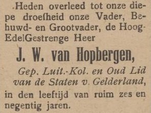
On December 11, 1913, Jacobus Wilhelmus van Hopbergen passed away at the age of 96 in his villa at Markt 18 in Aalten. He found his final resting place at the Old Cemetery on the Varsseveldsestraatweg in Aalten.
Aaltensche Courant, 17 December 1913Markt 18, Aalten
Yesterday, the Right Honorable Jacobus Wilhelmus van Hopbergen, retired Lieutenant Colonel of the Infantry in this country, born July 16, 1817, in Ravenstein, passed away here at a great age. He thus reached the age of over 96 years. We do not wish to provide a biography of this eminent man, as that would require a more refined pen than ours, but we merely wish to speak a brief word upon his passing.
After his retirement, he settled in Aalten with his family approximately 50 years ago and very quickly earned the respect of all residents; he became a full citizen of his place of residence and worked diligently toward the progress of this town.
Many who knew him in the prime of his life and learned to respect him have already departed from the earthly stage, yet a small circle remains who remember the straightforward, sincere Colonel. It was no wonder that he served for many years on the Provincial Council and the Municipal Council, and was a Churchwarden of the Reformed Congregation until he was forced to resign due to advanced age.
Devoted heart and soul to liberal principles, he was always a diligent but honest fighter. What Mr. A. Willink was to Winterswijk, Mr. Van Hopbergen was to Aalten. He was very charitable toward the poor and the sick, supported in this by his family. We shall hold his memory in honor. A good and distinguished citizen has departed from us.
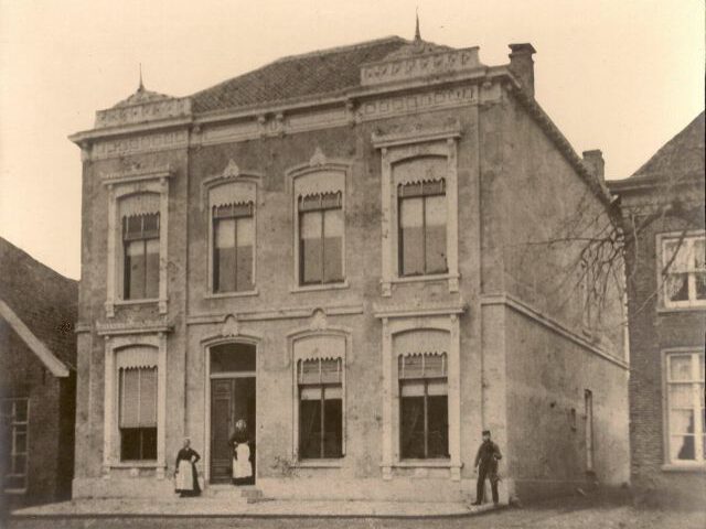
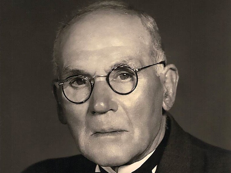
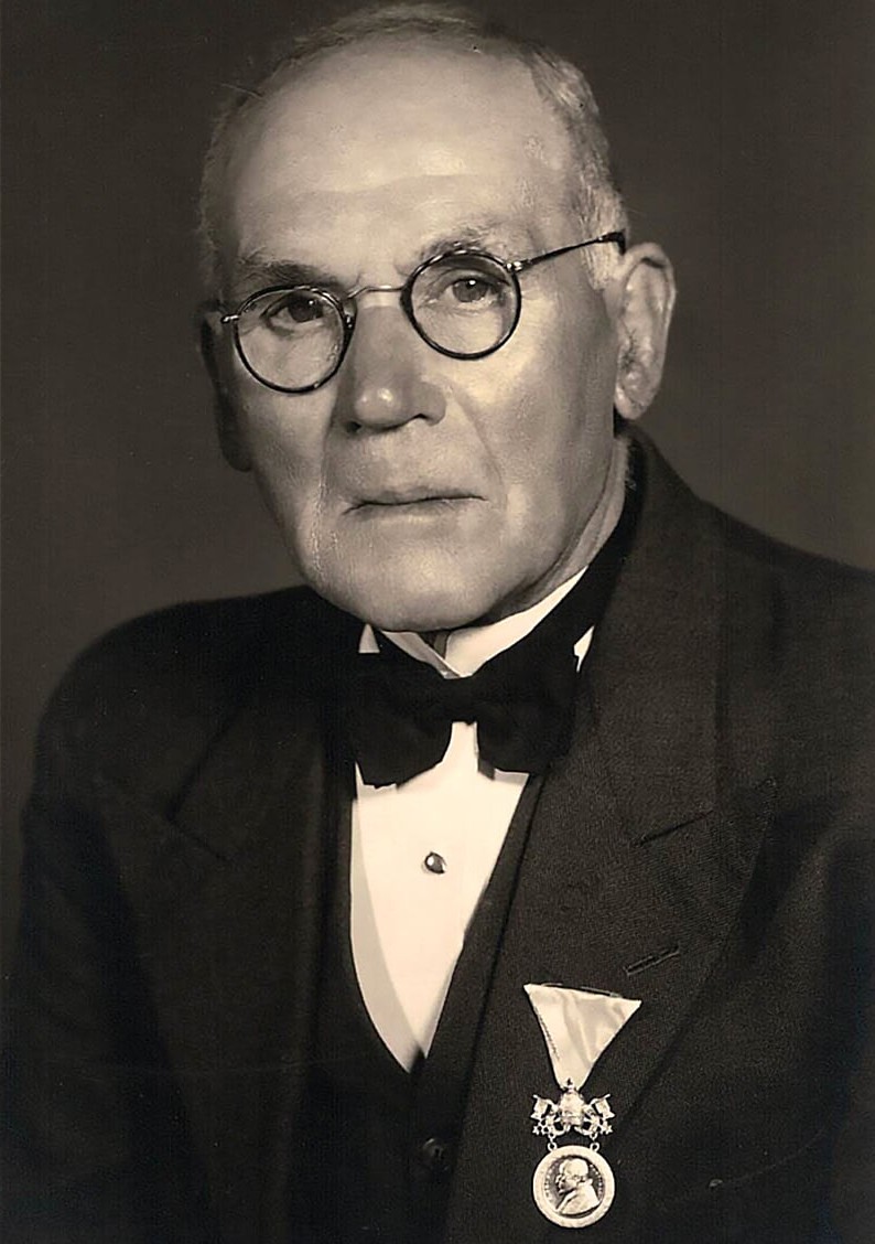
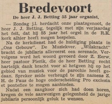
Johannes Josephus (“Jans”) Betting was born on 15 May 1871 at ‘house no. 139’ in Bredevoort, the son of Johannes Josephus Betting (a weaver) and Johanna Willemina Gördes. On 4 June 1903, he married Grada Hendrika Ubbink in Aalten. The couple went to live with her parents at ’t Zand. At that time, Jans worked as a ‘packer’ at H. van Eijck & Zoon in Bredevoort. Jans passed away on 28 January 1956 in Winterswijk.
A Life Devoted to Faith and Music
The Roman Catholic faith was a constant thread throughout Jans’ life. He was a deeply religious man: a faithful churchgoer, choir singer, and organist. He attended Mass every Sunday without ever missing a single service—even when he was ill.
From the age of fourteen, he sang in the men’s choir of the Roman Catholic church in Bredevoort. In addition, he served as the church organist for many decades. In the past, playing the organ required the use of bellows that were operated manually. This task was often performed by young boys who occasionally lost concentration… When the organ music faltered, Jans would whisper: “Keep treading, boys!”
Johannes Josephus (Jans) Betting (1871–1956) with his Papal decoration
Papal Decoration
In May 1949, Jans Betting received a Papal decoration. The Aaltensche Courant reported:
Last Sunday, our fellow townsman, Mr J. J. Betting, commemorated both his birthday and the fact that he has been permitted to play the organ in the Roman Catholic church here for 55 years.
Following the church service, a ceremony took place in „Ons Gebouw”. The „Wilskracht” wind band first performed a serenade for the jubilarian. Subsequently, the Reverend Father Pierik took the floor, expressing his heartfelt gratitude to Mr Betting for everything he has done for the parish in the field of music. The speaker said he was delighted to be able to present the high decoration Pro Ecclesia et Pontifice on behalf of His Holiness the Pope.
After a performance by a choir, the many attendees were given the opportunity to personally congratulate the jubilarian on his birthday.
Aaltensche Courant, 17 May 1949
Burglaries
After Jans’ death, the family kept the decoration in a safe. They cherished the valuable heirloom with a sense of fitting pride. Thirty or forty years later, three burglaries occurred. During one of these incidents, the safe was stolen, containing approximately ƒ1,500 and several securities. However, the family’s greatest sorrow was the loss of their grandfather’s Papal decoration.
Years later, a suspicious car was stopped during a check in the west of the country. The occupants confessed to several burglaries, including the one at the Betting residence in Bredevoort. They also admitted to having taken a safe and stated that they had thrown it into the Rhine from a bridge near Arnhem.
A diving team managed to recover the safe from the water. Although the money and papers were gone, grandfather Jans’ Papal decoration was, miraculously, still inside! The family was exceptionally overjoyed at the return of this precious treasure.
Deze website gebruikt cookies voor een optimale ervaring en analyse van bezoekgegevens. Ga je hiermee akkoord? Zonder toestemming werken sommige onderdelen van de site mogelijk minder goed.
Functioneel
Always active
De technische opslag of toegang is strikt noodzakelijk voor het legitieme doel het gebruik mogelijk te maken van een specifieke dienst waarom de abonnee of gebruiker uitdrukkelijk heeft gevraagd, of met als enig doel de uitvoering van de transmissie van een communicatie over een elektronisch communicatienetwerk.
Voorkeuren
De technische opslag of toegang is noodzakelijk voor het legitieme doel voorkeuren op te slaan die niet door de abonnee of gebruiker zijn aangevraagd.
Statistieken
De technische opslag of toegang die uitsluitend voor statistische doeleinden wordt gebruikt.De technische opslag of toegang die uitsluitend wordt gebruikt voor anonieme statistische doeleinden. Zonder dagvaarding, vrijwillige naleving door je Internet Service Provider, of aanvullende gegevens van een derde partij, kan informatie die alleen voor dit doel wordt opgeslagen of opgehaald gewoonlijk niet worden gebruikt om je te identificeren.
Marketing
De technische opslag of toegang is nodig om gebruikersprofielen op te stellen voor het verzenden van reclame, of om de gebruiker op een site of over verschillende sites te volgen voor soortgelijke marketingdoeleinden.