
Old Aalten

Category: Bredevoort Fortress

  • De Halve Maone

    De Halve Maone

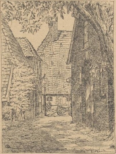
    De Halve Maone (The Half Moon) is a former ravelin and historical fortification in the small Gelderland fortified town of Bredevoort. The fortified, pentagonal island was situated on the western side of the town in the town moat, directly in front of the Aalterpoort (Aalten Gate). Together with the surrounding field of fire, ‘de Koppele’, the complex forms an important cultural-historical element, recalling the strategic significance of Bredevoort during the Eighty Years’ War and the centuries that followed.

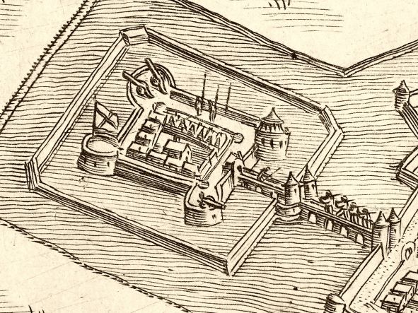
    A ravelin is an outwork of a fortification that primarily served to protect vulnerable town gates and the curtain wall behind them against enemy fire and assaults. De Halve Maone was constructed as a pentagonal island and was situated between the Ossenkop (Ox Head) and Vreesniet (Fear Not) bastions. The island was surrounded by an additional moat (the ravelin moat).

    Access to the town via the western side was divided at the time: travellers coming from the old road to Aalten crossed a first bridge over the outer moat onto the ravelin. From the ravelin, a second bridge, designed as a drawbridge, led across the town moat to the Aalterpoort. On the eastern side of Bredevoort, in front of the Misterpoort, a similar defensive work was situated at the time.

    History and Development

    The Middle Ages and the early ‘half moon’ (until 1606)

    Although it is not known when the first Aalterpoort was built, accounts from the year 1500 show that maintenance work was already being carried out on the town gates around that time. The foundation for the later ravelin was presumably laid between 1545 and 1555, when the Gelderland warlord Maarten van Rossum was appointed drossard (bailiff) of Bredevoort. Van Rossum had the medieval fortification radically modernised to render it resistant to the rise of cannon fire; he widened the moats, threw up earthen ramparts, and placed an early ‘half moon’ in front of the Aalterpoort.

    A map by the cartographer Jacob van Deventer from circa 1560 still shows the Aalterpoort as a heavy tower with an outlying roundel or barbican. On later siege maps from 1597 onwards – the year in which Maurice of Orange captured the town after a fierce siege – the gate is depicted with a drawbridge and the characteristic crescent-shaped advance fortification.

    Modernisation to the Old Dutch fortification system

    After the States forces gained control of the town and Frederick Henry of Orange successfully relieved the fortress in 1606, it was decided to thoroughly renew the medieval fortifications. The old medieval Aalterpoort was demolished in 1606. In its place, a new, brick-built gate arose that lay recessed into the main rampart. On this occasion, Van Rossum’s relatively simple ‘half moon’ made way for a larger, pentagonal ravelin.

    Decay and the Fortifications Act (19th century)

    With the introduction of the Vestingwet (Fortifications Act) in 1874, Bredevoort officially lost its military status. To save on high maintenance costs, the inhabitants of the town decided to dismantle the Aalterpoort. The wooden bridges over the moats were replaced by a permanent, earthen embankment.

    Cadastral maps from 1828 reveal that the fortifications were already in decay at that time, yet the contours of De Halve Maone and the Aalterpoort were still prominently recognisable. The maps also show the historical water management system: at the time, the Slingebeek still flowed on the eastern side of the town around the eastern ravelin. To the north and north-east of the small town, the moat around De Halve Maone was fed by the Schaersbeek, which merged into the low-lying lands and flowed on towards a weir near the former Fort Oranje. Following the dismantling, the culverted moats and the levelled ramparts on the northern side were largely put to use as allotments.

    Landscape context: ‘De Koppele’ field of fire

    Directly adjacent to De Halve Maone lies de Koppele (historically also referred to on maps as the Kleine Broek). This characteristic lowland peat area extends between the historical town centre and the current Bolwerkweg and Tolhuisweg, over which the old connecting road to Aalten used to run.

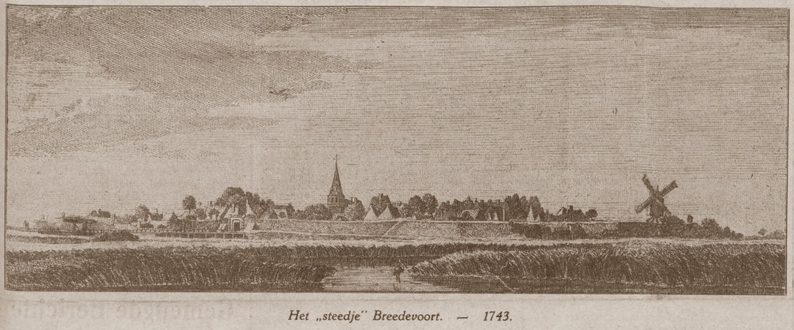
    In military terms, this open, marshy terrain functioned as the field of fire. It offered the defenders on the ramparts a clear and unobstructed view of approaching enemies. The artist Jan de Beijer captured this open landscape in 1743 in a well-known drawing from the Tolhuisweg. In the foreground of his work, a portion of the ‘voorde’ (a ford) is visible – the landscape element to which Bredevoort owes its name (‘broad ford’). Today, de Koppele is the only remaining area around Bredevoort that recalls this original, strategic setting.

    Recent Situation and Archaeology

    Culverting in the 20th century

    In the course of the 20th century, the historical structure became largely hidden from view. In 1972, the ravelin moat – which formed the course of the Schaersbeek right alongside the Tramstraat – was culverted and filled in. Further down into the de Koppele area, the brook was straightened towards the weir. The island of the former ravelin itself was transformed into an allotment complex with 40 plots, causing the historical layers to disappear from sight.

    Archaeological discoveries

    In 2022, at the instigation of the local interest group Bredevoorts Belang, an archaeological investigation took place during excavation works by grid operator Liander near the entrance to Bredevoort on the Landstraat. On this occasion, various monumental remains were encountered in the soil, including a section of brickwork that structurally belonged to the ravelin De Halve Maone.

    Future Plans and Redevelopment

    As the historical fortification structure is barely recognisable to visitors and residents in the current situation, Bredevoorts Belang presented proposals in 2025 to make this ‘veiled heritage’ more visible and accessible.

    One of the proposals is the removal of the current dam and the culvert that separate the so-called Kleine Gracht and Grote Gracht (Small Moat and Large Moat). By replacing this barrier with a new bridge in the Landstraat, the moats will once again be brought into open connection with each other.

    Regarding the status and progress of these plans, nothing is currently known to us (as of June 2026).

    Sources


  • Lordship of Bredevoort

    Lordship of Bredevoort

    This page is still ‘under construction’…

    County of Lohn

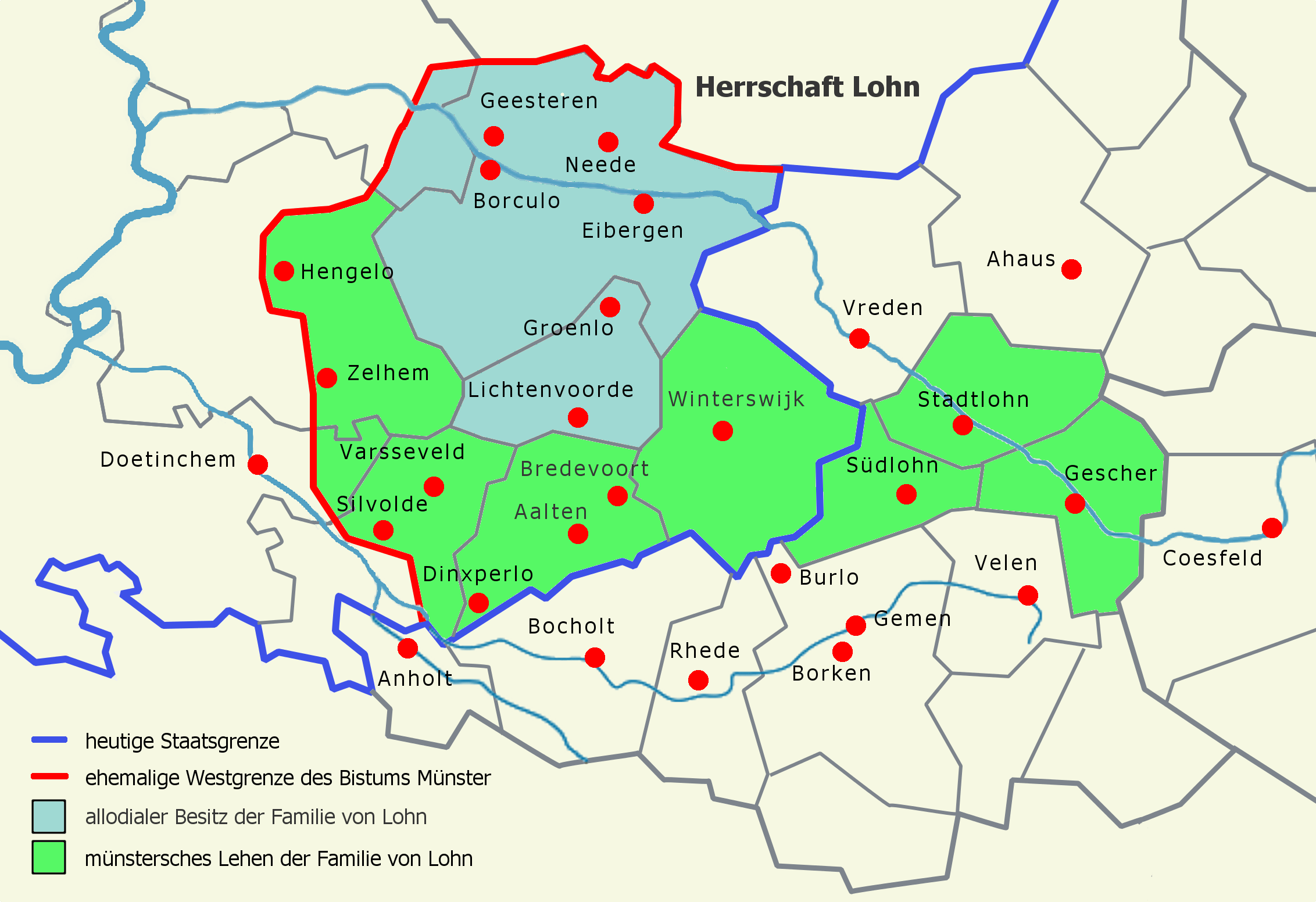
    De voormalige heerlijkheid Bredevoort maakte oorspronkelijk deel uit van het graafschap Lohn, dat vermoedelijk in de 11e eeuw is ontstaan. Dit graafschap omvatte in 1152 de kerspelen Lohn, Winterswijk, Aalten, Varsseveld, Zelhem en Hengelo (G). In hun streven naar onafhankelijkheid kwamen de graven van Lohn in conflict met de bisschop van Münster, wiens leenheerschappij zij in 1152 tenslotte moesten erkennen. De burcht Bredevoort was in 1246 voor de helft eigendom van graaf Herman van Lohn, die in dat jaar zijn deel in leen opdroeg aan graaf Otto van Gelre.

    Upon the death of the last Count of Lohn in 1316, his territory disintegrated. The parishes of Varsseveld and Silvolde went to the Lord of Wisch; the parishes of Zelhem and Hengelo had already been sold to Guelders. In 1316, the Bishop of Münster purchased half of Bredevoort Castle, along with its share of Lohnish rights, from Otto van Ahaus, one of the heirs. The other half of the castle had already been in episcopal possession since 1284.

    County of Guelders

    This purchase led to a dispute between Münster and Guelders, resulting in a war in 1324. Count Reinald of Guelders invaded the Bishopric of Münster and was defeated at Coesfeld, though he had already conquered Bredevoort. At the peace treaty concluded in Wesel in 1326, Reinald retained Bredevoort and received the jurisdictions of the surrounding parishes of Aalten, Dinxperlo, and Winterswijk as a pledge. The Bishop of Münster was entitled to redeem this pledge at any time for 3,500 gold marks, which, however, never occurred. From 1326 onwards, the area became an independent territory administered by a ducal official.

    Gemen and Steinfurt Pledge (1388-1526)

    In 1388, William of Jülich, as Duke of Guelders, pledged his castle, town, and the District of Bredevoort with its three parishes to Lord Henry III of Gemen in exchange for a substantial loan. Successive generations of this family remained pledge-holders of the lordship until 1492, when the pledge passed to his heirs and subsequently to the Counts of Bentheim-Steinfurt. It was not until 1526 that Duke Charles of Guelders redeemed the pledge and took the lordship back under his own administration. In 1534, he entrusted Bredevoort to his commander Marten van Rossum, who received the lordship as a pledge in 1545 from Emperor Charles V, the legal successor to the Dukes of Guelders.

    Anholt Pledge (1562-1612)

    When Van Rossum died in 1555, the pledge passed via Johan van Isendoorn to Hendrik van Isendoorn à Blois, who received the pledge sum back in 1562. King Philip II of Spain, acting as Duke of Guelders, then pledged the lordship for 50,000 Flemish shields to his vassal Dietrich van Bronckhorst-Batenburg. He was the Lord of neighboring Anholt in Westphalia, who already possessed many properties and rights within the Lordship of Bredevoort.

    After the Reformation, the Lords of Anholt remained Roman Catholic and aligned with the Spanish side. Consequently, Bredevoort was besieged and conquered by Prince Maurice of Nassau in 1597. Lady Gertrud von Milendonck, the widow of Jacob van Bronckhorst-Batenburg, had the lordship returned to her by the Republic in 1602. However, the pledge was redeemed by the States of Gelderland in 1612 and subsequently taken over by Prince Maurice.

    Many archival documents concerning the period 1526-1612 are located in the Bredevoort Collection within the Fürstlich Salm-Salmsches Archiv at the Wasserburg Anholt near Isselburg (D). Older documents from before 1562 were likely transferred to their house archive at the time by order of the Anholt pledge-holders as evidence of their rights. After the termination of the

    Pledge City of the House of Orange

    In 1697, Bredevoort was granted as a free lordship to King-Stadtholder William III, whose heirs possessed it until 1795.

    Van het Rijksarchief in Friesland werd in 1986 uit de collectie van het Fries Genootschap het reglement voor de poortwachters te Bredevoort van 1726 ontvangen.

    In het huisarchief van de voormalige herberg De Leste Stuver te Bredevoort, berustend te Aalten, bevindt zich o.a. een almanak, gebruikt door de Stadhouder of de Landschrijver als zakagenda in de periode 1737/38.

    In 1646 werd het kasteel te Bredevoort verwoest tengevolge van blikseminslag in de kruittoren. Het duurde ruim 50 jaar, eer nieuwe huisvesting werd gerealiseerd. In 1699 verrees aan de Landstraat te Bredevoort een nieuwe kanselarij, het Ambthuis.

    District of Bredevoort (1795-1811)

    After the Batavian Revolution in 1795, the possessions of the House of Orange were declared forfeit; the Lordship of Bredevoort was placed under civil administration. In 1798, the lordships were officially abolished. The former municipalities of Aalten, Bredevoort, Dinxperlo, and Winterswijk were established in 1795 and abolished in 1798. Following the abolition of the lordships in 1798, the former municipality of Lichtenvoorde was added to the District of Bredevoort and separated from it again in 1802.

    In 1994, Dr. G.J.H. Krosenbrink of Winterswijk donated a report concerning the administrative organization of the old District, prepared for the new District administration in the period 1798-1802, originating from the then-district board member H. Willink Azn. of Winterswijk.

    Het Ambt Bredevoort bleef als bestuurlijke eenheid in stand tot de Franse overheersing. In de jaren 1811 en 1812 werd het opgedeeld in de Mairieën Aalten, Bredevoort, Dinxperlo en Winterswijk.

    Het archief van het Ambt werd bewaard op de kanselarij, het Ambthuis te Bredevoort. In 1795 werd het op last van het Provisioneel Bewind in beslag genomen en geïnventariseerd, waarna het onder het beheer werd gesteld van de secretaris van de Municipaliteit van Aalten. Na de Franse overheersing werden bij het herstel van het Nederlands bestuur bescheiden uit het archief gelicht en overgedragen aan de nieuwe gemeenten Aalten, Dinxperlo en Winterswijk. Ook de voormalige rentmeester J.B. Roelvink van de Nassause Domeinen behield het kanselarij-archief onder zich, dat in 1985 helaas door een rechtsopvolger werd vernietigd.

    Administration

    Bredevoort was originally a small ‘borgman’ town based on the Westphalian model. The noble defenders of the castle lived in fortified houses on the outer bailey, which consequently took on the character of a fortress. In the neighboring Bishopric of Münster, such ‘borgmannen’ exercised authority and jurisdiction over their staff and the serf inhabitants of the castle complexes they managed in Horstmar and Nienborg.

    Upon the transfer of Bredevoort in 1326, the Bishop of Münster released his Bredevoort ‘borgmannen’ from their oath so they could enter Guelders’ service. In 1503, the Bredevoort ‘borgmannen’ obtained similar privileges from the then-pledge-holder, Everwijn van Steinfurt. However, no city rights for Bredevoort have survived. The military and administrative role of the ‘borgmannen’ ended after the defense was entrusted to a garrison during the 16th century.

    The daily administration of the Lordship of Bredevoort rested with the Drost (Bailiff). Following the Münster occupation during the war years 1672-1674, a separate urban administration of a stadtholder and regents of the city of Bredevoort existed briefly within the walls. The Drost often also served as the Richter (Judge). Jurisdiction was provided by the Richter with two ‘keurnoten’ (assessors). The court was held once every two weeks in Aalten, Bredevoort, and Winterswijk. Court days for Dinxperlo were held in Aalten.

    Jurisdiction in the city of Bredevoort was exercised by the Richter of the lordship with two ‘keurnoten’, as in the other parishes. Other officials at the court were the Land Scribe (secretary) and the Advocate-Fiscal (public prosecutor). The Land Scribe also served as the secretary to the Drost. Since the latter usually did not reside in the lordship, the Land Scribe often also acted as his deputy as acting-Drost or Stadtholder. Bredevoort had a fortress commander, the “Commandeur der Forteresse”. This position was often combined with that of acting-Drost in a single person. Furthermore, there was a whole series of lower officials, including a gauger, a tool sharpener, a surveyor, and armenjagers (rural constables).

    Due to the fact that members of the noble Van Pallandt family and the related families of Van Lintelo and Van Coeverden held the position of Drost of Bredevoort for a long time, a large number of documents concerning Bredevoort matters from the period 1638-1796 are also found in the archive of House Keppel, likewise held at the Gelders Archief in Arnhem.

    The last Drost of the District of Bredevoort, since the Batavian Revolution in 1795, was the Winterswijk citizen W. Paschen Gzn. of Winterswijk. His accounts for the period August 1808 – March 1811 were audited and deposited in Winterswijk on September 4, 1812, by the joint mayors of Aalten, Bredevoort, Dinxperlo, and Winterswijk. As early as 1811, Paschen, as temporary mayor of Winterswijk, requested the former Land Scribe to transfer documents concerning Winterswijk matters. According to a letter in the archive of the Municipality of Winterswijk, a chest of archival records was transported by wheelbarrow from Aalten to Winterswijk in 1813. The selection process at the time was somewhat arbitrary, so other Bredevoort documents also ended up in Winterswijk. Steward J.B. Roelvink also transferred Bredevoort documents to the Mayor of Winterswijk in 1815. Incidentally, Lichtenvoorde was only part of the District during the years 1798-1802.

    Since 1612, officials were appointed by the Nassau Domain Council. For appointment data, see the so-called ‘Ambtboek’, held in the archive of the aforementioned Domain Council at the National Archives in The Hague. Information on appointments in the District of Bredevoort can also be found in the archive of the Drost and Geërfden, inv. nos. 22-33, and in the archival collection Local Government Winterswijk, inv. no. 14. Through the Drosten, many personnel records also ended up in the Keppel house archive, held at the Gelders Archief in Arnhem.

    Besides the city of Bredevoort, the lordship consisted of three judicial districts, which coincided with the three parishes of Aalten, Dinxperlo, and Winterswijk. In each parish, a ‘voogd’ (warden) and one or two ‘ondervoogden’ (sub-wardens) were appointed, acting as intermediaries between the inhabitants of the parishes and the administration in Bredevoort. Each parish consisted of a village and a number of rural districts, called guilds, which were divided into wards. These were headed by ward and guild masters, who were responsible for the further dissemination of messages and the execution of orders. Additionally, each rural district had a messenger, an office tied to a specific farm.

    Financial matters were handled per parish by the local ‘geërfden’ (landed stakeholders). These representatives of the population were delegated per village and rural district and were accountable to the Drost. The town of Bredevoort had its own Steward, who acted on behalf of the local ‘geërfden’. Each parish had its own collector of the ‘verponding’ (land tax). In Bredevoort, the ward masters sometimes acted collectively as collectors of the ‘verponding’. The churchwardens in each parish, responsible for managing the capital and property of the local church, were elected from the ‘geërfden’ and had to provide accounts to the Drost and their fellow ‘geërfden’. Alongside the ‘diaconie’ as a church institution, there was also a secular institution for poor relief, the ‘provisorie’. Like the churchwardens, ‘provisoren’ were elected from the ‘geërfden’ and were required to account for their management in the same manner.

    Sources


  • The Misterpoort City Gate

    The Misterpoort City Gate

    Bredevoort

    De Misterpoort is een voormalige stadspoort in Bredevoort. De poort maakte deel uit van de vestingwerken van Bredevoort. Tegenwoordig herinnert een café-restaurant met deze naam nog aan de oude stadspoort, die haar naam weer dankt aan de weg naar buurtschap Miste. In een poortwachtersreglement uit 1726 werd de poort Munsterspoort genoemd.

    Following the Siege of Bredevoort in 1606, work began in late March on the construction of fortifications designed by the urban planner Adriaen Anthonisz van Alcmaer. During this process, the medieval city walls and their gates disappeared. The town was equipped with bastions and ravelins, and the Misterpoort was replaced by a brick structure set within the rampart. The name ‘Misterpoort’, however, remained.

    In 1704 werden er nog verbeteringen aangebracht aan zowel de Misterpoort, als aan de tegenoverliggende Aalterpoort volgens de nieuwste inzichten van die tijd van Menno van Coehoorn.

    In 1727, two new counterscarps were constructed in front of both city gates, a project that took two years to complete. In 1755, the fortifications were decommissioned by the Council of State and transferred to the civil authorities. Some time later, in 1784, a government inspection of the fortifications revealed that citizens had excavated more than half of the ramparts down to ground level—with the exception of two bastions—and had demolished the gates and bridges. Plans were drawn up to restore the fortifications and add three lunettes, but these were never carried out.

    Archeology

    Excavations took place at the site in 1963 and 1979. In 1963, the State Service for Archaeological Heritage (ROB) was present and reported: “The foundation remnants were found to have been constructed using brick blind arches over the fill of a moat. On the inner side (the town side) of the moat, the remains of exceptionally heavy, vertically buried oak posts were found within the embankments.”

    During the 1979 excavations, a wall with a thickness of 1.70 metres, featuring transverse foundations, was discovered and quickly demolished. However, the remains were measured and photographed by the newly established local ADW Archaeological Working Group. These findings have raised more questions than answers, and it remains difficult to conclude which remnants date from which specific period.

    Waarschijnlijk is het enige zichtbare overblijfsel van de stadspoort bewaard gebleven in de hal van de Sint-Georgiuskerk. Het betreft hier een gevelsteen met een afbeelding van het schutspatroon van Bredevoort, St. Joris en de draak.

    Features


    FunctionCity gate
    Year of constructionunknown
    Demolitionunknown

    Sources


  • The Aalterpoort City Gate

    The Aalterpoort City Gate

    Bredevoort

    The Aalterpoort was one of the two city gates of Bredevoort and formed part of the fortifications of Bredevoort. The gate was situated on the western side of the fortified town and marks the start of the Landstraat.

    It is unknown when the first gate was constructed at this site. Accounts from the year 1500 show that maintenance work was carried out on the gates that year. A map by Jacob van Deventer from 1560 depicts a heavy tower with a bulwark or barbacane in front of it. On siege maps (from 1597 onwards), the city gate is shown with a drawbridge. The gate is flanked by two towers topped with spires. A “half-moon” (halve maan) outwork is situated in front of this gate.

    Improvements ca. 1550

    It is known that Maarten van Rossum ordered improvements between 1545 and 1555. It is possible that the gatehouse was also renovated during this period. This medieval gate was demolished in 1606, shortly after the relief of the town by Frederick Henry. From that time onwards, Bredevoort was equipped with fortifications according to the latest insights of the era, which included a new gate. This was a brick-built gate set within the rampart. The half-moon was replaced by a larger ravelin.

    Demolition

    Following the introduction of the Fortifications Act (Vestingwet) in 1874, the gate was demolished by residents to save on maintenance costs. The bridge was replaced by a causeway.

    Today, two residential buildings stand at this location, completed in 1998 on the site of the former city gate. A remnant of the original city gate was incorporated into the design.

    Features


    FunctionCity gate
    Year of constructionunknown
    Demolition19th century

    Sources


    • ‘Breevoort can ick vergeten niet’ (blz. 126), H.A. Hauer
    • ‘Bredevoort een Heerlijkheid’, Staring Instituut
    • Wikipedia
  • Bastion Stoltenborg

    Bastion Stoltenborg

    Bredevoort

    Bastion Stoltenborg was one of the six bastions of Bredevoort. It was situated to the east of the town, at what is now the start of Pater Jan de Vriesstraat, and formed part of the Bredevoort fortifications.

    Behind the houses on the Ambthuiswal lay the eight-metre-high hollow bastion, equipped with three cavaliers (katten) in each corner. The terreplein was accessible from Hozenstraat and Ambthuiswal. The gorge (keel), or entrance to the bastion, was located just past the junction with Gasthuisstraat, directly in front of the town farm situated next to the Ambtshof.

    The name Stoltenborg is thought to be related to the German word ‘stolz’ (proud), perhaps referring to the proud ‘borg’ (stronghold) of Bredevoort.

    Reconstruction

    The image shows a reconstruction of Bastion Stoltenborg. It illustrates the bastion’s position relative to the houses that stand there today; the adjacent building is the town farm next to the Ambtshof, with Gasthuisstraat running in front of it. The reconstruction also shows the onderwal (lower rampart) situated in front of the bastion. The moat has since been filled in; the site is now occupied by ‘t Bastion school and the surrounding modern housing.

    Features


    FunctionBastion
    Year of constructionunknown
    Demolitionunknown

    Sources


  • Bastion Ossenkop

    Bastion Ossenkop

    Bredevoort

    Bastion Ossenkop (‘Ox Head’) was one of the six bastions of Bredevoort. It was situated to the south-west of the town, at what is now the start of Kerkstraat coming from Koppelstraat, and formed part of the Bredevoort fortifications.

    On the site behind St George’s Church lay the eight-metre-high ‘solid’ bastion, equipped with three cavaliers (katten) in each corner. The terreplein was accessible via ramps (oprillen), possibly from Koppelstraat and Kerkstraat.

    Reconstruction

    The image shows a reconstruction of Bastion Ossenkop. It illustrates its position relative to the houses that stand there today; St George’s Church now stands upon the curtain wall (courtine). The gorge (keel) of the bastion is now occupied by gardens, and the site of the bastion itself is currently the Ossenkop playground.

    The reconstruction also shows the lower rampart situated in front of the bastion. The moat has been filled in; this area is now the site of the school and the surrounding modern housing on Schoolstraat and Tramstraat. Nothing has been preserved to serve as a physical reminder of the former bastion.

    Features


    FunctionBastion
    Year of constructionunknown
    Demolitionunknown

    Sources


  • Bastion Vreesniet

    Bastion Vreesniet

    Bredevoort

    Bastion Vreesniet (‘Fear not’) was one of the six bastions of Bredevoort. It was situated to the west of the town, in the area now behind Prinsenstraat, and formed part of the Bredevoort fortifications. Its remains are protected as a national monument (rijksmonument).

    At this location, the outline of the bastion is still vaguely visible on the modern map of Bredevoort. It was once an eight-metre-high ‘hollow’ bastion, equipped with three cavaliers (katten) in each corner. The gorge (keel), or entrance to the bastion, was situated just past the junction of Landstraat and Kerkstraat; the alley behind these houses still exists today. The present-day town meadow once served as the bastion’s terreplein (the level space behind the ramparts).

    In 1782, the bulwark was granted under a long-term lease (erfpacht) to Bernard Andries Roelvink. During the 19th century, the fortifications were dismantled to make way for the gardens that are still there today. A small section of the onderwal (lower rampart) has been preserved, upon which the Roelvink family’s tea pavilion was built.

    Reconstruction

    The image shows a reconstruction of Bastion Vreesniet. It illustrates the bastion’s position relative to the houses that stand there today, with Sint Bernardus visible on the right. The lower rampart in front of the bastion is also shown. The terreplein is now the small meadow situated between the gardens and Kerkstraat.

    The moat in front of it is known today as the Grote Gracht (Large Moat). The section of the moat to the left of the ravelin is now known as the Kleine Gracht (Small Moat). The filled-in section of the moat and the glacis (sloping bank) that were once here are now occupied by the ‘De Halve Maan’ (Half Moon) allotments.

    Features


    FunctionBastion
    Year of constructionunknown
    Demolitionunknown

    Sources


  • Bastion Treurniet (Kruittoren)

    Bastion Treurniet (Kruittoren)

    Bredevoort

    Bastion Treurniet (‘Grieve Not’), or Kruittoren (Powder Tower) in common parlance, is a national monument (rijksmonument) and was one of the six bastions of Bredevoort. It is situated to the north of the town, on what is now the Kruittorenstraat opposite the community centre Ons Huis, and formed part of the Bredevoort fortifications.

    At this location, a rise in the landscape can still be seen today; this was the onderwal (lower rampart) of the bastion. Behind it lay an eight-metre-high hollow bastion, equipped with three cavaliers (katten) in each corner. A powder magazine (kruithuis) for the garrison stood upon the terreplein. The gorge (keel), or entrance to the bastion, was situated just past the junction of Kruittorenstraat and ’t Zand.

    The powder tower of Bredevoort Castle must also have stood at this site. The curtain wall (courtine) of the main rampart ran behind the houses towards Sint Bernardus. In 2010, an artwork was placed on the remnants of the lower rampart in the form of steel ribs that represent its original profile.

    Reconstruction

    The image shows a reconstruction of Bastion Treurniet. It illustrates the bastion’s position relative to the houses that stand there today. The lower rampart situated in front of the bastion is also visible. The section on the right is the part that remains today as a shapeless mound.

    The terreplein is now the small meadow on Kruittorenstraat. The powder magazine would once have stood on the spot now occupied by the Bredevoort Schittert building. The section of the moat shown in the reconstruction still exists today.

    Features


    FunctionBastion
    Year of constructionunknown
    Demolitionunknown

    Sources


  • Bastion Welgemoed

    Bastion Welgemoed

    Bredevoort

    Bastion Welgemoed is een voormalig bastion, zuidelijk gelegen tegen het stadje Bredevoort. Het was onderdeel van de Vestingwerken van Bredevoort. Doordat molen De Prins van Oranje op dit bastion werd gebouwd bleef deze gespaard van ontmanteling en is dit dan ook Bredevoorts enige overgebleven bastion.

    The bastion is no longer easily recognisable. It was once eight metres high and equipped with three cavaliers (katten) plus a breastwork. Due to the excavation of the breastwork, the bastion now stands six metres high. The lower rampart has also been removed, and the surrounding moats have been filled in.

    Reconstruction

    Op de afbeelding een weergave van een reconstructie van het bastion Welgemoed. Zichtbaar gemaakt is de ligging ten opzichte van de huizen die er tegenwoordig staan. Ook zichtbaar de onderwal die voor het bastion ligt. Het deel aan de rechterkant is tevens het deel dat er tegenwoordig vormloos ligt. De courtine aan de linkerkant op de afbeelding is grotendeels verdwenen, alleen een verhoging ter hoogte van de Sint Georgiuskerk is een laatste restant van de hoofdwal die hier naar Bastion Ossenkop liep.

    Features


    FunctionBastion
    Year of constructionunknown

    Sources


  • Bastion Onversaegt (Izerman)

    Bastion Onversaegt (Izerman)

    Bredevoort

    Bastion Onversaegt (‘Undaunted’), popularly known as Izerman, was one of the six bastions of Bredevoort. It was situated to the north-east of the town, near the site of ’t Kleuterbastion school on Izermanstraat, and formed part of the Bredevoort fortifications. The bastion was excavated and levelled during the 1930s.

    On the grounds of ’t Kleuterbastion (nursery school) and the adjacent football pitch lay the eight-metre-high ‘solid’ bastion, equipped with three cavaliers (katten) in each corner. The terreplein was accessible via ramps (oprillen) from Hozenstraat, and possibly via ’t Zand.

    Reconstruction

    The image shows a reconstruction of Bastion Onversaegt. It illustrates the bastion’s position relative to the houses that stand there today, with the Breede Huus on the left and a corner of the Meestershuus on the right. Some maps suggest that this bastion was equipped with a water reservoir. This is not certain, however, as many houses in Bredevoort possessed their own wells.

    The tip of this bastion was located approximately on the centre circle of the football pitch. The flanking streets next to the Kleuterbastion run parallel to the original shape of the bastion. The position of the curtain wall (courtine) between the school and the Breede Huus is still clearly visible today by the line of the hedge. This curtain wall connected the bastion with the adjacent Bastion Treurniet. The outlines of the filled-in moat are still clearly visible on aerial photographs, and remnants of this singel (moat/canal) still exist today.

    Features


    FunctionBastion
    Year of constructionunknown
    Demolition1930

    Sources


  • The Merfelt Cellar

    The Merfelt Cellar

    Prinsenstraat 3a, Bredevoort

    The late-medieval Merfelt Cellar belonged to a borgmanhuis (townhouse of a knight) where Adolf van Merfelt, a borgman of Bredevoort, resided in former times. The cellar of this townhouse is both rare and ancient. The method by which it was vaulted is highly unusual for a private dwelling: it features four cross vaults with a central supporting pillar.

    In 2014, the Merfelt Cellar was nominated for the Aalten Municipality Heritage Prize. The reason for the nomination was the meticulous care and respect for historical character and the use of authentic materials during its restoration.

    The restoration work on the cellar took place over several years. The highlight of the project was the repair of the vaulting, which ensured the long-term stability of the cross vaults.


    Owners

    This overview is incomplete.

    YearPlotOwnerDescription

    Residents

    Address directory 1967

    Prinsenstraat 3a

    B. te Winkel

    Features


    FunctionCellar
    Year of constructionLate Middle Ages
    ListedGemeentelijk
    monument
  • Ambthuis (Administrative House)

    Ambthuis (Administrative House)

    Landstraat 17, Bredevoort

    According to its wall anchors, the original Ambthuis (Administrative House) dated from 1699. For a century, it served as the centre of power for the Heerlijkheid (Lordship) of Bredevoort. The Ambthuis was also known as the Mauritshuis, as Prince Maurice had clearly left an unforgettable impression on the local inhabitants.

    Chief Court

    Following the gunpowder tower disaster of 1646, the town and lordship of Bredevoort had been left without an ambthuis (a building combining a courthouse and a town hall). It would take over fifty years before a new one was constructed. The building was likely connected to the Misterpoort, the city gate situated opposite the house.
    The building also served as the hoofdgerecht (chief court) of the lordship. While courts existed in Aalten and Winterswijk as well, serious offences were always tried in Bredevoort, with the drost (bailiff) presiding as judge.

    The cellars contained several dungeons (cachots), cells, and a torture chamber equipped with the necessary implements. Those sentenced to death were held in a cell devoid of daylight and fresh air. If a suspect refused to confess, the threat of the torture chamber was often enough to secure a plea of guilt. Sentences were traditionally pronounced on ’t Zand. In the case of a death sentence, the condemned was immediately taken to the Galgenbulte (Gallows Hill) on the Hollenberg for execution. Usually, this meant hanging from the gallows that had stood there for centuries, waiting for its victims. It is said that the gallows could be seen from the Aalterpoort. For the local population, such executions were a sensation, and people from all over Bredevoort and Aalten would turn out to witness the event.

    Other Functions

    After the French period, the building lost its original function and was used for various purposes, including as a shop for the Catholic cooperative. This cooperative was founded by the workers’ association in 1920. In the past, Catholics would frequent this shop, while those of other faiths would go to the other cooperative further down Landstraat.

    The Ambthuis was demolished around 1963. The cellars of the Ambthuis, which included two prison cells, were still located beneath the shop. In 1964, the foundation stone was laid for the construction of the Betting furniture store on this site. This building was in turn demolished in 2009, after Betting moved to new premises on Prins Mauritsstraat.

    New Construction

    Today, the site of the old Ambthuis is occupied by a care apartment complex consisting of twenty apartments and a restaurant. The new building was again given the name ‘Ambthuis’. In terms of its exterior, the new building bears many similarities to its illustrious predecessor. A replica of the historic sundial was attached to the building, and a replica of the bandstand was placed in front of it. An original gable stone from the old Ambthuis was built into the front facade, bearing the inscription: “Die kan lide haet en nijt, die overwint in korten tijd” (He who can endure hate and envy, shall overcome in a short time).


    Owners

    This overview is incomplete.

    YearPlotOwnerDescription
    1832B-104Jan Barend Top, bleacher390 m² house & yard

    Residents

    Population register 1823-1838

    Bredevoort 16

    Johannes Bernadus Top (Weseke/D, 28-07-1749)
    Hermina Legeschaar (Kruiskapel/D, 28-11-1789)

    Population register 1838-1850

    Bredevoort 8

    Johannes Bernadus Top (Weseke/D, 28-07-1749)
    Hermina Legeschaar (Kruiskapel/D, 28-11-1789)

    Population register 1850-1870

    There’s still a gap in our information here…

    Population register 1870-1880

    Bredevoort 10

    Jean Leander van Eijck (Sint-Niklaas/B, 25-11-1808 – Bredevoort, 25-02-1888)

    Population register 1880-1890

    Bredevoort 17

    Jean Leander van Eijck (Sint-Niklaas/B, 25-11-1808 – Bredevoort, 25-02-1888)

    Next (head) resident, daughter:

    Johanna Christina Theodora van Eijck (Bredevoort, 18-06-1848)

    Population register 1890-1900

    Bredevoort 11

    Johanna Christina Theodora van Eijck (Bredevoort, 18-06-1848)

    Population register 1900-1910

    Bredevoort 9 > 9

    Johanna Christina Theodora van Eijck (Bredevoort, 18-06-1848)

    Population register 1910-1920

    Bredevoort 9

    Johanna Christina Theodora van Eijck (Bredevoort, 18-06-1848)

    Next residents (1918-1922):

    Bredevoort 9 > 225

    Carl Rotthoff (Castrop/D, 24-12-1872), engineer
    Antonia Johanna Josepha Maria Sevink (Bredevoort, 05-07-1879)

    Address directory 1934

    Bredevoort 225 > Landstraat 17

    Co-op Shop “Eigen Hulp”

    Address directory 1967

    Landstraat 17

    W.H. Betting
    Mej. J.W. Betting

    Features


    Cadastral no.B-1824
    FunctionGovernment building,
    Residential house,
    Shop
    Year of construction1699
    Demolitionca. 1963
    Year of
    current building
    2010
  • Bredevoort, Pledged City of the House of Orange

    Bredevoort, Pledged City of the House of Orange

    De Graafschapper, 7 June 1948

    During his visit to East Gelderland next week, Prince Bernhard will also visit the old fortress of Bredevoort. Bredevoort has been a pledged city of the House of Orange since Frederick Henry conquered it for the States, and the current members of the House of Orange still hold the title of Lord of Bredevoort. In connection with this, we recently visited Bredevoort, where we had an interview with one of the local historians, who shared interesting details about the past of this ancient town.

    Little is known about the earliest history of Bredevoort. It was traditionally a possession of the Lords of Anholt. It is likely that a church was established around the 14th century near the castle, which probably dated back to much earlier times. The region was impoverished, which was hardly surprising, as bands of wandering soldiers regularly moved back and forth robbing and plundering, with the defenseless rural inhabitants suffering the most. During the Eighty Years’ War, before the Twelve Years’ Truce, it even occurred that the residents of Winterswijk had to seek safety within the walls of Bredevoort.

    The conquest by Prince Maurice

    In 1598, Prince Maurice laid siege to Bredevoort and captured it after a siege; however, Bredevoort paid a heavy price for its newly acquired freedom, as the entire town burned down, with the exception of the Castle, which stood on the site where the Dutch Reformed school is now located. To replace the Church, which also burned down completely at that time, the Church that still stands in Bredevoort today was built. A unique feature of this Church is that the tower, unlike those of other churches, was not built next to the Church but on top of it, resting entirely on an oak base. During the upcoming church restoration, this will be replaced with concrete. The historical value of this Church is also evident from the fact that it is listed as a national monument, meaning this institution will also contribute to the restoration costs.

    Frederick Henry also conquers Bredevoort

    Around 1600, Bredevoort changed hands again as the Spaniards retook possession of the fortress. To them, Bredevoort was nothing more than a den of thieves from which they terrorized the region. This situation lasted until 1627, when the States commissioned Frederick Henry to reconquer Bredevoort. He performed his task in such a manner that the States, in appreciation of his services, granted him the Seigniory of Bredevoort as private property. From that time on, the House of Orange has always held the title of Lord of Bredevoort.

    This also explains why East Gelderland, specifically Winterswijk, Aalten, and Dinxperlo, extends so far into Germany. This entire area belonged to the Seigniory of Bredevoort and thus came into the possession of the House of Orange, and consequently the Netherlands, with the conquest of Bredevoort.

    One might wonder why Frederick Henry did not also conquer Anholt, which was also connected to Bredevoort, but the explanation lies in the fact that the Lords of Anholt were related to the House of Orange, and he likely spared them for that reason.

    Seigniorial rights

    Through the possession of Bredevoort, the House of Orange acquired Seigniorial Rights here, such as the milling right. This meant that within the Seigniory of Bredevoort, milling was only permitted at the mill in Bredevoort, the watermill at De Pol in Aalten, and the watermill near Den Helder in Winterswijk. Regarding the milling right, it is known that in 1868, an official lease agreement signed by Frederick himself was still in the possession of the Heusinkveld family in Bredevoort, granting them the right to lease the mill in Bredevoort from generation to generation. It is a pity that this lease agreement has been lost.

    Naturally, other members of the House of Orange were also Lords of Bredevoort. Well-known stewards came from the Roelvink family, which is still known today, and some of its members later served as Mayor of Aalten.

    William V in Bredevoort

    It is known that Stadtholder William V also once visited Bredevoort. The minutes of the Dutch Reformed Church mention that he donated several Golden Riders for the poor of Bredevoort.

    The French Period

    During the French period, everything belonging to the Seigniory was sold. Large-scale landownership, as it is still known today around Winterswijk, dates from that time. Entire areas were then sold for sometimes only a few guilders. Some of the new owners found themselves in difficulty with their newly acquired property because they were unable to cultivate everything, so they planted forests instead; thus, large areas of forest near Winterswijk date from that time, which is consistent with the fact that most of the Winterswijk forest is approximately 150 years old. After the French period, the House of Orange never regained these lands, so they have only held the title since then.

    The House of Orange does not appear to have made any official visits to Bredevoort since that time, likely because Bredevoort is relatively poor in historical buildings and institutions. However, that the ties were never completely severed was evident in 1900 when H.M. Queen Wilhelmina made ƒ 100 available for the restoration of the Church in Bredevoort.

    H.R.H. Prince Bernhard in East Gelderland

    Yesterday, the final day of H.R.H. Prince Bernhard’s visit to East Gelderland flew by once again as the Prince’s open Cadillac traveled under the radiant summer sun through one of the most scenic parts of our country, past ripening grain, busy farmers, cheering and singing schoolchildren, and an enthusiastic population; once again, the Wilhelmus sounded many times, and the Prince raised his hand in greeting countless times with a charming smile on his tanned face; once again, it became a true triumphal procession.

    On this third day, H.R.H. departed from Ruurlo, arriving in Zieuwent around a quarter to nine at the farmhouse of farmer Weelink, which dates from 1737. After the Prince had briefly toured the farm, he proceeded at pace to Harreveld, where a group of young people waited in suspense at the Roman Catholic Reformatory; surrounded by hundreds of pupils from the Reformatory, H.R.H. was received and addressed by the chairman of the Reformatory board.

    Lichtenvoorde prepared a grand welcome for H.R.H.; many thousands, again adorned with the national colors, saw the procession arrive in the thousand-year-old town, preceded by ten motorcyclists from the local Motor Club. The Prince stepped out in front of the Roman Catholic rectory. Inside the rectory, the Prince listened for about fifteen minutes to the Pastor-Dean of Groenlo, who gave a presentation on Roman Catholic spiritual life in East Gelderland.

    Preceded once again by the Lichtenvoorde motorcyclists, the procession left the old town. At the border of the municipality of Aalten, Mayor E. S. van Veen took a seat beside the Prince, and they proceeded to Bredevoort, the old pledged city of the House of Orange; the Prince stopped here for only a few moments, where he spoke briefly with baker Helmink.

    Sources


    • De Graafschapper, 7 June 1948 (Delpher)
    • De Graafschapper, 11 June 1948 (Delpher)
  • Gatekeepers’ Regulations Bredevoort 1759

    Gatekeepers’ Regulations Bredevoort 1759

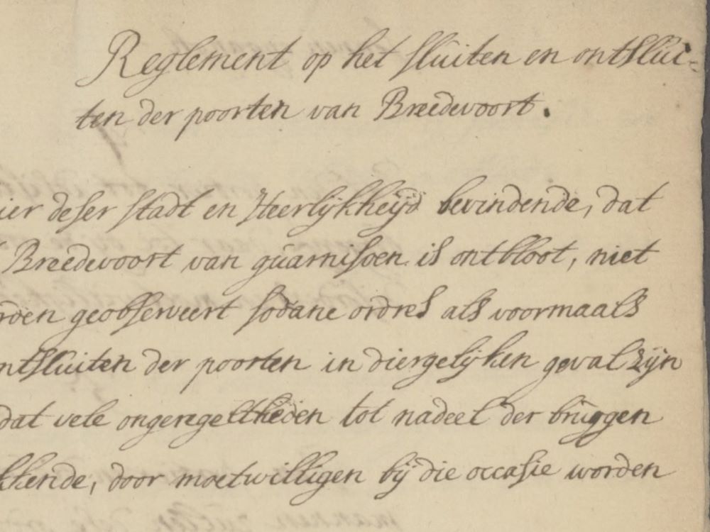
    The text below is a transcription of the “Regulations on the closing and opening of the gates of Bredevoort” from 1759.

    The Officer of this town and Lordship, finding that since this town of Bredevoort has been devoid of a garrison, such orders as were previously given for the closing and opening of the gates in similar cases are not being properly observed, and even that many irregularities detrimental to the bridges and gates are being committed by malicious persons on those occasions1.

    Therefore, in order to provide for this as much as possible, the following regulations on the closing and opening of the gates are hereby decreed and established, as is done by these presents in the following manner:

    1. That in the evening at nine o’clock, after the ringing of the gate bell, the gatekeeper at the outermost bridge shall be required to call out three times whether anyone is still outside, and wait until those who have answered his call have been able to enter properly, and not close the gates before then; without anyone being admitted after that time, except for significant2 reasons. And after the closing has been completed, the keys shall immediately be brought by the gatekeeper to the house of the Mr. Land Writer pro tempore steward3.
    2. The gatekeeper shall put the gates on the bolt or latch one hour after sunset and, before opening, may and shall be entitled to demand half a stiver from every passenger, one stiver from a cart and horse, and two stivers from a wagon, including the driver. And at nine o’clock, after the ringing of the bell, they must be closed entirely, as mentioned in the previous article.
    3. That also in the morning the gates shall be opened half an hour before sunrise.
    4. That the gatekeeper shall have four men from the citizenry for assistance, to be summoned for that purpose by the rotmeesters (squad leaders) each time, to prevent all disorders and acts of malice.
    5. The gatekeeper and the men summoned for that purpose by the Rotmeesters shall strictly follow this order in the closing and opening of the gates and the raising of the bridges at the precise time in the morning and evening, on penalty4 of 6 stivers to be forfeited by each person who is absent and not present at the appointed hours, each time for the benefit of those present.
    6. That besides the gatekeeper and assistants, no one, whoever they may be, shall dare5 to interfere with the closing and opening of the gates or the raising and lowering of the bridges, to lay hands upon them, or to commit even the slightest act of malice, on a fine of two gold guilders to be forfeited by each and every one of the offenders6, with parents being responsible for and paying the fines for their children.
    7. And so that all the aforementioned shall be observed all the more exactly, the gatekeeper and assistants are recommended and at the same time ordered to pay close attention to all the aforementioned, and to report those offenders immediately, for which they shall benefit from one-third of the fine mentioned in the previous article.
    8. That this order shall be observed provisionally for as long as this town shall be devoid of a garrison.

    And an extract of this shall be given to the gatekeeper for his information7.

    And so that no one may plead the slightest ignorance of this, it shall be published and posted where it is customary to do so.

    Thus provisionally decreed within Bredevoort on June 11, 1759.

    By order of the Officer.

    Footnotes


    1. Occasion ↩︎
    2. Honorable, virtuous ↩︎
    3. Mr. Land Writer (secretary) and temporary steward ↩︎
    4. Punishment, fine ↩︎
    5. To dare ↩︎
    6. Offender ↩︎
    7. Notice ↩︎

    Sources


  • Gatekeeper Regulations Bredevoort 1726

    Gatekeeper Regulations Bredevoort 1726

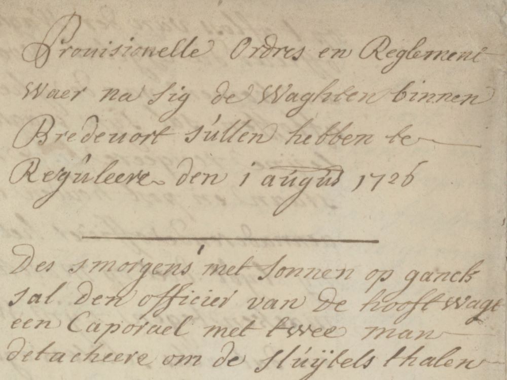
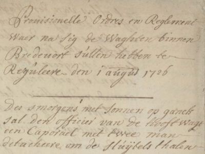
    The text below is a transcription of the original handwritten regulations, as literal as possible, including variations in spelling, but with added punctuation to improve readability. The text contains a number of words or concepts that we did not recognize (highlighted in yellow) and may have been misinterpreted. Therefore: errors excepted and corrections are welcome.

    Provisional Orders and Regulations according to which the guards within Bredevoort shall regulate themselves, August 1, 1726.

    1. In the morning at sunrise, the officer of the main guard shall detach a corporal with two men to fetch the keys.
    2. When the keys arrive, the officer shall arrange the guard under arms, have the march beaten, and detach the sergeant and as many men as shall be necessary. And at the Munsterspoort, the sergeant shall detach the corporal so that every time a drawbridge is lowered and the keys have passed, it is raised again until the field is scouted and the posts are set out.
    3. The gates being opened, the keys shall be returned in the same manner as they were fetched.
    4. Upon the changing of the guard, the officer being relieved shall, upon the arrival of the one who is to relieve him, arrange his guard in a line and have the march beaten and hold post until the approaching officer has the body of men he leads1 march up and form a front opposite his guard, and ensures all sentries are relieved and inspects whether anything is missing from the cannons and batteries2 and whether the guardhouses, sentry boxes, and the rampart are cleared of all filth and found in a state fit for duty, and whether the patrol sticks and whatever else is required for the guardhouses are present with the guard, and that the officer being relieved has handed over the orders observed at his post to the relieving officer. When all this is done and the sentries are relieved and have joined the guard, the relieved officer shall march off to the market and there thank the men; at the same time that the relieved troop marches off, the relieving officer, having arranged his men in a line, shall beat the march and take up post in the same place.
    5. The sergeants of the guard shall remain at their posts for 24 hours. From the main guard only two men, and from the Munster Gate only one, may be given leave to fetch food, but from the opening of the gates in the morning until eight o’clock, as well as during the time when the sentries are relieved, none.
    6. No soldiers are to be allowed outside the gates without a gate pass, written or signed by the Commander; the gate passes shall be held by the officer and, when the soldier returns, given back; if they do not return and the passes are collected, they shall be brought to the Commander with the evening report. The sergeant of the Munster Gate shall send the collected passes to the main guard.
    7. The guards and sentries shall take good care that no damage is done to the timber or palisades on the national fortifications, nor any fishing done in the moats around, or grass mown on the ramparts or counterscarps, without a note or order from the Commander. Also, the sentries and patrols shall ensure that no elevation occurs on the excavated grounds around the fortifications, nor any trenches shifted, and that no filth is made on the ramparts.
    8. The commanding officer of the main guard shall have all foreign passengers brought to the commander. The sergeant of the Munster Gate shall have the same brought to the main guard, but for persons of quality, he shall ask the servants for their names and status and where they are staying, and if they have no servant with them, he shall ask them directly and immediately inform the Commander.
    9. In the afternoon from twelve to one o’clock and on Sundays during the sermon, the outermost drawbridges at the gates shall be raised.
    10. The officer shall provide a written report to the Commander at twelve o’clock in the afternoon and in the evening after the closing of the gate. The parole and orders that may have been given to the guards that day residing there in the morning when relieved shall be reported verbally. The sergeant of the Munster Gate shall have a report made to the officer of the main guard at half past eleven in the morning, in the evening before the gate closes, and in the morning after the opening of the gate.
    11. The sentries both at the barriers and on the ramparts shall call out to and warn one another when they see more than two or three men with arms, or more people than usual, approaching from outside. The sentries at the barrier shall immediately close it and raise the bridge, calling to the nearest sentry to have the guard come to examine the situation and report to the Commander as found. The guard shall ensure that a capable man is always stationed at the barriers.
    12. No foreign passengers shall be allowed on the ramparts or works without special order from the Commander. The sentries shall also take heed that no one enters the faussebraye, and also that no disorder occurs outside or near their posts, such as the breaking of lines placed in the gardens, and they shall always carry their arms while walking and not smoke tobacco.
    13. No foreign beggars shall be allowed into the city, and if any deserters should arrive very early in the morning, they shall remain in the main guard until they have been examined by the Commander.
    14. The sentries shall not allow more than one at a time of the carts or wagons coming from outside to pass over the bridge. Also, no carts or wagons may be left standing before the guard or inside the gate, but a clear space must always be kept, both before the guard and the gates; care must also be taken that the national boat lies locked, inspecting it before the closing of the gates.
    15. No beasts or horses are to be allowed on the fortifications; if any are found on the national works, they shall be brought to the guard and the release fee paid, according to the order of their Noble Mightinesses.
    16. The Ceremonial is to be observed according to the Regulations.
    17. In the evening at sunset, the officer, as a warning to the people who still wish to go out or in, shall have the roll-call beaten and detach a corporal with two men to fetch the keys. And when they arrive, the officer shall arrange the guard under arms, have the march beaten, and continue this until the gates are closed, and then set out the night posts and send the keys back to the Commander. Just as they were fetched when the gates were opened and closed, the officer himself shall be present to ensure that the gates are properly closed.
    18. If a gate is opened at night, the officer shall take care that nothing other than the wicket of the barrier is opened and that once the keys have passed, it is closed again, just as as soon as the keys are over the drawbridge, it is immediately raised again, detaching the necessary men for that purpose. The wicket of the outermost barrier being opened, he shall have it inspected who is outside the gate and, if found to be in order, shall allow those for whom the gates were opened to enter, but taking care that no barrier is opened nor drawbridge lowered before the outermost is well closed and the officer is informed of what has occurred. For the Munster Gate, a corporal with four men from the main guard shall come.
    19. The tattoo shall be beaten at half past nine in the summer and at nine o’clock in the winter.
    20. In the evening, the officer shall have a corporal and two men inspect the inns and have the soldiers of the garrison go to their quarters; half an hour later, he shall inspect them again to see if any had dared to come there, and if so found, they shall be brought to the guard under arrest.
    21. The corporals shall bring their sentries to their posts themselves by day and by night and ensure that the orders given are properly handed over at their posts; to that end, the corporals of the main guard shall inspect the sentry at the bastion, marching up as the sentries of his guard are relieved around the rampart, ensuring that everything is in good order and that no damage is done to the national works. The corporal at the Munster Gate shall march up with the sentry at the Mill Bastion and so forth, observing the rampart all around. What is mentioned in this article, and especially that the sentries of the Munster Gate are relieved at the stroke of eleven, they shall for that purpose stand the first posts from nine to ten o’clock in the morning and then relieve every two hours, namely from ten to twelve and so on.
    22. The officer of the main guard shall send a man around the rampart every two hours, namely at half past ten, half past twelve, half past two in the morning and subsequently every two hours by day and by night, to ensure that no damage is done to the national works, whether by children whom he shall order off the rampart, or dogs or chickens or other harmful creatures which he shall shoot dead. This article shall also be observed by all corporals and sentries performing relief. The sergeant of the Munster Gate shall send a man around the rampart every two hours by day and by night, namely at half past eleven, half past one, half past three in the afternoon and subsequently every two hours.
    23. The officer of the guard shall be responsible for ensuring that every sentry at his post knows all the orders that have been given so that they are properly executed3. To this end, the officers of the main guard shall inspect the posts of both the main guard and the Munster Gate and instruct them on all orders, just as the sergeant of the Munster Gate shall instruct his sentries and visit their posts, for which he shall be held accountable.
    24. The officer on guard shall perform the grand round before twelve o’clock at night. The sergeant of the Munster Gate shall perform the visiting round between twelve and three, and the sergeant of the main guard shall perform the day round before the reveille.
    25. The Commander or major, wishing to inspect the posts by day or by night, shall not need to go to the guard first but shall take with them the sentry for the Commander, who may be relieved for that time.
    26. In case of alarm or fire, the Commander is to be informed immediately, and in the meantime, the officer of the guard shall detach the sergeant with six men there. The guard that is to mount shall first report to the main guard and the Company at the parade ground on the Sand.
    27. All further orders not specified herein shall be regulated according to the ordinances and regulations established of old.
    28. Article 21 of the guard is to be changed in so far that the sentries shall be relieved every hour at night and this shall continue until the guards are relieved in the morning; at the Aelterpoort to begin at eleven o’clock in the evening, until 12, until 1, until 2 and so on from hour to hour; at the Munster Gate to begin at half past ten in the evening, half past eleven, half past twelve and so on from hour to hour.
    29. The officer of the guard shall ensure that the corporals themselves bring the sentries to their posts. And the corporals of the guards shall keep their route around the rampart from each gate, as ordered in Article 21, taking care that if a sentry is not found alert at their post, they shall be relieved and placed under arrest.

    Finis Coronat Opus

    Footnotes


    1. Leads ↩︎
    2. A battery is a group of cannons or artillery, positioned at a strategic location to defend the fortress. ↩︎
    3. Executed ↩︎

    Sources


  • Bredevoort Gunpowder Tower Disaster

    Bredevoort Gunpowder Tower Disaster

    Gunpowder Tower Disaster Bredevoort 1646, 3D impression by Paul van Druten

    On Sunday, July 12, 1646, around four o’clock in the afternoon, the gunpowder tower of Bredevoort Castle, containing 320 barrels of gunpowder, was struck by lightning. Forty people were killed and an unknown number were injured in the ensuing explosion.

    The tower caught fire upon impact. The explosion was so violent that the Ambthuis (administrative house) also collapsed. The town suffered extensive damage from the explosion, and almost all houses lost their roof tiles and windows. The houses surrounding the castle had collapsed. For three days, survivors were sought beneath the rubble using shovels and pickaxes.

    In 1938, G.H. Rots wrote a series of articles in the Aaltensche Courant about the history of the municipality of Aalten. Regarding the gunpowder tower disaster in Bredevoort, he wrote:

    “The year 1646 was once again a disastrous year for Bredevoort. It was the 12th of July, and an oppressive heat hung over the town. Dark clouds gathered, and everything indicated that a severe thunderstorm was imminent. And indeed, lightning soon cleaved the sky, followed by heavy claps of thunder. And suddenly, a terrible blow, followed by a dreadful sound.

    Lightning had struck the gunpowder tower, causing the gunpowder present (320 tons) to explode. The entire tower was blown apart, as was the nearby Ambthuis; tiles were torn from almost all houses, and windows were blown in by the air pressure. The number of deaths in that disaster amounted to 19 at the castle and the Ambthuis alone. There were also numerous deaths in other houses in the town.”

    Victims

    “The deceased included, among others, the Governor of the city Willem van Haersolte and his spouse, the Drostinne Cathrijne van Brakel and her eight children, and her niece Berentjen van Brakel. Furthermore, Joh. van Langen, lieutenant to Georg Ernst Count of Bronkhorst, and also his French mistress (sic) Jeanne van Sédan. An elderly woman present there, Maria Glazen, along with the manservant and the maid, were also among the victims.

    The sentry on duty, named Hendrik Otterpoëll, was buried under the ruins. In other parts of the town, the house of Jan Stenneken was destroyed. He and his wife Marycken van der Halle were killed. The names of the dead in other parts of the town were Derk Trix, ensign, Harmen ter Male, F. zum Moorelagen, Bailiff of Winterswijk, and his wife Janne Beerninck, with her sister Christine Beerninck, widow of the late N. Brinkhorst, judge of Haaksbergen.

    The house of Berent Grimme was destroyed; his wife and four children lost their lives. The house of Casper Evers was hit, under which three people were killed, named Arent Hamaeker, a child of Berent Maes, and a child of Herman Broekman. Under the house of Derrick ter Woerle Wiltschut, three of his children were killed, as well as the soldier Gerrit Jansen and Jan Schulten.

    We have specifically mentioned these names because one might perhaps derive names of those living today from them.”

    The deceased who lay under the rubble of the Ambthuis were laid out on July 15 at the home of the widow of the late minister D.J. Verhagen. The bailiff with his wife and eight children were buried on the morning of Thursday, July 16, in the choir of the St. George’s Church. It is not clear how many people remained under the rubble. In total, forty people died that day. The sources make no mention of the number of victims who were injured.

    One son of Drost Wilhelm van Haersolte survived the disaster. Anthony, as he was named, happened not to be home that day: he was staying in Zwolle. He continued the family line in Zwolle and founded the Haersolte Almshouse there, which is assumed to be connected to the disaster in Bredevoort.

    Sources


    • ‘From Aalten’s past’, by G.H. Rots, Aaltensche Courant, 18 February 1938 (Delpher)
    • Wikipedia
  • Capture of Bredevoort (1572)

    Capture of Bredevoort (1572)

    The Capture of Bredevoort in 1572 was the conquest of the fortified town of Bredevoort by a Sea Beggar (Geuzen) army led by William van den Bergh during the Eighty Years’ War. The siege lasted from 9 June to 20 June and resulted in the successful seizure of the town by the besieging forces. This operation was part of William of Orange’s second invasion, aimed at opposing the ‘Spanish’ Army of Flanders.

    During the Eighty Years’ War, Bredevoort was under Spanish authority. However, from the autumn of 1570, rumours circulated in the Achterhoek of an imminent attack by insurgents, known as the Geuzen. Until 1572, this remained merely a threat. Following the Capture of Brielle on 1 April 1572, Count William van den Bergh, the brother-in-law of William of Orange, assembled an army of approximately 5,000 men in Wesel. His objective was to undertake a campaign through the Achterhoek and along the IJssel. This campaign was marked by the plundering of churches and monasteries, among other targets.

    Siege

    On 9 June, a trumpeter appeared before the city gate to demand the town’s surrender on behalf of William of Orange. The choice was simple: swear an oath of allegiance to the Prince, or face battle. The demand was accompanied by harsh warnings; should they choose to fight, the town would face an assault in which neither property nor life would be spared. The Drost (Bailiff), Jasper van Broeckhuijsen, replied that they first wished to await the opinion of the pandheer (mortgage holder), Dirk van Bronkhorst-Batenburg.

    Meanwhile, William van den Bergh captured the city of Zutphen the following day and sent letters to the towns that had not yet been conquered, inviting them to Zutphen to swear the oath to the Prince. The Bailiff of Bredevoort advised the citizens to go, but this advice was not followed.

    Van Broeckhuijsen eventually managed to convince the pandheer in Anholt that Bredevoort was incapable of defending itself against such superior numbers. Van Broeckhuijsen then travelled to Zutphen to negotiate. On 19 June, a treaty was concluded in which the house, town, and lordship were surrendered to the Prince, though the pandheer would retain his rights.

    Capture

    On 20 June, Bredevoort was captured and occupied by Gisbert van Heerde and his regiment of French troops. Jasper van Broeckhuijsen and all officials of the lordship were dismissed, and Jacob van der Capellen was subsequently installed as the new Bailiff. The remainder of the army advanced westward to capture Doetinchem. However, peace was short-lived.

    In the meantime, Don Frederick was approaching with a large army for a punitive campaign, and by November, Bredevoort was once again a theatre of conflict. On 20 November, Jacob van Bronkhorst, son of the Lord of Anholt, retook the town for the pro-Spanish forces of the Duke of Alba and his son Don Frederick. A month later, the Geuzen plundered Bredevoort Castle, the Schaer Monastery, St George’s Church, and the St James’s Church in Winterswijk.

    Following the Massacre of Zutphen, Van den Bergh fled to Germany, accompanied by the Geuzen who had been stationed in Bredevoort. They took five cannons and ammunition from the town. The pandheer Dirk van Bronkhorst-Batenburg now openly declared his Spanish sympathies. Bredevoort would remain under the Spanish flag until the siege of 1597 by Maurice of Nassau, the future Prince of Orange.

    Source


  • Fortified Town Bredevoort

    Fortified Town Bredevoort

    The fortified town of Bredevoort has a history dating back to (at least) the year 945. At that time, Bredevoort was nothing more than a passable crossing amidst a largely impenetrable swamp. It was, however, a very important passage, as Bredevoort was situated on the major trade route from Bocholt to Zutphen.

    In the 13th and 14th centuries, Bredevoort developed further into an important fortified town. In 1350, Bredevoort was granted minting rights, and in 1388, it even officially received city rights, marking the first mention of the city of Bredevoort: ‘onse borch, huys ende stat tot Bredervoert‘ (our castle, house, and city at Bredevoort).

    During the Eighty Years’ War (1568-1648), Bredevoort became involved in the fighting between the States and Spanish troops and was besieged and captured several times. After the siege by Maurice of Nassau (the later Prince of Orange) in 1597, a strong States garrison was stationed in the town. The bond with the Dutch Royal House has remained consistently strong over time. King Willem-Alexander still holds the official title ‘Lord of Bredevoort’.

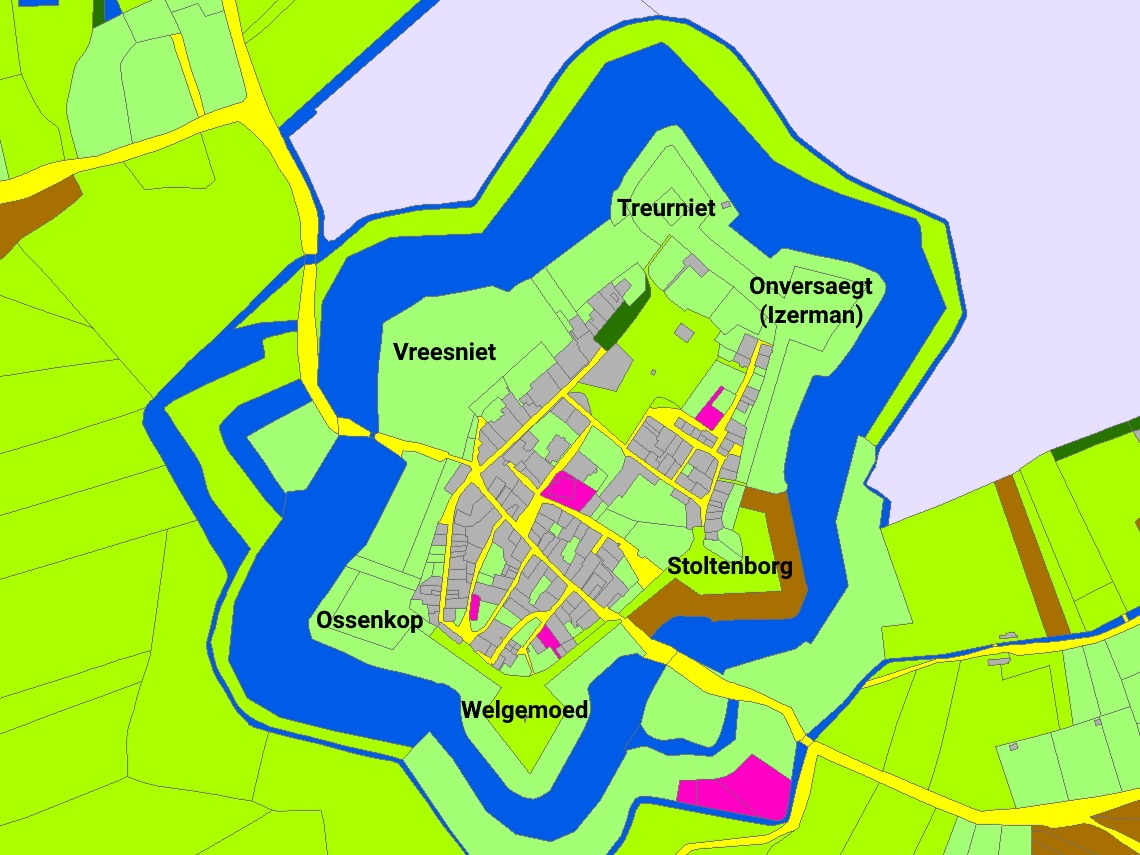
    The garrison town of Bredevoort became part of the eastern line of defense, and plans were subsequently made to reinforce the city. The fortress was strengthened and enlarged; a wide moat was constructed around the six bastions: Vreesniet, Treurniet, Onversaegt, Stoltenborg, Welgemoed, and Ossenkop.

    The remains of the fortifications on the north-western side of Bredevoort were designated as a National Monument in 1967 (numbers 6874 and 6875).

    Historical Description

    In 1938, G.H. Rots wrote a series of articles in the Aaltensche Courant regarding the history of the municipality of Aalten. He wrote the following about the Bredevoort fortress:

    “The historian Sloet mentions that ‘Breitenfurt’ was already spoken of in 945. In old documents, one also reads of ‘Breitenfurt’, ‘Breyden-Oort’, ‘Bredevoorde’, or ‘Breevoort’. In daily conversation, it is still sometimes called ‘Brevoort’. The word itself indicates a connection of higher grounds over low grounds, water, marshes, etc. For all around Bredevoort was low land, full of reeds and rushes, which was passable during very dry summers, and even then only on the highest parts. And there, between those marshes, was a raised mound upon which the strong fortress ‘Breevoort’ was built in earlier times. In diameter, it was approximately 300 meters, or about 10,000 m2. But a great deal has transpired on that small spot over the centuries.”

    In the year just mentioned, 945, the town had to pay eight ounces of silver annually to the monastery in Fulda. Because the fortress was surrounded by marshes, it was one of the strongest strongholds and nearly impossible to capture. There were two access roads: the ‘Aalterpoort‘ on the north-west side, roughly where the Roman Catholic school stands today. The road through the Koppele was only constructed in the last century. Before then, one always had to take the detour around the Koppele. In the east was the ‘Misterpoort‘. Some writers also refer to it as the ‘Münsterpoort’.

    The Lordship of Bredevoort included the jurisdictions of Aalten, Winterswijk, and Dinxperlo and was originally the possession of the bishops of Utrecht. One of the bishops, named Godefroy van Rhenen, founded the castle at Bredevoort, which stood on the site where ‘t Zand is now located. To this castle or court belonged several manorial estates, including the Havezate de Pol near Aalten. Several contributions regarding this manorial system and related matters have appeared, including in Mr. J. A. Nijhof’s book ‘Bijdrage tot de Vaderlandsche Geschiedenis’ (Contribution to National History), and it is also discussed at length in B. Stegeman’s well-known book ‘Het kerspel Winterswijk’. Anyone wishing to know more should consult that book in the library of the Gebr. de Boer company.

    In 1238, the Counts of Loon came into possession of the Lordship. One of those counts, Herman van Loon, transferred the property as a fief in 1246 to Otto van Nassau, Count of Gelre and Zutphen. In the Battle of Tekelenburg in 1276, Herman van Loon was victorious; he captured his opponent, Count Engelbert van der Mark, and took him to the castle at Bredevoort.

    That Count van der Mark soon met his end there; he died of boredom and homesickness. His son, however, Everhard van der Mark, took revenge and captured Bredevoort in 1278, destroying the castle and subsequently transporting his father’s body to Kappenberg. Through the intervention of the Bishop of Münster, Everhard, a peace treaty was soon established between Count Everhard van der Mark and Herman van Loon, in which the Count of Loon pledged not to rebuild the castle until he had made a two-year journey to the Holy Land (the days of the Crusades).

    A short time later, another transaction seems to have taken place, for in 1284 the owner was Baldewinn van Steinfurt, who sold half of the property—namely the northern part of the castle with the associated lands in Aalten—to Bishop Everhard of Münster. However, the lineage of the Counts of Loon became extinct at the beginning of the 14th century, and when the last descendant was carried to the grave, discord arose over the inheritance. The then Bishop of Münster, Ludwig, and Reinald of Gelre both laid claim to the inheritance of the Counts of Loon. It even came to fighting, and both aforementioned potentates brought their armies into battle array, fighting each other to the death.

    Reinald of Gelre had his sights set on Bredevoort, and in 1326, he entered the fortress victoriously. Peace was signed at Coesfeld, and by that peace treaty, Bredevoort became the property of Reinald of Gelre. In 1388, the Lordship was transferred as a pledge to Hendrik van Gemen, who had to pay the sum of 3,000 French shields, which was approximately 6,300 guilders in Dutch currency.

    Later, with the consent of the States of Gelderland, the pledge was transferred to Jacob van Bronkhorst, Lord of Anholt. Finally, in 1580, the Lordship was transferred as a pledge to Prince William I. His successors continued this possession in the same manner. Finally, in 1732, upon the division of the inheritance of William III between the King of Prussia and William Charles Henry Friso, the Lordship of Bredevoort was awarded to the latter. It then formed part of the domains of the House of Orange-Nassau under the management of a steward, who reported annually to the Prince’s councilors and auditors.

    The Prince appointed a drossaard (bailiff), as well as a judge with their deputies. A stadtholder, land scribe, and advocate-fiscal were also appointed. Every fortnight, a court day for civil matters was held in the Lordship for the four jurisdictions mentioned above. The courts consisted of the drossaard or his deputy, the land scribe or secretary, and two assessors or ‘keurnooten’. Furthermore, the government of the city of Bredevoort rested with two mayors.

    As we have already noted, Bredevoort was a strong fortress due to its natural location. In addition to the castle, there were very good bastions. (A ‘gabion book’ of the former fortress is still kept in the State Archives depot in Arnhem. Anyone wishing to know more details should go and browse there).

    While Bredevoort was a strong fortress due to its natural location, it was not a walled fortress until 1545. The well-known and famous commander Maarten van Rossum ensured that the fortress was further reinforced. Around the aforementioned year, he had the moat dug and a rampart constructed. The portion of the moat that still exists was therefore dug nearly 400 years ago. It must have been incredibly busy around the fortress. A few years ago, to combat unemployment, a large part of the moat was filled in with soil from the raised ramparts. A small piece of the rampart has been preserved as a historical site.

    Inside the gates, the situation was also different than it is today. There were narrow streets and alleys. In the cellars of many houses, there were escape or shelter tunnels. During the demolition of an old cellar a few years ago, such a shelter tunnel was revealed. It is also claimed that there was an underground passage from ‘t Walfort Castle to Bredevoort. During previous excavations at ‘t Zand, such a passage is said to have been discovered. However, people did not dare to venture far into it due to the foul or toxic air present. It would be worthwhile to pay attention to this when digging sewers. That there were underground shelters is certain, but we doubt the existence of a connecting road as mentioned above.

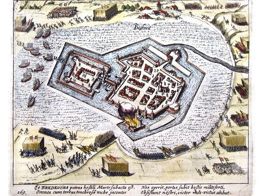
    The noise of war and military activity echoed within the fortress for centuries. Even into the 18th century, three companies of infantry were garrisoned in Bredevoort under the command of a commander, who had a major under him. Especially during the Eighty Years’ War, things were intense in and around Bredevoort. In the late sixteenth century, the Spanish held the fortress. On the first of October 1597, Prince Maurice arrived before Bredevoort with his army. He summoned the garrison, which consisted of only two banners of infantry, to surrender. But they replied that they would keep their weapons for God and the King until their final breath. The Spanish relied on the natural strength of the fortress. Prince Maurice then laid siege to Bredevoort.

    As mentioned, there were two access dikes to Bredevoort, but Prince Maurice had a third access road constructed through the Koppele. That road through the marsh was made with sand and brushwood. The sand was brought in bags by the soldiers. In just 8 days, that road, 500 paces in length, was completed. It was then possible to take a height across the moat, suitable for placing 20 pieces of artillery. A murderous fire was then opened upon the fortress. But the besieged defended themselves bravely, and many attackers were killed.

    The fortress walls suffered greatly from the cannon fire, and several cracks and breaches had already appeared, yet the garrison still did not surrender. The moat was an obstacle to bringing troops to the front of the ramparts and walls. But Prince Maurice was resourceful, and he had his men build a floating bridge, a kind of cork or rush bridge. This was placed in the moat, providing access to the rampart and creating two points of attack. Count Solms led that attack on the eastern side, from the direction of the Broek. But the resistance was not yet broken. The besieged returned the enemy fire with cannon and muskets. The besiegers were also pelted with stones, and many stormers bit the dust. But it could not last much longer; the attacks became increasingly fierce until finally, a drummer from the city appeared on the wall and gave a signal that they wished to negotiate. But an enemy bullet struck him, and the drummer, who came with peaceful intentions, was killed by a bullet.

    The inhabitants of the fortress renewed the attempt to negotiate. They held up sticks with hats, but the besiegers paid no attention to this. Then the women went onto the ramparts to testify to the will to surrender. It is incomprehensible that the besiegers still paid no heed to this. Did they fear a trap, or was it the cruelty of that era that demanded blood? In any case, Maurice’s sailors stormed the stone bastion, entered the fortress, and immediately killed 70 people. The survivors fled to the castle, which was immediately surrendered unconditionally by treaty on October 9th. Prince Maurice spared the lives of all, but stipulated a sum of money for his troops, which was later waived.

    Except for the castle and 20 houses, all buildings, including the church, had burned down. The Spanish commander Domiaan Gardot was granted mercy, although he was initially to be executed. During the Spanish occupation, this Gardot had made himself hated by the citizenry.

    Prince Maurice, who had entered the gates of Bredevoort victoriously, stayed in Bredevoort for only a few days. He moved further north. A few months earlier, he had taken Groenlo, and now he went via Groenlo to the Overijssel region to make conquests there. Bredevoort kept a small garrison, and the population worked with all their might to rebuild the burned houses. But hardly had the building begun when fire broke out again, and of the approximately 20 houses that had been spared during the siege, 14 burned down, leaving only 6 houses.

    There was bitter suffering then. The church had to be rebuilt, but the means were lacking, and letters of appeal were sent to sister congregations for support. However, they did not lose heart. They began rebuilding the church and the burned houses, and gradually the town had habitable houses again. But it was and remained wartime, and dangers threatened from all sides.

    In 1606, the Spanish appeared before the city again. It was Shrove Tuesday, and people wanted to celebrate in the city. The soldiers, in particular, were out on the town. There was celebration and merriment, and the soldiers drank heavily. And while they were having fun, the enemy crept up. The Spanish commander Du Terrail arrived quietly from Oldenzaal with 1,200 men and appeared before the city gates in the evening. The guard was on duty, and they were told that the newcomers were soldiers of Prince Maurice being pursued by the Spanish. They lied to the guard and even claimed they had captured a Spanish lieutenant. They requested permission to stay under the protection of the fortress. The guard sent a message to headquarters, and while deliberations were taking place there, it was realized they had been deceived. The population was already fleeing to the castle, and the Spanish were already storming the gates, blowing them up, and before anyone fully realized what was happening, the enemy army was already entering the town.

    The Shrove Tuesday joy was cruelly disrupted. The Spanish soldiers killed everyone they encountered, including many women. The minister’s wife also fell victim to the killers. The castle, however, offered a safe refuge for the citizens and soldiers who had fled there. The bridge over the moat surrounding the castle was destroyed, making it temporarily safe within the thick walls. The Spanish were fired upon from the castle, and help also arrived from outside. Count Henry of Nassau appeared with an army from Zutphen and other fortresses, and on March 22nd, the Spanish were forced to surrender. The Spanish commander Du Terrail negotiated a free retreat, which was granted to him provided he returned the booty and prisoners that had already been transported to Oldenzaal. The Spanish did not show themselves again, and the worst suffering was over.

    The year 1646 was another year of disaster for Bredevoort. It was July 12th, and an oppressive heat hung over the city. Dark clouds gathered, and everything indicated that a heavy thunderstorm was imminent. And indeed, lightning soon cleaved the sky, followed by heavy claps of thunder. And suddenly, a tremendous blast, followed by a terrible sound. Lightning had struck the gunpowder tower, causing the stored gunpowder (320 tons) to explode. The entire tower was blown apart, as was the nearby Administrative House (Ambthuis); tiles were ripped off almost all houses, and windows were blown in by the air pressure. The number of deaths in that disaster was 19 at the castle and the Administrative House alone. There were also numerous deaths in other houses in the city.

    The year was 1672. War had broken out with the Bishop of Münster and Cologne, England, and France. The general-watchmaster of the Bishop of Münster crossed the borders with 2,000 men and laid siege to Bredevoort. The garrison consisted of 500 men, and 20 pieces of artillery stood on the ramparts. In the warehouse was a stock of 20 lasts of rye and 1,800 barrels of gunpowder. The commander of the garrison, Adriaan van Keppel, had repeatedly asked the Deputies of the County of Zutphen for reinforcements of supplies, but in vain. From June 13th to 18th, the fortress was bombarded. The garrison began to mutiny. The women in the city also began to grumble. Rumors spread that the Prince of Orange had been defeated with his army. Fear took hold of the garrison, and on June 18th, the city surrendered, although according to experts, this had not been necessary. The garrison marched away, and fortunately, no looting occurred.”

    Sources


  • Treaty of Wesel (1326)

    Treaty of Wesel (1326)

    The year 2026 marks exactly seven centuries since the political map of the eastern Achterhoek was drawn. On 28 June 1326, the Treaty of Wesel and an astronomical mortgage sum put an end to the ‘Bredevoorter Fehde’ (the Feud of Bredevoort). Consequently, the Lordship of Bredevoort – including the jurisdictions of Aalten, Winterswijk, and Dinxperlo – came under Guelders control. This is a reconstruction of a bitter, four-year war of attrition that would change the region forever.

    Anyone looking at the national borders around Aalten today will see a historical relic that leads straight back to the Middle Ages. The fact that this region belongs to Gelderland, rather than Germany, is due to geopolitical entanglements in the early fourteenth century. Until 1316, the border area was ruled by the Counts of Lohn. When Count Herman II of Lohn died childless that year, the county vanished, creating a power vacuum around the strategic castle of Bredevoort.

    The post-Lohn vacuum

    Even then, Bredevoort Castle was a flashpoint. Half of it had been held by the Bishopric of Münster since 1284; the other half was inherited by Otto of Ahaus in 1316. Troops belonging to Ludwig II, the Prince-Bishop of Münster, immediately occupied the entire castle. Although the Count of Guelders, Reinald I, also laid claim to the territory, he did not intervene militarily straight away. Instead, he concluded a three-year truce. It was only under his successor, Reinald II, that the conflict escalated into a true status war, with Guelders receiving active support from Count William III of Holland.

    In the summer of 1322, Reinald II managed to capture Bredevoort Castle in a surprise attack. To offset the expenses incurred, he marched through the Münster lands with 700 knights and infantry, plundering as they went. This heralded a ruthless four-year guerrilla war.

    Sleeping knights and a captured bishop

    The conflict was characterised by lightning raids and heavy casualties. One of the most remarkable confrontations took place in March 1323 near the town of Dülmen. A military unit from Borken, supporting the Bishop of Münster, surprised the Guelders army while the knights were asleep. The Borken forces deliberately killed the knights’ horses. Encased in their heavy armour, the Guelders warriors were virtually defenceless without their mounts; 86 knights and squires were killed, and a hundred knights were captured for ransom.

    However, the tables turned quickly. In May 1323, Prince-Bishop Ludwig II of Münster himself was captured by Engelbert II van der Mark, an ally of Guelders. The bishop was only released in November of that year, following the payment of an astronomical ransom of 5,000 silver marks.

    The peace that followed was short-lived. As soon as the bishop was free, he recaptured Bredevoort. By 1324, the armies faced each other once more near Coesfeld. It had become a full-blown European conflict: Reinald II had assembled an army of 7,000 cavalry, backed by the King of Bohemia, the Counts of Flanders, Holland, Artois, Van der Mark, Jülich, and Van den Bergh, as well as the Bishops of Liège and Utrecht. Münster was supported by troops from Osnabrück, the Lords of Lippe, the Counts of Waldeck and Sayn, and a host of Frisians, Hessians, Thuringians, and Franks.

    As the armies stood face-to-face near Coesfeld, a massive pitched battle loomed. However, King John of Bohemia and Count William III of Holland managed to persuade the sparring factions to reach a compromise, leading to the signing of a treaty on 1 September 1324. The Bishop of Utrecht subsequently delivered a binding, yet nuanced, arbitration on the claims in Deventer. Münster demanded that Guelders renounce its rights to Bredevoort, the Honborn jurisdiction, and the Reken estate. The Bishop of Utrecht ruled that both parties had to defer to the feudal overlord regarding Bredevoort. He was unable to rule on the remaining territories due to ancient feuds, though Münster was awarded 500 marks in damages.

    Since this ruling did not resolve the underlying tensions, the war flared up again unabated in early 1325. This led to the brutal destruction of the Münster-held part of the town of Vreden by Guelders troops on 3 January 1325.

    The Treaty of Wesel (1326)

    By 1326, both sides were financially and militarily exhausted. Mediated by Count Dietrich of Cleves and his brother John, the parties reached a definitive agreement in the Hanseatic city of Wesel.

    The peace terms dictated that Bredevoort Castle was permanently awarded to Reinald II of Guelders. In return, the Count of Guelders had to return the occupied Lordship of Bermentfelde (present-day Barnsfeld near Südlohn) to Münster, in exchange for 3,500 marks in compensation.

    It was here that the decisive financial mechanism came into play: bankrupt from the earlier ransoms and years of warfare, the Bishopric of Münster could not afford to pay these 3,500 marks. As security (a pledge) for this sum, the bishop mortgaged the jurisdictions of Winterswijk, Aalten, and Dinxperlo, along with the corresponding county court (vrijgraafschap), to Guelders. On 28 June 1326, this official peace treaty was signed, co-sealed by the Guelders towns of Zutphen, Groenlo, Arnhem, and Emmerich.

    The legacy of an outstanding debt

    The treaty stipulated that Münster could redeem the pledge — and thus regain governance over the three parishes — at any time by repaying the mortgage sum to the magistrates (schepenen) of Wesel. However, over the following centuries, Münster never managed to raise the funds.

    What began as a temporary mortgage thus became a permanent arrangement. The Lordship of Bredevoort remained permanently part of Guelders territory and later formed the Bailiwick (Ambt) of Bredevoort. The borders of these medieval jurisdictions are still visible today in the municipal boundaries of the eastern Achterhoek. An unredeemed debt from 1326 thus determined that the residents of Aalten, Winterswijk, and Dinxperlo are Gelderlanders today, and not Westphalians.

    Sources


    Archival Sources

    Digital Sources

    • [Compas, T. / Mijn Gelderland] De geschiedenis van de Heerlijkheid Bredevoort. Available via: mijngelderland.nl
    • [Genealogy.net] GenWiki: Amt Ahaus. Available via: genealogy.net

    Printed Sources and Literature

    • Arend, J.P. & Van Rees, O. (1840-1871). Algemeene geschiedenis des vaderlands, van de vroegste tijden tot op heden. Amsterdam: J.F. Schleijer.
    • Nijhoff, I.A. (1830-1875). Gedenkwaardigheden uit de geschiedenis van Gelderland. Arnhem: Is. An. Nijhoff.
    • Rabich, A. (2010). Die Regionalgeschichte von Dülmen und Umgebung. Dülmen: Laumann-Verlag.
    • Schmidt, F. (1903). Die Bredevorter Fehde zwischen Geldern und Münster (1319-1326). Münster: Wulf.
    • Scholz, K. (1995). Das Stift Alter Dom St. Pauli in Münster. Berlin/New York: Walter de Gruyter.
    • Spaen la Lecq, W.A. van (1801-1805). Oordeelkundige inleiding tot de historie van Gelderland (4 delen). Utrecht: Wild en Altheer.
    • Wisplinghoff, E. (1992). Germania Sacra: Historisch-statistische Beschreibung der Kirche des alten Reichs. Berlin/New York: Walter de Gruyter.
  • Bredevoort Castle

    Bredevoort Castle

    Bredevoort Castle, 3D impression by Paul van Druten

    Bredevoort Castle was a fortress in the heart of the eponymous town and former Lordship of Bredevoort in the County of Zutphen within the Duchy of Guelders. It was one of the most significant castles in Gelderland. During the 13th and 14th centuries, Bredevoort Castle played a major role in the struggle between Guelders and Münsterland.

    The castle was first mentioned in 1188 on a list of properties belonging to the Diocese of Cologne as “Castrum Breidervort“. At that time, the castle was a site of contention. Consequently, it had multiple owners, leading to a centuries-long struggle for control. In 1238, the castle came into the hands of Ludolf van Steinfurt and Herman van Lohn as a shared inheritance. The castle was to be fortified, with both parties sharing the costs. In 1278, the fortress was destroyed by Count Everhard I von der Mark during an act of revenge. Following this, the castle remained a ruin for 23 years. A deed of sale from 1284 refers to the “area castri Bredevort”.

    After years of conflict over Bredevoort between Münster and Guelders, the castle eventually returned to the hands of Count Herman van Lohn II in 1301. In that year, the bishops of Münster and Cologne pledged to assist Herman van Lohn with the restoration of the fortress. In the turbulent times that followed, the fortress frequently changed hands between Münster and Guelders through combat or sale. The bishops of Münster and Cologne were required to jointly fund the reconstruction of Bredevoort Castle.

    After centuries of fighting over the castle, the Bishop of Münster abandoned the struggle and sought peace negotiations. Following years of negotiation, peace was finally signed on June 28, 1326, with the Treaty of Wesel. This significant treaty was also signed by the cities of Zutphen, Groenlo, Emmerich, and Arnhem. As a result, Reinoud II of Guelders acquired the pledge of the jurisdictions in Winterswijk, Aalten, and Dinxperlo, as well as the County of Bredevoort. This move definitively incorporated the area into Gelderland.

    Floor plan

    In 1562, the lord of the manor of Bredevoort, Diederik van Bronckhorst-Batenburg, Lord of Anholt, commissioned a floor plan of the castle at Bredevoort. This plan also described the functions and structural condition of the various components. Measurements were recorded in Rhineland feet. A Rhineland foot is over 31 cm long. The castle was a rectangle measuring 42 m long and 36 m wide. The walls were approximately 65 cm thick. An earthen rampart surrounded the castle, with roundels at the corners. The rampart was approximately 2 m wide.

    Explanations of the descriptions on the floor plan (translated from old script):

    1. This vault will collapse if it is not repaired soon.
    2. Here is the staircase leading to the knights’ hall.
    3. This wall is dilapidated. The vertical beams are rotted at the bottom. This is a large hall: 47 feet long and 23 feet wide, measured from the inside. Beneath it is a cellar. The floor consists of beams and planks and is finished with floor tiles. There is only one attic above the hall.
    4. This is a staircase to enter the large hall.
    5. This is the kitchen, 21 feet long and 23 feet wide. Beneath it is a cellar of the same size as the cellar under the large hall.
    6. This shed was built by Drost Isendoorn. The walls are masonry set between beams.
    7. This is the rampart that runs around the castle.
    8. This is a very dilapidated shed, much like a pigsty.
    9. The prison tower. It is 38 feet square (measured from the outside). The walls are 8½ feet thick. [This tower was likely used later as a powder tower, Ed.]
    10. Here are two roundels.
    11. The Drost’s chamber (Maarschalcksekamer) above the gate. [The name ‘Maarschalckse kamer’ dates from the period 1534-1555 when Marshal Maarten van Rossum was Drost of Bredevoort, Ed.]
    12. This is the chapel.
    13. From here, the hearth of the knights’ hall is stoked.
    14. This is the knights’ hall. The room is 36 feet long and 19 feet wide. Below this are the rooms of the burgrave (castle warden) and the steward. The gate entrance is also located below here.
    15. This wall is in good condition, as far as it can be seen above the rampart.
    16. This wall is built between wooden beams and has a thickness of half a brick. [The bricks used were ‘kloostermoppen’ of approximately 14 cm in width, Ed.]
    17. A dilapidated spiral staircase.
    18. Another room. Below this is a laundry room. Because the rampart rests against the laundry room, the wall is rotted. The stones are loose.
    19. This wall is largely built between wooden beams and is very dilapidated.
    20. This contains the grain mill and the baking ovens. Above is the servant’s room, with two attics and a chimney.
    21. This is where the Drost sleeps. The room is 28 feet long and 23 feet wide. Beneath it is a meat cellar.
    22. This room is divided in two. The floor is made of wood. The meat cellar also lies beneath this area.
    23. This upper room is called the salon (state room, armory). Below it is the armor room.
    24. Here the rampart touches the wall, causing the wall to let in moisture and show defects. The wall is very thick, and if the water could be kept out, it would likely provide some improvement.
    25. These two rooms, as well as the granary, are located above the bakehouse and brewhouse.
    26. This drawing was made in Arnhem after everything was measured as accurately as possible. The drawing is fairly accurate. However, in reality, some parts are slightly larger than depicted here, such as the chapel, the spiral staircase in the courtyard, and the prison tower.

    External Appearance

    Not much is known about exactly how Bredevoort Castle looked. While drawings of the castle exist, they are partly based on assumptions and imagination.

    The castle was built on a sandy ridge of approximately 42 x 26 meters, making it one of the larger castles in the Netherlands. Old maps show the main fortress to be a typical concentric castle, featuring double moats and a thick curtain wall. It included an outer bailey with heavy corner towers and a rectangular castle wall equipped with four corner towers, three of which were later lowered to become roundels.

    The castle and the town were separated by a double moat. Access to the castle from the town was via a bridge. One had to pass through two gates, the second of which was equipped with a barbican, and finally a gatehouse in the curtain wall before reaching the inner courtyard. Within the fortress, various buildings stood around a spacious inner court. These depictions changed over time, and the appearance and stature of the castle would have been altered frequently throughout the centuries due to conflict, war, city fires, and other causes.

    Destroyed

    The castle was heavily damaged by the Gunpowder Tower Disaster in 1646. Following this, the castle dominated the cityscape as a ruin for over 150 years until around the end of the 18th century. The last known mention of a visible ruin dates to 1791, recorded in the Bredevoort church council minutes when William V viewed the remains during his visit to Bredevoort. The main building (excluding the outer bailey, roundels, and curtain wall) had dimensions of approximately 42 x 36 meters. This made it one of the larger castles in the Netherlands.

    Remains

    Today, the remains of the castle—in the form of foundations, vaults, tunnels, and rubble—lie beneath and around the ‘t Zand square and the Hozenstraat in the heart of the town. In the spring of 2009, during archaeological research around the former school on ‘t Zand, part of the foundations was uncovered. Wall remains between 2.5 and 4 meters thick were found. On ‘t Zand square, foundations of the barbican were discovered. The contours of this gatehouse have been made visible in the paving with brass-colored bands.

    Sources