The Capture of Bredevoort in 1572 was the conquest of the fortified town of Bredevoort by a Sea Beggar (Geuzen) army led by William van den Bergh during the Eighty Years’ War. The siege lasted from 9 June to 20 June and resulted in the successful seizure of the town by the besieging forces. This operation was part of William of Orange’s second invasion, aimed at opposing the ‘Spanish’ Army of Flanders.
During the Eighty Years’ War, Bredevoort was under Spanish authority. However, from the autumn of 1570, rumours circulated in the Achterhoek of an imminent attack by insurgents, known as the Geuzen. Until 1572, this remained merely a threat. Following the Capture of Brielle on 1 April 1572, Count William van den Bergh, the brother-in-law of William of Orange, assembled an army of approximately 5,000 men in Wesel. His objective was to undertake a campaign through the Achterhoek and along the IJssel. This campaign was marked by the plundering of churches and monasteries, among other targets.
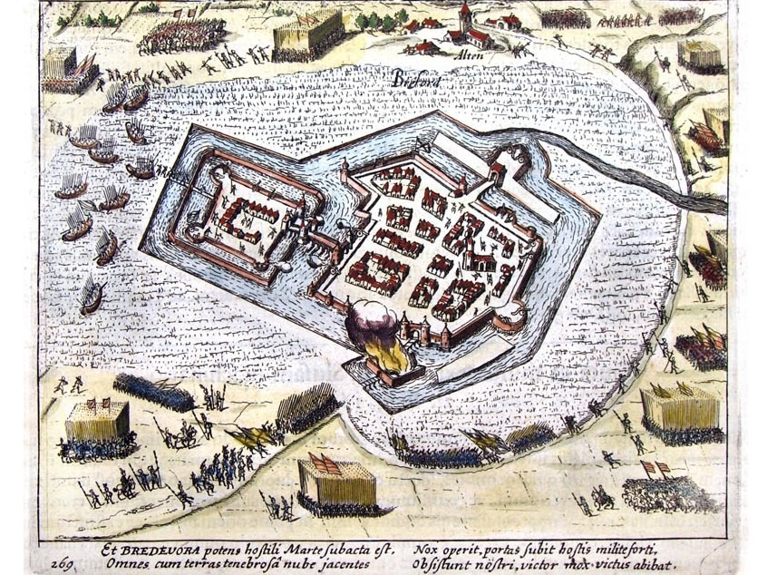
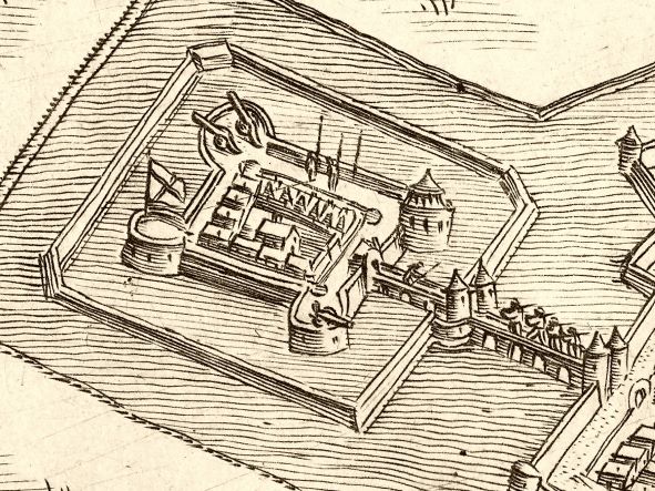
Fortress Bredevoort, etching by Willem Baudartius (1606)
Siege
On 9 June, a trumpeter appeared before the city gate to demand the town’s surrender on behalf of William of Orange. The choice was simple: swear an oath of allegiance to the Prince, or face battle. The demand was accompanied by harsh warnings; should they choose to fight, the town would face an assault in which neither property nor life would be spared. The Drost (Bailiff), Jasper van Broeckhuijsen, replied that they first wished to await the opinion of the pandheer (mortgage holder), Dirk van Bronkhorst-Batenburg.
Meanwhile, William van den Bergh captured the city of Zutphen the following day and sent letters to the towns that had not yet been conquered, inviting them to Zutphen to swear the oath to the Prince. The Bailiff of Bredevoort advised the citizens to go, but this advice was not followed.
Van Broeckhuijsen eventually managed to convince the pandheer in Anholt that Bredevoort was incapable of defending itself against such superior numbers. Van Broeckhuijsen then travelled to Zutphen to negotiate. On 19 June, a treaty was concluded in which the house, town, and lordship were surrendered to the Prince, though the pandheer would retain his rights.
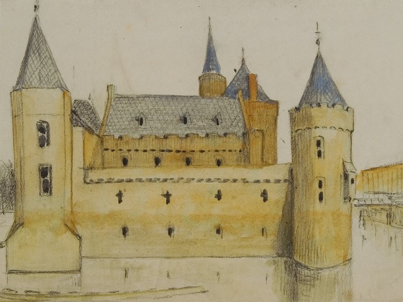
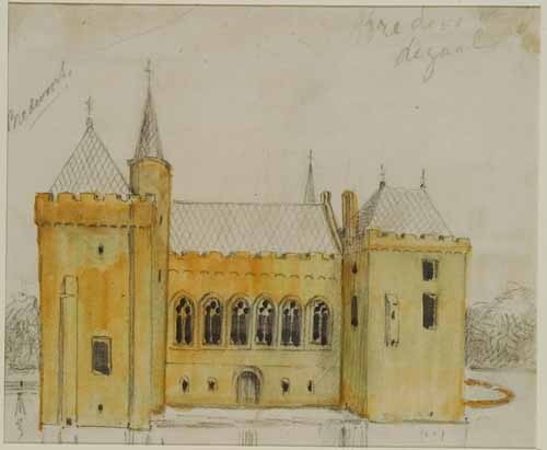
Bredevoort Castle, by Jacobus Craandijk
Capture
On 20 June, Bredevoort was captured and occupied by Gisbert van Heerde and his regiment of French troops. Jasper van Broeckhuijsen and all officials of the lordship were dismissed, and Jacob van der Capellen was subsequently installed as the new Bailiff. The remainder of the army advanced westward to capture Doetinchem. However, peace was short-lived.
In the meantime, Don Frederick was approaching with a large army for a punitive campaign, and by November, Bredevoort was once again a theatre of conflict. On 20 November, Jacob van Bronkhorst, son of the Lord of Anholt, retook the town for the pro-Spanish forces of the Duke of Alba and his son Don Frederick. A month later, the Geuzen plundered Bredevoort Castle, the Schaer Monastery, St George’s Church, and the St James’s Church in Winterswijk.
Following the Massacre of Zutphen, Van den Bergh fled to Germany, accompanied by the Geuzen who had been stationed in Bredevoort. They took five cannons and ammunition from the town. The pandheer Dirk van Bronkhorst-Batenburg now openly declared his Spanish sympathies. Bredevoort would remain under the Spanish flag until the siege of 1597 by Maurice of Nassau, the future Prince of Orange.
The Calvary Mount (Calvarieberg) was reportedly located on the highest part of the ‘Aaltense Es’ (a type of historical communal open field), near the present-day Berkenhove cemetery and the water tower. Historians suspect that in the Late Middle Ages, this spot formed the terminus of a Stations of the Cross featuring thirteen stone stations, which depicted the Passion of Christ.
A Calvary Mount, also known as a Mount of Calvary, is an artificial hill on which the crucifixion of Christ is depicted. The name refers to Golgotha (Calvaria = skull), the hill outside Jerusalem where, according to the Gospels, Jesus was crucified. Calvary Hills were common across large parts of Catholic Europe.
Stations of the Cross
Although the original location of the Aalten stations is unknown, historians believe that in the Late Middle Ages, the Stations of the Cross led upwards from the Oude Helenakerk (Old St Helen’s Church) across the es to Calvary Hill. One theory suggests that the first station stood near the Oude Helenakerk and that the remaining stations were positioned along the sloping path across the Aalten es. By walking from the church past the stations to Calvary Hill, Aalten believers could symbolically follow Jesus’s path to his execution.
The final station is thought to have been located near the current water tower, on one of the highest points in Aalten, which was also situated along the ancient trade route (volkerenweg) between Bocholt and Zutphen.
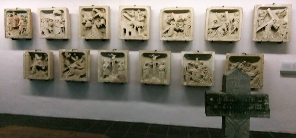
The 13 Aalten Stations of the Cross in the Museum Catharijneconvent in Utrecht
“den Berch van Calvarien”
A file from 1580–1581 has been preserved in the Gelders Archive in Arnhem: an inventory of the possessions of the Nazareth (Schaer) monastery near Bredevoort. Prior Johan van Vueren was commissioned by the Guelders authorities to survey the monastic lands. The possessions of Nazareth had been confiscated during the transition of Guelders to the Reformation. From then on, the revenues were used to fund the training of orthodox Protestant ministers and schoolmasters. On the Aalten Es, north of the village, lay a plot of land, about which Van Vueren noted:
“Master Sander ter Woert with his brother-in-law have (…) a piece of land situated in the Aalten Esche near the Berch van Calvarien, measuring 11 and a half schepel of sown land.”
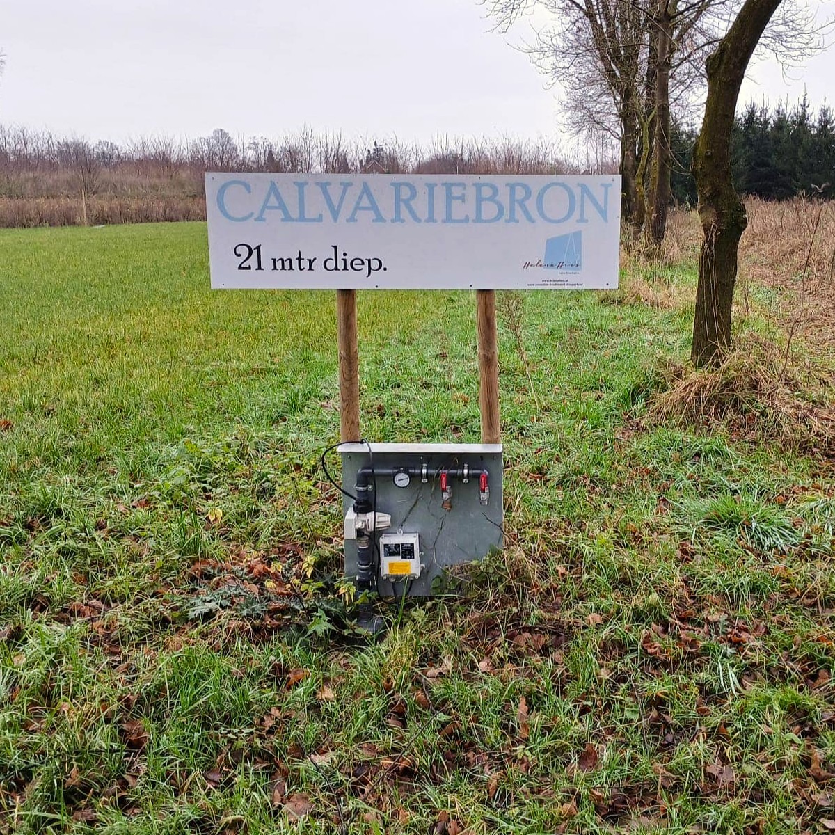
Procession Park
In 2023, plans emerged to create a procession park at the beginning of the Barloseweg, featuring replicas of the Aalten Stations of the Cross and Bible-related vegetation. For the maintenance of this park, a water tap was already installed, which has since been named the ‘Calvariebron’ (Calvary Spring).
The fortified town of Bredevoort has a history dating back to (at least) the year 945. At that time, Bredevoort was nothing more than a passable crossing amidst a largely impenetrable swamp. It was, however, a very important passage, as Bredevoort was situated on the major trade route from Bocholt to Zutphen.
In the 13th and 14th centuries, Bredevoort developed further into an important fortified town. In 1350, Bredevoort was granted minting rights, and in 1388, it even officially received city rights, marking the first mention of the city of Bredevoort: ‘onse borch, huys ende stat tot Bredervoert‘ (our castle, house, and city at Bredevoort).
During the Eighty Years’ War (1568-1648), Bredevoort became involved in the fighting between the States and Spanish troops and was besieged and captured several times. After the siege by Maurice of Nassau (the later Prince of Orange) in 1597, a strong States garrison was stationed in the town. The bond with the Dutch Royal House has remained consistently strong over time. King Willem-Alexander still holds the official title ‘Lord of Bredevoort’.
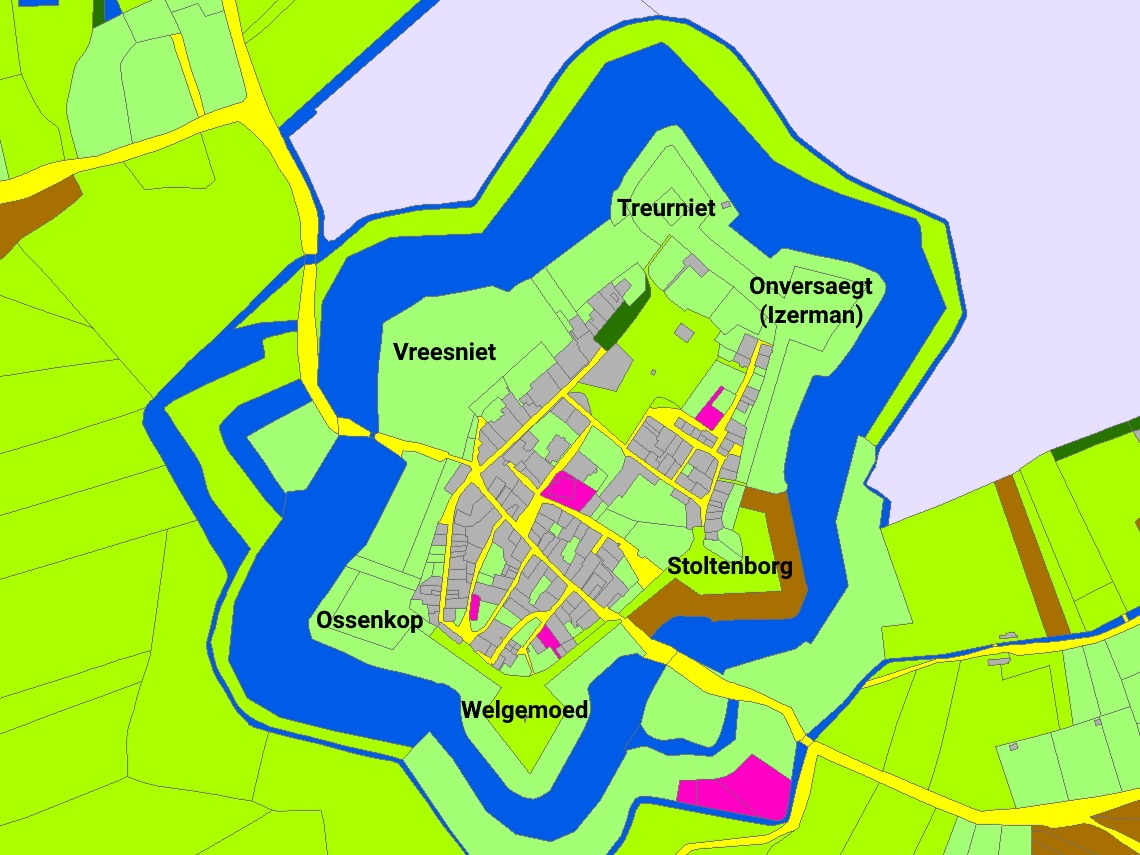
Bastions of Bredevoort, map: hisgis.nl
The garrison town of Bredevoort became part of the eastern line of defense, and plans were subsequently made to reinforce the city. The fortress was strengthened and enlarged; a wide moat was constructed around the six bastions: Vreesniet, Treurniet, Onversaegt, Stoltenborg, Welgemoed, and Ossenkop.
The remains of the fortifications on the north-western side of Bredevoort were designated as a National Monument in 1967 (numbers 6874 and 6875).
Historical Description
In 1938, G.H. Rots wrote a series of articles in the Aaltensche Courant regarding the history of the municipality of Aalten. He wrote the following about the Bredevoort fortress:
“The historian Sloet mentions that ‘Breitenfurt’ was already spoken of in 945. In old documents, one also reads of ‘Breitenfurt’, ‘Breyden-Oort’, ‘Bredevoorde’, or ‘Breevoort’. In daily conversation, it is still sometimes called ‘Brevoort’. The word itself indicates a connection of higher grounds over low grounds, water, marshes, etc. For all around Bredevoort was low land, full of reeds and rushes, which was passable during very dry summers, and even then only on the highest parts. And there, between those marshes, was a raised mound upon which the strong fortress ‘Breevoort’ was built in earlier times. In diameter, it was approximately 300 meters, or about 10,000 m2. But a great deal has transpired on that small spot over the centuries.”
In the year just mentioned, 945, the town had to pay eight ounces of silver annually to the monastery in Fulda. Because the fortress was surrounded by marshes, it was one of the strongest strongholds and nearly impossible to capture. There were two access roads: the ‘Aalterpoort‘ on the north-west side, roughly where the Roman Catholic school stands today. The road through the Koppele was only constructed in the last century. Before then, one always had to take the detour around the Koppele. In the east was the ‘Misterpoort‘. Some writers also refer to it as the ‘Münsterpoort’.
The Lordship of Bredevoort included the jurisdictions of Aalten, Winterswijk, and Dinxperlo and was originally the possession of the bishops of Utrecht. One of the bishops, named Godefroy van Rhenen, founded the castle at Bredevoort, which stood on the site where ‘t Zand is now located. To this castle or court belonged several manorial estates, including the Havezate de Pol near Aalten. Several contributions regarding this manorial system and related matters have appeared, including in Mr. J. A. Nijhof’s book ‘Bijdrage tot de Vaderlandsche Geschiedenis’ (Contribution to National History), and it is also discussed at length in B. Stegeman’s well-known book ‘Het kerspel Winterswijk’. Anyone wishing to know more should consult that book in the library of the Gebr. de Boer company.
In 1238, the Counts of Loon came into possession of the Lordship. One of those counts, Herman van Loon, transferred the property as a fief in 1246 to Otto van Nassau, Count of Gelre and Zutphen. In the Battle of Tekelenburg in 1276, Herman van Loon was victorious; he captured his opponent, Count Engelbert van der Mark, and took him to the castle at Bredevoort.
That Count van der Mark soon met his end there; he died of boredom and homesickness. His son, however, Everhard van der Mark, took revenge and captured Bredevoort in 1278, destroying the castle and subsequently transporting his father’s body to Kappenberg. Through the intervention of the Bishop of Münster, Everhard, a peace treaty was soon established between Count Everhard van der Mark and Herman van Loon, in which the Count of Loon pledged not to rebuild the castle until he had made a two-year journey to the Holy Land (the days of the Crusades).
A short time later, another transaction seems to have taken place, for in 1284 the owner was Baldewinn van Steinfurt, who sold half of the property—namely the northern part of the castle with the associated lands in Aalten—to Bishop Everhard of Münster. However, the lineage of the Counts of Loon became extinct at the beginning of the 14th century, and when the last descendant was carried to the grave, discord arose over the inheritance. The then Bishop of Münster, Ludwig, and Reinald of Gelre both laid claim to the inheritance of the Counts of Loon. It even came to fighting, and both aforementioned potentates brought their armies into battle array, fighting each other to the death.
Reinald of Gelre had his sights set on Bredevoort, and in 1326, he entered the fortress victoriously. Peace was signed at Coesfeld, and by that peace treaty, Bredevoort became the property of Reinald of Gelre. In 1388, the Lordship was transferred as a pledge to Hendrik van Gemen, who had to pay the sum of 3,000 French shields, which was approximately 6,300 guilders in Dutch currency.
Later, with the consent of the States of Gelderland, the pledge was transferred to Jacob van Bronkhorst, Lord of Anholt. Finally, in 1580, the Lordship was transferred as a pledge to Prince William I. His successors continued this possession in the same manner. Finally, in 1732, upon the division of the inheritance of William III between the King of Prussia and William Charles Henry Friso, the Lordship of Bredevoort was awarded to the latter. It then formed part of the domains of the House of Orange-Nassau under the management of a steward, who reported annually to the Prince’s councilors and auditors.
The Prince appointed a drossaard (bailiff), as well as a judge with their deputies. A stadtholder, land scribe, and advocate-fiscal were also appointed. Every fortnight, a court day for civil matters was held in the Lordship for the four jurisdictions mentioned above. The courts consisted of the drossaard or his deputy, the land scribe or secretary, and two assessors or ‘keurnooten’. Furthermore, the government of the city of Bredevoort rested with two mayors.
As we have already noted, Bredevoort was a strong fortress due to its natural location. In addition to the castle, there were very good bastions. (A ‘gabion book’ of the former fortress is still kept in the State Archives depot in Arnhem. Anyone wishing to know more details should go and browse there).
While Bredevoort was a strong fortress due to its natural location, it was not a walled fortress until 1545. The well-known and famous commander Maarten van Rossum ensured that the fortress was further reinforced. Around the aforementioned year, he had the moat dug and a rampart constructed. The portion of the moat that still exists was therefore dug nearly 400 years ago. It must have been incredibly busy around the fortress. A few years ago, to combat unemployment, a large part of the moat was filled in with soil from the raised ramparts. A small piece of the rampart has been preserved as a historical site.
Inside the gates, the situation was also different than it is today. There were narrow streets and alleys. In the cellars of many houses, there were escape or shelter tunnels. During the demolition of an old cellar a few years ago, such a shelter tunnel was revealed. It is also claimed that there was an underground passage from ‘t Walfort Castle to Bredevoort. During previous excavations at ‘t Zand, such a passage is said to have been discovered. However, people did not dare to venture far into it due to the foul or toxic air present. It would be worthwhile to pay attention to this when digging sewers. That there were underground shelters is certain, but we doubt the existence of a connecting road as mentioned above.
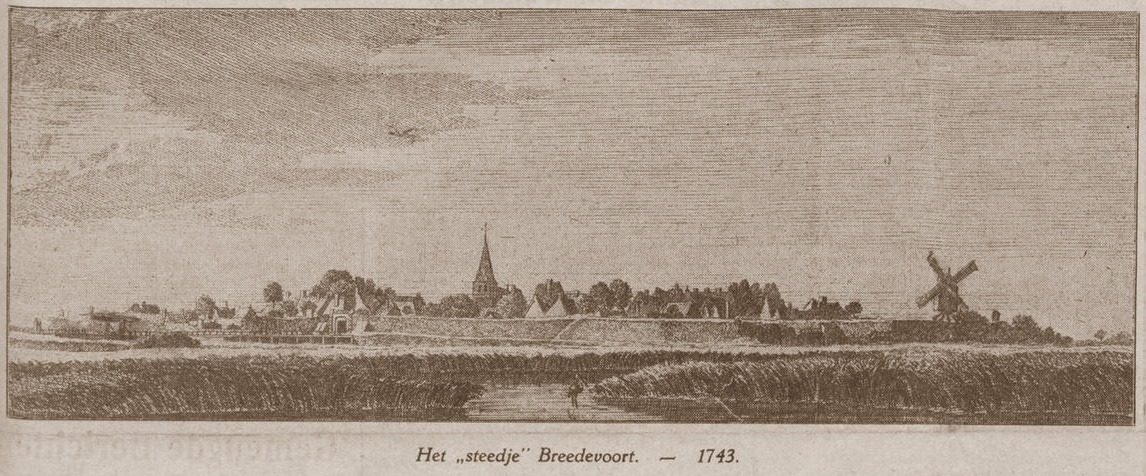
Illustration by Jan de Beijer from 1743, featuring the Ossenkop bastion in the foreground and the Aalterpoort to its left
The noise of war and military activity echoed within the fortress for centuries. Even into the 18th century, three companies of infantry were garrisoned in Bredevoort under the command of a commander, who had a major under him. Especially during the Eighty Years’ War, things were intense in and around Bredevoort. In the late sixteenth century, the Spanish held the fortress. On the first of October 1597, Prince Maurice arrived before Bredevoort with his army. He summoned the garrison, which consisted of only two banners of infantry, to surrender. But they replied that they would keep their weapons for God and the King until their final breath. The Spanish relied on the natural strength of the fortress. Prince Maurice then laid siege to Bredevoort.
As mentioned, there were two access dikes to Bredevoort, but Prince Maurice had a third access road constructed through the Koppele. That road through the marsh was made with sand and brushwood. The sand was brought in bags by the soldiers. In just 8 days, that road, 500 paces in length, was completed. It was then possible to take a height across the moat, suitable for placing 20 pieces of artillery. A murderous fire was then opened upon the fortress. But the besieged defended themselves bravely, and many attackers were killed.
The fortress walls suffered greatly from the cannon fire, and several cracks and breaches had already appeared, yet the garrison still did not surrender. The moat was an obstacle to bringing troops to the front of the ramparts and walls. But Prince Maurice was resourceful, and he had his men build a floating bridge, a kind of cork or rush bridge. This was placed in the moat, providing access to the rampart and creating two points of attack. Count Solms led that attack on the eastern side, from the direction of the Broek. But the resistance was not yet broken. The besieged returned the enemy fire with cannon and muskets. The besiegers were also pelted with stones, and many stormers bit the dust. But it could not last much longer; the attacks became increasingly fierce until finally, a drummer from the city appeared on the wall and gave a signal that they wished to negotiate. But an enemy bullet struck him, and the drummer, who came with peaceful intentions, was killed by a bullet.
The inhabitants of the fortress renewed the attempt to negotiate. They held up sticks with hats, but the besiegers paid no attention to this. Then the women went onto the ramparts to testify to the will to surrender. It is incomprehensible that the besiegers still paid no heed to this. Did they fear a trap, or was it the cruelty of that era that demanded blood? In any case, Maurice’s sailors stormed the stone bastion, entered the fortress, and immediately killed 70 people. The survivors fled to the castle, which was immediately surrendered unconditionally by treaty on October 9th. Prince Maurice spared the lives of all, but stipulated a sum of money for his troops, which was later waived.
Except for the castle and 20 houses, all buildings, including the church, had burned down. The Spanish commander Domiaan Gardot was granted mercy, although he was initially to be executed. During the Spanish occupation, this Gardot had made himself hated by the citizenry.
Prince Maurice, who had entered the gates of Bredevoort victoriously, stayed in Bredevoort for only a few days. He moved further north. A few months earlier, he had taken Groenlo, and now he went via Groenlo to the Overijssel region to make conquests there. Bredevoort kept a small garrison, and the population worked with all their might to rebuild the burned houses. But hardly had the building begun when fire broke out again, and of the approximately 20 houses that had been spared during the siege, 14 burned down, leaving only 6 houses.
There was bitter suffering then. The church had to be rebuilt, but the means were lacking, and letters of appeal were sent to sister congregations for support. However, they did not lose heart. They began rebuilding the church and the burned houses, and gradually the town had habitable houses again. But it was and remained wartime, and dangers threatened from all sides.
In 1606, the Spanish appeared before the city again. It was Shrove Tuesday, and people wanted to celebrate in the city. The soldiers, in particular, were out on the town. There was celebration and merriment, and the soldiers drank heavily. And while they were having fun, the enemy crept up. The Spanish commander Du Terrail arrived quietly from Oldenzaal with 1,200 men and appeared before the city gates in the evening. The guard was on duty, and they were told that the newcomers were soldiers of Prince Maurice being pursued by the Spanish. They lied to the guard and even claimed they had captured a Spanish lieutenant. They requested permission to stay under the protection of the fortress. The guard sent a message to headquarters, and while deliberations were taking place there, it was realized they had been deceived. The population was already fleeing to the castle, and the Spanish were already storming the gates, blowing them up, and before anyone fully realized what was happening, the enemy army was already entering the town.
The Shrove Tuesday joy was cruelly disrupted. The Spanish soldiers killed everyone they encountered, including many women. The minister’s wife also fell victim to the killers. The castle, however, offered a safe refuge for the citizens and soldiers who had fled there. The bridge over the moat surrounding the castle was destroyed, making it temporarily safe within the thick walls. The Spanish were fired upon from the castle, and help also arrived from outside. Count Henry of Nassau appeared with an army from Zutphen and other fortresses, and on March 22nd, the Spanish were forced to surrender. The Spanish commander Du Terrail negotiated a free retreat, which was granted to him provided he returned the booty and prisoners that had already been transported to Oldenzaal. The Spanish did not show themselves again, and the worst suffering was over.
The year 1646 was another year of disaster for Bredevoort. It was July 12th, and an oppressive heat hung over the city. Dark clouds gathered, and everything indicated that a heavy thunderstorm was imminent. And indeed, lightning soon cleaved the sky, followed by heavy claps of thunder. And suddenly, a tremendous blast, followed by a terrible sound. Lightning had struck the gunpowder tower, causing the stored gunpowder (320 tons) to explode. The entire tower was blown apart, as was the nearby Administrative House (Ambthuis); tiles were ripped off almost all houses, and windows were blown in by the air pressure. The number of deaths in that disaster was 19 at the castle and the Administrative House alone. There were also numerous deaths in other houses in the city.
The year was 1672. War had broken out with the Bishop of Münster and Cologne, England, and France. The general-watchmaster of the Bishop of Münster crossed the borders with 2,000 men and laid siege to Bredevoort. The garrison consisted of 500 men, and 20 pieces of artillery stood on the ramparts. In the warehouse was a stock of 20 lasts of rye and 1,800 barrels of gunpowder. The commander of the garrison, Adriaan van Keppel, had repeatedly asked the Deputies of the County of Zutphen for reinforcements of supplies, but in vain. From June 13th to 18th, the fortress was bombarded. The garrison began to mutiny. The women in the city also began to grumble. Rumors spread that the Prince of Orange had been defeated with his army. Fear took hold of the garrison, and on June 18th, the city surrendered, although according to experts, this had not been necessary. The garrison marched away, and fortunately, no looting occurred.”
The year 2026 marks exactly seven centuries since the political map of the eastern Achterhoek was drawn. On 28 June 1326, the Treaty of Wesel and an astronomical mortgage sum put an end to the ‘Bredevoorter Fehde’ (the Feud of Bredevoort). Consequently, the Lordship of Bredevoort – including the jurisdictions of Aalten, Winterswijk, and Dinxperlo – came under Guelders control. This is a reconstruction of a bitter, four-year war of attrition that would change the region forever.
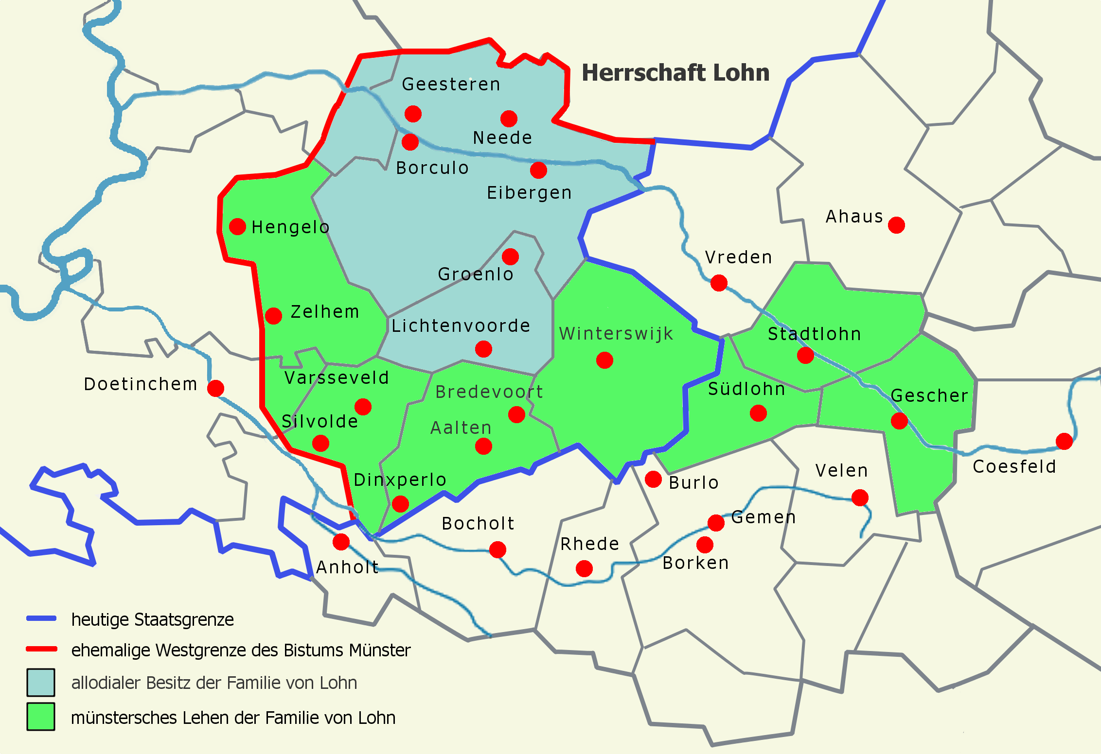
Anyone looking at the national borders around Aalten today will see a historical relic that leads straight back to the Middle Ages. The fact that this region belongs to Gelderland, rather than Germany, is due to geopolitical entanglements in the early fourteenth century. Until 1316, the border area was ruled by the Counts of Lohn. When Count Herman II of Lohn died childless that year, the county vanished, creating a power vacuum around the strategic castle of Bredevoort.
Even then, Bredevoort Castle was a flashpoint. Half of it had been held by the Bishopric of Münster since 1284; the other half was inherited by Otto of Ahaus in 1316. Troops belonging to Ludwig II, the Prince-Bishop of Münster, immediately occupied the entire castle. Although the Count of Guelders, Reinald I, also laid claim to the territory, he did not intervene militarily straight away. Instead, he concluded a three-year truce. It was only under his successor, Reinald II, that the conflict escalated into a true status war, with Guelders receiving active support from Count William III of Holland.
In the summer of 1322, Reinald II managed to capture Bredevoort Castle in a surprise attack. To offset the expenses incurred, he marched through the Münster lands with 700 knights and infantry, plundering as they went. This heralded a ruthless four-year guerrilla war.
Sleeping knights and a captured bishop
The conflict was characterised by lightning raids and heavy casualties. One of the most remarkable confrontations took place in March 1323 near the town of Dülmen. A military unit from Borken, supporting the Bishop of Münster, surprised the Guelders army while the knights were asleep. The Borken forces deliberately killed the knights’ horses. Encased in their heavy armour, the Guelders warriors were virtually defenceless without their mounts; 86 knights and squires were killed, and a hundred knights were captured for ransom.
However, the tables turned quickly. In May 1323, Prince-Bishop Ludwig II of Münster himself was captured by Engelbert II van der Mark, an ally of Guelders. The bishop was only released in November of that year, following the payment of an astronomical ransom of 5,000 silver marks.
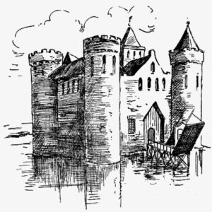
Bredevoort Castle in 1597
The peace that followed was short-lived. As soon as the bishop was free, he recaptured Bredevoort. By 1324, the armies faced each other once more near Coesfeld. It had become a full-blown European conflict: Reinald II had assembled an army of 7,000 cavalry, backed by the King of Bohemia, the Counts of Flanders, Holland, Artois, Van der Mark, Jülich, and Van den Bergh, as well as the Bishops of Liège and Utrecht. Münster was supported by troops from Osnabrück, the Lords of Lippe, the Counts of Waldeck and Sayn, and a host of Frisians, Hessians, Thuringians, and Franks.
As the armies stood face-to-face near Coesfeld, a massive pitched battle loomed. However, King John of Bohemia and Count William III of Holland managed to persuade the sparring factions to reach a compromise, leading to the signing of a treaty on 1 September 1324. The Bishop of Utrecht subsequently delivered a binding, yet nuanced, arbitration on the claims in Deventer. Münster demanded that Guelders renounce its rights to Bredevoort, the Honborn jurisdiction, and the Reken estate. The Bishop of Utrecht ruled that both parties had to defer to the feudal overlord regarding Bredevoort. He was unable to rule on the remaining territories due to ancient feuds, though Münster was awarded 500 marks in damages.
Since this ruling did not resolve the underlying tensions, the war flared up again unabated in early 1325. This led to the brutal destruction of the Münster-held part of the town of Vreden by Guelders troops on 3 January 1325.
The Treaty of Wesel (1326)
By 1326, both sides were financially and militarily exhausted. Mediated by Count Dietrich of Cleves and his brother John, the parties reached a definitive agreement in the Hanseatic city of Wesel.
The peace terms dictated that Bredevoort Castle was permanently awarded to Reinald II of Guelders. In return, the Count of Guelders had to return the occupied Lordship of Bermentfelde (present-day Barnsfeld near Südlohn) to Münster, in exchange for 3,500 marks in compensation.
It was here that the decisive financial mechanism came into play: bankrupt from the earlier ransoms and years of warfare, the Bishopric of Münster could not afford to pay these 3,500 marks. As security (a pledge) for this sum, the bishop mortgaged the jurisdictions of Winterswijk, Aalten, and Dinxperlo, along with the corresponding county court (vrijgraafschap), to Guelders. On 28 June 1326, this official peace treaty was signed, co-sealed by the Guelders towns of Zutphen, Groenlo, Arnhem, and Emmerich.
The legacy of an outstanding debt
The treaty stipulated that Münster could redeem the pledge — and thus regain governance over the three parishes — at any time by repaying the mortgage sum to the magistrates (schepenen) of Wesel. However, over the following centuries, Münster never managed to raise the funds.
What began as a temporary mortgage thus became a permanent arrangement. The Lordship of Bredevoort remained permanently part of Guelders territory and later formed the Bailiwick (Ambt) of Bredevoort. The borders of these medieval jurisdictions are still visible today in the municipal boundaries of the eastern Achterhoek. An unredeemed debt from 1326 thus determined that the residents of Aalten, Winterswijk, and Dinxperlo are Gelderlanders today, and not Westphalians.
Bredevoort Castle, 3D impression by Paul van Druten
Bredevoort Castle was a fortress in the heart of the eponymous town and former Lordship of Bredevoort in the County of Zutphen within the Duchy of Guelders. It was one of the most significant castles in Gelderland. During the 13th and 14th centuries, Bredevoort Castle played a major role in the struggle between Guelders and Münsterland.
The castle was first mentioned in 1188 on a list of properties belonging to the Diocese of Cologne as “Castrum Breidervort“. At that time, the castle was a site of contention. Consequently, it had multiple owners, leading to a centuries-long struggle for control. In 1238, the castle came into the hands of Ludolf van Steinfurt and Herman van Lohn as a shared inheritance. The castle was to be fortified, with both parties sharing the costs. In 1278, the fortress was destroyed by Count Everhard I von der Mark during an act of revenge. Following this, the castle remained a ruin for 23 years. A deed of sale from 1284 refers to the “area castri Bredevort”.
After years of conflict over Bredevoort between Münster and Guelders, the castle eventually returned to the hands of Count Herman van Lohn II in 1301. In that year, the bishops of Münster and Cologne pledged to assist Herman van Lohn with the restoration of the fortress. In the turbulent times that followed, the fortress frequently changed hands between Münster and Guelders through combat or sale. The bishops of Münster and Cologne were required to jointly fund the reconstruction of Bredevoort Castle.
After centuries of fighting over the castle, the Bishop of Münster abandoned the struggle and sought peace negotiations. Following years of negotiation, peace was finally signed on June 28, 1326, with the Treaty of Wesel. This significant treaty was also signed by the cities of Zutphen, Groenlo, Emmerich, and Arnhem. As a result, Reinoud II of Guelders acquired the pledge of the jurisdictions in Winterswijk, Aalten, and Dinxperlo, as well as the County of Bredevoort. This move definitively incorporated the area into Gelderland.
In 1882, J. Craandijk produced two drawings intended to represent Bredevoort Castle. Whether these are accurate, however, remains a matter of debate. Bredevoort Castle, ‘the Hall’
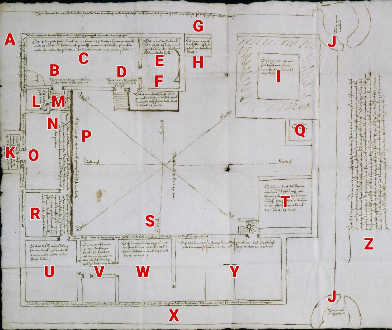
Floor plan
In 1562, the lord of the manor of Bredevoort, Diederik van Bronckhorst-Batenburg, Lord of Anholt, commissioned a floor plan of the castle at Bredevoort. This plan also described the functions and structural condition of the various components. Measurements were recorded in Rhineland feet. A Rhineland foot is over 31 cm long. The castle was a rectangle measuring 42 m long and 36 m wide. The walls were approximately 65 cm thick. An earthen rampart surrounded the castle, with roundels at the corners. The rampart was approximately 2 m wide.
Floor plan of Bredevoort Castle, 1562
Explanations of the descriptions on the floor plan (translated from old script):
This vault will collapse if it is not repaired soon.
Here is the staircase leading to the knights’ hall.
This wall is dilapidated. The vertical beams are rotted at the bottom. This is a large hall: 47 feet long and 23 feet wide, measured from the inside. Beneath it is a cellar. The floor consists of beams and planks and is finished with floor tiles. There is only one attic above the hall.
This is a staircase to enter the large hall.
This is the kitchen, 21 feet long and 23 feet wide. Beneath it is a cellar of the same size as the cellar under the large hall.
This shed was built by Drost Isendoorn. The walls are masonry set between beams.
This is the rampart that runs around the castle.
This is a very dilapidated shed, much like a pigsty.
The prison tower. It is 38 feet square (measured from the outside). The walls are 8½ feet thick. [This tower was likely used later as a powder tower, Ed.]
Here are two roundels.
The Drost’s chamber (Maarschalcksekamer) above the gate. [The name ‘Maarschalckse kamer’ dates from the period 1534-1555 when Marshal Maarten van Rossum was Drost of Bredevoort, Ed.]
This is the chapel.
From here, the hearth of the knights’ hall is stoked.
This is the knights’ hall. The room is 36 feet long and 19 feet wide. Below this are the rooms of the burgrave (castle warden) and the steward. The gate entrance is also located below here.
This wall is in good condition, as far as it can be seen above the rampart.
This wall is built between wooden beams and has a thickness of half a brick. [The bricks used were ‘kloostermoppen’ of approximately 14 cm in width, Ed.]
A dilapidated spiral staircase.
Another room. Below this is a laundry room. Because the rampart rests against the laundry room, the wall is rotted. The stones are loose.
This wall is largely built between wooden beams and is very dilapidated.
This contains the grain mill and the baking ovens. Above is the servant’s room, with two attics and a chimney.
This is where the Drost sleeps. The room is 28 feet long and 23 feet wide. Beneath it is a meat cellar.
This room is divided in two. The floor is made of wood. The meat cellar also lies beneath this area.
This upper room is called the salon (state room, armory). Below it is the armor room.
Here the rampart touches the wall, causing the wall to let in moisture and show defects. The wall is very thick, and if the water could be kept out, it would likely provide some improvement.
These two rooms, as well as the granary, are located above the bakehouse and brewhouse.
This drawing was made in Arnhem after everything was measured as accurately as possible. The drawing is fairly accurate. However, in reality, some parts are slightly larger than depicted here, such as the chapel, the spiral staircase in the courtyard, and the prison tower.
Not much is known about exactly how Bredevoort Castle looked. While drawings of the castle exist, they are partly based on assumptions and imagination.
The castle was built on a sandy ridge of approximately 42 x 26 meters, making it one of the larger castles in the Netherlands. Old maps show the main fortress to be a typical concentric castle, featuring double moats and a thick curtain wall. It included an outer bailey with heavy corner towers and a rectangular castle wall equipped with four corner towers, three of which were later lowered to become roundels.
The castle and the town were separated by a double moat. Access to the castle from the town was via a bridge. One had to pass through two gates, the second of which was equipped with a barbican, and finally a gatehouse in the curtain wall before reaching the inner courtyard. Within the fortress, various buildings stood around a spacious inner court. These depictions changed over time, and the appearance and stature of the castle would have been altered frequently throughout the centuries due to conflict, war, city fires, and other causes.
Destroyed
The castle was heavily damaged by the Gunpowder Tower Disaster in 1646. Following this, the castle dominated the cityscape as a ruin for over 150 years until around the end of the 18th century. The last known mention of a visible ruin dates to 1791, recorded in the Bredevoort church council minutes when William V viewed the remains during his visit to Bredevoort. The main building (excluding the outer bailey, roundels, and curtain wall) had dimensions of approximately 42 x 36 meters. This made it one of the larger castles in the Netherlands.
Bredevoort Castle in 1597
Remains
Today, the remains of the castle—in the form of foundations, vaults, tunnels, and rubble—lie beneath and around the ‘t Zand square and the Hozenstraat in the heart of the town. In the spring of 2009, during archaeological research around the former school on ‘t Zand, part of the foundations was uncovered. Wall remains between 2.5 and 4 meters thick were found. On ‘t Zand square, foundations of the barbican were discovered. The contours of this gatehouse have been made visible in the paving with brass-colored bands.
Historical sources reveal that Aalten was mentioned in 1152 as the parish of Aladon1. This indicates that a church existed at that time, which was presumably located on the same site as the current Old Helenakerk. A mention from 828 (Aladna)2 is not undisputed, although such an early dating for Aalten is certainly possible from an archaeological perspective. Indeed, traces of human habitation from that period have been found both at De Hoven and on the Damstraat.
Burial Ground
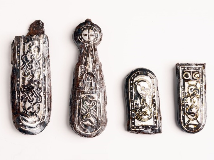
In the late 19th and early 20th centuries, a large number of objects were collected during excavation work on Damstraat. Among the finds are 15 pots of widely varying shapes, some of which are beautifully decorated.
In 1932, under the direction of Professor A.E. van Giffen, a burial ground was uncovered in Aalten behind the Manschot factory, now Manschotplein. Spearheads, stirrups, a shield boss, several small pots, and ten silver links from a belt were found.3 It is not unlikely that these finds originate from the grave of a single warrior.
Part of the Damstraat was likely a Merovingian-Frankish burial ground around the year 800. The Merovingians were a dynasty of Frankish kings. The site has been heavily disturbed by house construction.
Belt fitting, found at Damstraat in Aalten
Medieval Cellar
Naturally, a burial ground is associated with a settlement. You will understand that we were very curious about where this settlement was located. In recent decades, a working group from the archaeological society A.D.W. has closely monitored excavation and construction activities in and around the current center of Aalten. In 1981, this resulted in the discovery of a cellar from the 12th century. The find was made in the renovated premises of what was then the Welkamp company (Bredevoortsestraatweg 5). No remains were found of the farmhouse of which the cellar was a part. However, the cellar itself yielded a wealth of information.
Because the cellar had been destroyed by fire, all objects present at the time of the fire were recovered within it. A total of six pots were found which, given their size, must have been used as storage jars. Unfortunately, five of the six pots were broken. A handle from a saucepan, in the shape of an animal head, was also found. Iron slag and a piece of lime indicate a smithy in the vicinity. It is possible that two hinges found were manufactured in this smithy.
Bone remains showed that horses, sheep or goats, cattle, and pigs were kept. Charred grain remains of oats, wheat, and rye were found in a soil sample. With this find, the mention from 1152 was archaeologically confirmed. Several imported shards from Germany point to a dating in the second quarter of the 12th century.4
Settlement
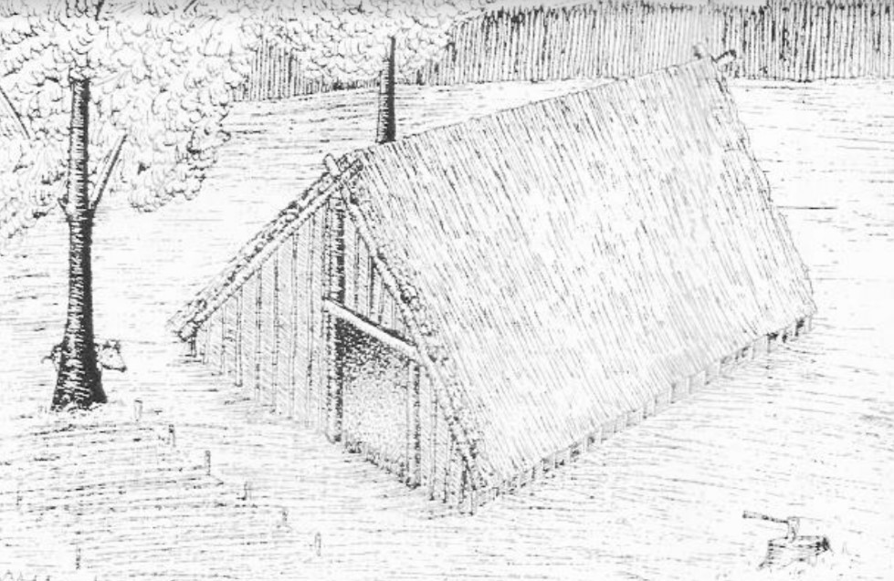
Although this find was important in itself, no traces had yet been found of the older settlement associated with the burial ground. However, during the redevelopment of De Hoven in December 1982, traces of a Frankish-Merovingian settlement were discovered. The remains of a sunken hut from the 9th century5 are an indication that Aalten already existed at that time, albeit under a different name.
A sunken hut should be imagined as a rectangular pit topped by a gable roof. Usually, these sunken huts had a craft function (e.g., a weaving hut) or a storage function. Only the larger ones were possibly also used as dwellings.
This is what the Aalten hut bowl could have looked like (sketch made by Willem Doodeheefver)
After the sunken hut was abandoned, the pit was used as a refuse pit. A large number of bones from the same livestock as in the cellar find were discovered here. The discovery of bone remains from a deer indicates a minor role for hunting. Furthermore, charred grains and seeds such as barley, rye, emmer wheat (a prehistoric grain type), oats, lentils (possibly peas or vetch), pale-yellow hemp-nettle, goosefoot, and sheep’s sorrel were found.
From the fact that pottery types found in the sunken hut also occur in the burial ground, we may conclude that both are contemporaneous. It is therefore not far-fetched to assume that the people who lived at De Hoven buried their dead at the current Damstraat.
Second Find
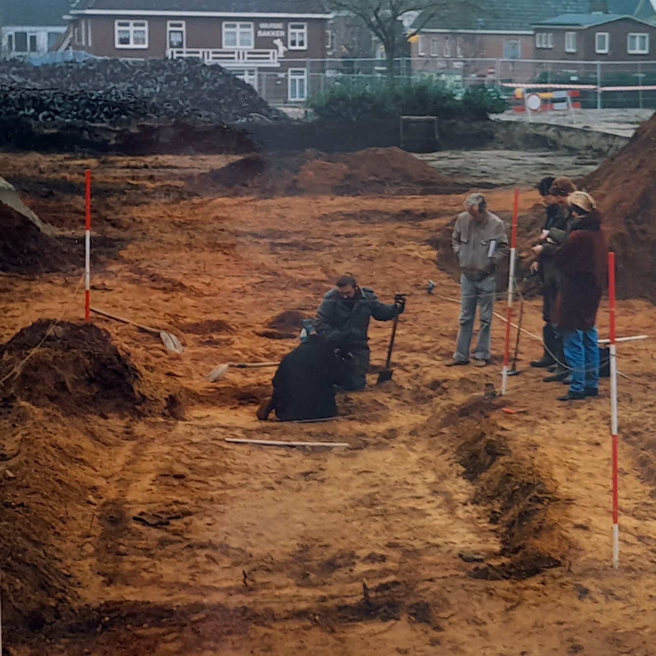
In December 1992, during work at De Hoven, not far from the previous site, remains of a sunken hut were found again, this time probably dating from the 8th century. This sunken hut was found on the grounds of De Hoven where road builder Jaartsveld was carrying out excavation work for the construction of a new parking lot.6
This sunken hut was quite small and had almost certainly been the workshop of a weaver. A groove on the side of the pattern found indicated where the loom had stood. Spindle whorls and clay balls that served as weights for the loom were also found. The sunken hut was smaller than the one discovered in 1982. That one may have been a hut where a family lived.
Archaeological research at De Hoven, 1992. Photo: Peter Rhebergen
Willem Doodeheefver, one of the amateur archaeologists involved in the research, told a reporter:
“You know it is an area in the vicinity of which something has been found before. You could see it very clearly during the excavation. Suddenly, in the red sand, the black imprints became visible where posts used to stand. That is always a huge surprise.”
The National Service for Archaeological Heritage (ROB) recognized the importance of the finds and asked the Soil Research Working Group of the Archaeological Society A.D.W. to continue the investigation. An employee of Jaartsveld specifically returned from vacation to further excavate the site using a loader. Several new finds were made during this process. Many of the aforementioned finds can be viewed in the museum on the Markt.
Origin of the place name
Several theories circulate regarding the origin of the name Aalten. But what are they based on and how credible are they? Old Aalten delved into history to discover more about this.
From historical sources, we know that Aalten was mentioned in 1152 as the parish of Aladon.1 However, there are indications that the village may have been mentioned much earlier, namely as Aladna in a charter from 828.2 Whether this mention actually refers to the current Aalten is still a subject of discussion. Nevertheless, archaeologists consider such an early dating certainly possible. Indeed, traces of human habitation from that time have been found both at De Hoven and on Damstraat.3 In this article, we delve into this ancient mention and examine two different theories.
The deed of gift of Geroward
The charter from 828 describes how, on February 7 of that year, a certain Geroward donated all his possessions, including those in Aladna, to the St. Martin’s Church in ‘Traiectum Veteri’ (Utrecht). Little is known about Geroward’s identity, but he must have been a man of standing. He was presumably a Frankish nobleman in the service of the Carolingian Emperor Louis the Pious, son of Charlemagne.
The original charter has not been preserved. What we know about it comes from later copies and transcriptions. The most important source is the ‘Cartulary of Radboud’, compiled in the Abbey of Egmond in the 12th or 13th century. This register contains copies of charters related to the Diocese of Utrecht. Later, this collection was included in the ‘Oorkondenboek van het Sticht Utrecht tot 1301’, compiled by S. Muller Fz. and H.T. Obreen.
Below are the Latin text and the English translation of the charter in question.
Source text
Dum unusquisque presens seculum inhabitat, necessitate nimia cogitur, ut finem suum Dei solo judicio previdere et preoccupare bonis operibus studeat, ne eum inopinata et improvisa mors inveniat.
Idcirco ego Gerouuardus, filius Landuuardi, trado ad ecclesiam sancti Martini, in Traiecto Veteri constituta[m], quicquid mihi hereditatis jure accessit in villa Langhara et in Ellenuuih et in Aladna et in Uuazefelde et in Humelle et in Theodon et in Hesim et in Asnon, cum omnibus adjacentiis, pratis, pascuis, silvis, aquis aquarumve decursibus, necnon et mancipia, quorum hec existunt vocabula: Feginuuard et uxor ejus Liutburn, Meginrauan et uxor ejus Vuerinhild, Albuuard et mater ejus Sigiuuih, Uulfbald et Hadagrim, Grimbald et uxor ejus Adaluuih, Garoberd et uxor ejus Folcuuihc, Arnolf et uxor ejus Adalgard, Saxani et uxor ejus Harduuih Vuerinbald et mater ejus Gerild, Heiegbrath et uxor ejus Meginfrid, Vuarbald et uxor ejus Geruuih, Adalgod et Marcuui, Saxini et Radini, Vulfini et uxor ejus Liuduuar, Odilgard et filius ejus Heriman, Aldric et filius ejus Landric, Gelo et Marcrad, Hungrim et uxor ejus Liuduuih, Aluuih et Seolo, Egbald et Tadhild.
Acta est autem publice in villa Embrici, anno XV imperii domni Hludouuici imperatoris, incarnationis vero Dominice anno DCCCXXVIII, die VII Idus Februarii, coram testibus, qui hanc traditionem presentialiter confirmatam viderunt similiter et vestituram, quorum nomina subter notantur.
Ego Geraccarus jubente domno meo Friderico episcopo scripsi et subscripsi.
Translation
While every man dwells in this earthly life, he is driven by a great necessity to foresee his end only through God’s judgment and to prepare for it through good works, lest death overtake him unexpectedly and unprepared.
Therefore, I, Geroward, son of Landward, transfer to the church of Saint Martin, located in Old Traiectum, everything that has come to me by hereditary right in the villages of Langhara, Ellenwih, Aladna, Wazefelde, Humelle, Theodon, Hesim, and Asnon, with all associated lands, meadows, pastures, forests, waters, and watercourses.
Likewise, I transfer the serfs, whose names are as follows: Feginward and his wife Liutburn, Meginravan and his wife Werinhild, Albward and his mother Sigiwih, Wulfbald and Hadagrim, Grimbald and his wife Adalwih, Garoberd and his wife Folcwih, Arnolf and his wife Adalgard, Saxani and his wife Hardwih, Werinbald and his mother Gerild, Heiegbrath and his wife Meginfrid, Warbald and his wife Gerwih, Adalgod and Marcwi, Saxini and Radini, Wulfini and his wife Liudwar, Odilgard and her daughter Heriman, Aldric and his son Landric, Gelo and Marcrad, Hungrim and his wife Liudwih, Alwih and Seolo, Egbald and Tadhild.
This transfer took place publicly in the settlement of Embrici, in the fifteenth year of the reign of Emperor Louis(Hludowicus), and in the year 828 after the incarnation of our Lord, on February 7, in the presence of witnesses who confirmed this transfer and the associated settlement. Their names are listed below.
I, Geraccarus, have written and signed this by order of my lord, Bishop Frederick.
Where was ‘Aladna’ located?
There are two theories regarding the exact location of the places mentioned in the charter:
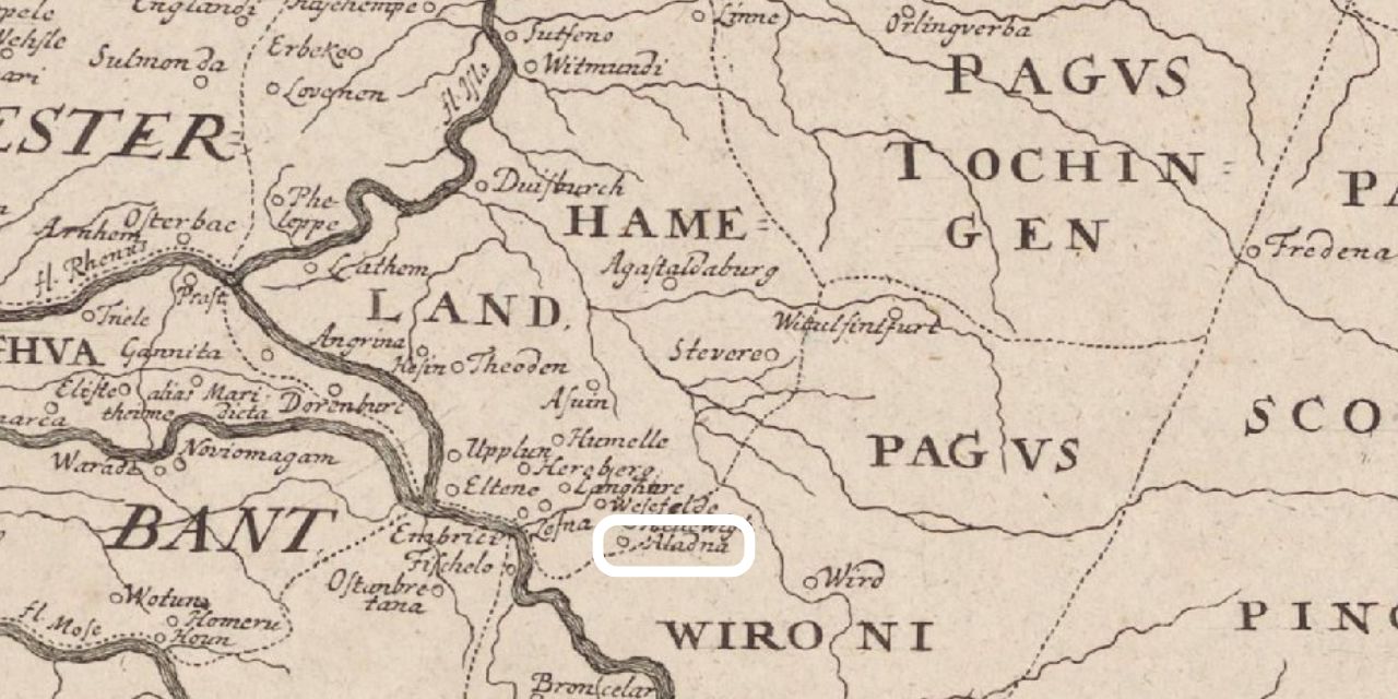
The Hamaland theory: According to this view, Geroward’s possessions were located in the area that would later become known as the Carolingian county of Hamaland. The place names mentioned in the deed are linked by historians to contemporary locations in the Liemers and the Achterhoek. Within this theory, ‘Aladna’ is identified as the current Aalten.
The North French theory: Another interpretation suggests that the mentioned places were not in the Netherlands, but in Northern France. In this scenario, Aladna would refer to the current Alette, a place in the Pas-de-Calais department. The other place names from the charter would also be located in this area.4
Interpretations of the place names in both theories:
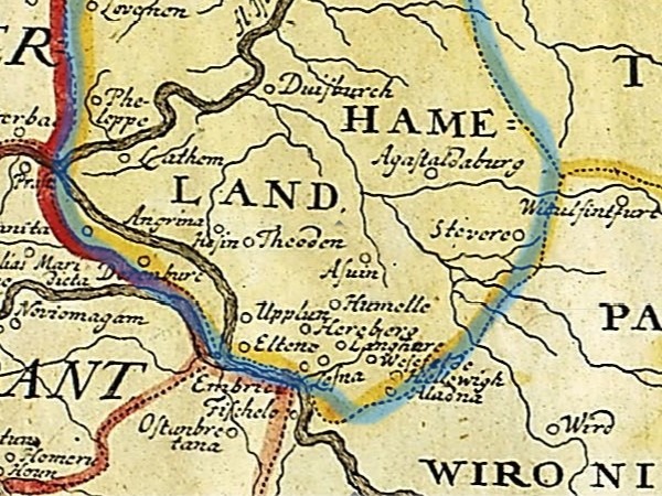
In the eastern regions of the Netherlands, however, it is assumed that the Hamaland theory is the most likely. It is not without reason that the municipality of Aalten named a road after this mention: the Aladnaweg. And in the municipality of Montferland, a street is named after Geroward: the Gerwardstraat in Klein-Azewijn. The theory is centuries old: around 1730, Johann Friedrich Falken created a historical map of ‘the Netherlands in late Roman times’, on which he drew the county of Hamaland, including Aladna.
Map of the former county of Hamaland in late Roman times, created by Johann Friedrich Falken, ca. 1730 5
Conclusion
The mention of Aladna in 828 remains an interesting subject of discussion. Many people consider the Hamaland theory to be the most likely explanation (or is that perhaps mainly wishful thinking?), but the North French interpretation cannot be entirely ruled out. Hopefully, future archaeological and historical research can provide more clarity regarding this early mention.
Origin of the place name
Several theories circulate regarding the origin of the name Aalten. But what are they based on and how credible are they? Old Aalten delved into history to discover more about this.
Deze website gebruikt cookies voor een optimale ervaring en analyse van bezoekgegevens. Ga je hiermee akkoord? Zonder toestemming werken sommige onderdelen van de site mogelijk minder goed.
Functioneel
Always active
De technische opslag of toegang is strikt noodzakelijk voor het legitieme doel het gebruik mogelijk te maken van een specifieke dienst waarom de abonnee of gebruiker uitdrukkelijk heeft gevraagd, of met als enig doel de uitvoering van de transmissie van een communicatie over een elektronisch communicatienetwerk.
Voorkeuren
De technische opslag of toegang is noodzakelijk voor het legitieme doel voorkeuren op te slaan die niet door de abonnee of gebruiker zijn aangevraagd.
Statistieken
De technische opslag of toegang die uitsluitend voor statistische doeleinden wordt gebruikt.De technische opslag of toegang die uitsluitend wordt gebruikt voor anonieme statistische doeleinden. Zonder dagvaarding, vrijwillige naleving door je Internet Service Provider, of aanvullende gegevens van een derde partij, kan informatie die alleen voor dit doel wordt opgeslagen of opgehaald gewoonlijk niet worden gebruikt om je te identificeren.
Marketing
De technische opslag of toegang is nodig om gebruikersprofielen op te stellen voor het verzenden van reclame, of om de gebruiker op een site of over verschillende sites te volgen voor soortgelijke marketingdoeleinden.